After cool and mixed weekend, the weather is set to turn hot across parts of England this coming week, 31C is possible on Wednesday, but signs of a thundery breakdown of the heat on Friday.
The blustery and mixed weekend continues, with many areas seeing a soaking overnight from a band of rain now clearing the east coast, sunshine and showers following for Sunday, which will be heavy with a risk of thunder across the north and west. However, temperatures are on the rise this coming week, as high pressure builds on the near continent and we draw in a very warm southeasterly flow, with potential for temperatures in the sunshine to reach 31C across parts of England on Wednesday. However, not all areas will enjoy hot and sunny weather, with a troublesome wriggling weather front bring cloudier skies and rain at times across Scotland, far north of England and Northern Ireland, the rain heavy at times across the far northwest.
For now, band of rain crossing the UK from west to east overnight will clear the far east by mid-morning, though lingering longer across the far north of Scotland and the Northern Isles. Brighter skies with sunny spells following from the west, but showers already across Wales, Cumbria and Ireland will spread further east through the day.
So, a blustery day with sunny spells and scattered showers blowing through on a brisk southwesterly wind. Showers becoming heavy and most frequent across Scotland, NW England, Northern Ireland and Wales – where they may be accompanied by hail and thunder. Southern and eastern England seeing fewer and lighter showers, with some places staying dry and sunny.
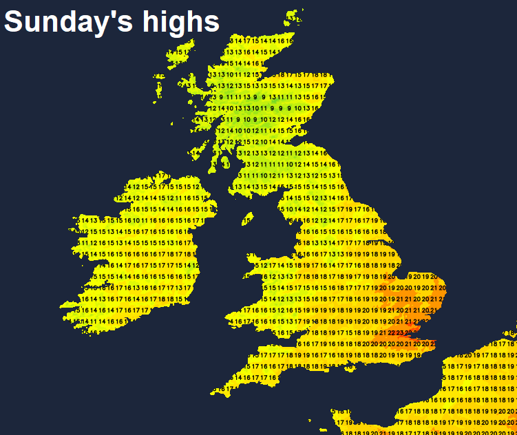
Feeling cooler and fresher than Saturday, especially across the north and west, thanks to the brisk southwesterly wind, which will gust to 30-40mph around coasts. Afternoon highs reaching 16-18C across Scotland and N. Ireland, 18-22C across England and Wales, warmest temperatures across eastern England.
Heavy thundery showers across the north and west and lighter more scattered showers elsewhere initially this evening will tend to die out overnight, with much of the UK becoming dry overnight with clear spells. Thickening cloud and rain perhaps creeping in across the west of Northern Ireland by dawn. A cooler night, temperatures falling into single figures in more rural areas.
A frontal system moving northeast off the Atlantic across the north and far west on Monday will bring windy conditions with cloud and outbreaks of rain northeastward across Scotland, NW England, Northern Ireland, north and west Wales through the day, the rain heaviest across western Scotland and N. Ireland. East Wales, central, southern and eastern England dry and warm with sunny spells – here the highest temperatures reaching 20-23C inland. A cooler 15-18C in the cloudier and wetter north and far west.
Tuesday and Wednesday will see low pressure to the northwest and high pressure close to the east. A wriggling slow-moving cold front lying southwest to northeast across Ireland and Scotland, marking the boundary between cooler and fresher Atlantic air to the west of the front and increasingly warm and humid air to the east across England and Wales, pumping in off a hot near continent. The frontal boundary across the north and far west will bring cloudy skies across Scotland, the far north of England, Ireland and north Wales, with pulses of rain, heavy and perhaps thundery at times, moving northeast – particularly across western Scotland and N. Ireland. But for much of England and Wales it will be fine, sunny and very warm or hot. Highest temperatures on Wednesday, where some inland spots across central and eastern England could reach 30-31C.
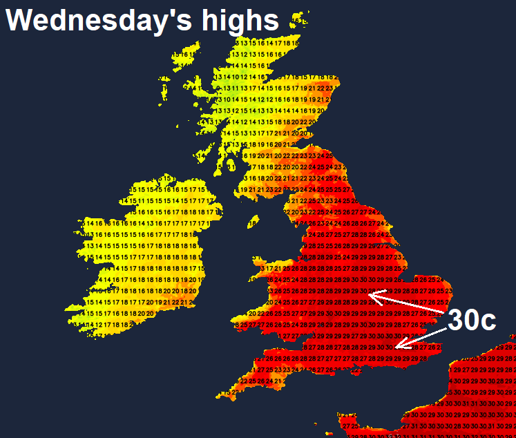
Thursday currently shaping up to be another very warm or hot sunny day for much of England and Wales, temperatures widely in the mid to high twenties Celsius, perhaps 30C again in the east. Scotland and N. Ireland cloudier and cooler with some showers in places.
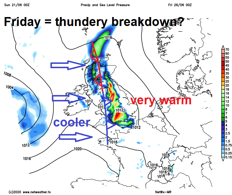
Weather models are currently indicating that hot settled weather will start to break down from the west on Friday. There's some uncertainty over timing, but heavy showers or thunderstorms breaking out across initially across the west either late Thursday before developing further east into Friday. Fresher conditions following across the west, but very warm and humid conditions perhaps hanging on across the east.