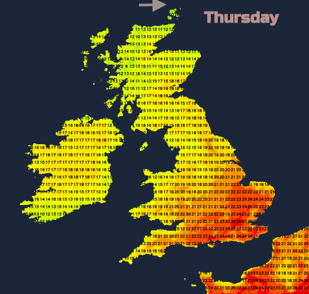
Heat building across the UK in the May sunshine today, with temperatures perhaps reaching 29c, but there is the risk of showers and even thunderstorms on Thursday.
It will be very warm today, tomorrow brings the risk of thunderstorms. Then a deep low with gales and rain on Friday as temperatures return to normal everywhere.
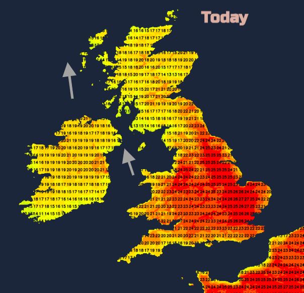
With the forecast showing 28, maybe 29C in England today, we haven’t seen those kinds of temperatures since last August. It will be warm and sunny for much of the UK with temperatures widely into the high teens and 20sC. That heat lasts over SE Britain on Thursday before a patchy band of rain moves in from the west. There is the risk of thunderstorms over SE Britain, from Hampshire across to East Anglia and over the SE of England. As always with showers, it won’t be for everyone, but it will certainly be a change from today’s warmth and sunshine if you do get one.
It already feels warm out there in many parts of the UK, with the promise of a lovely day. Remember your sunscreen. There is some low cloud about. This is bringing patchy rain to the far north of Scotland and will keep some coastal areas cool and grey for a while today around parts of northern Britain and Northern Ireland. However, inland it will thin and break leaving blue skies and sunshine.
Yesterday London saw 26.2C. The highest temperatures today are expected for eastern and SE England, but Manchester could see mid 20sC and Grampian will fair well in the southerly flow. 27 or 28C is forecast today for East Anglia and Cambridge. London might see 29C. There is only a light southerly breeze today for the UK, moderate pollen as we move from the tree pollen to grass pollen season and medium to high UV.
It will be mild overnight, warm in central London and the heat builds again over SE Britain on Thursday, not as warm but still well into the 20sC. The rest of the UK will still be into the high teens, just northern Scotland mid-teens so cooler than today.
There is rain in the forecast, a thin patchy band, a cold front on Thursday from the west which will also help set off a few thunderstorms in the SE. (See below). There is heavier more persistent rain from the deep low on Friday. NW Scotland will be very wet for a time and there will be rain for Northern Ireland, Scotland, NW England and Wales but coming in from the west, eastern areas will be more sheltered.
Heavy showers continue to affect Northern Ireland, western Wales western and northern Scotland and NW England in brisk winds Friday into Saturday but the dry spell continues for many parts of Britain. High pressure then builds again for next week, so little rain is forecast.
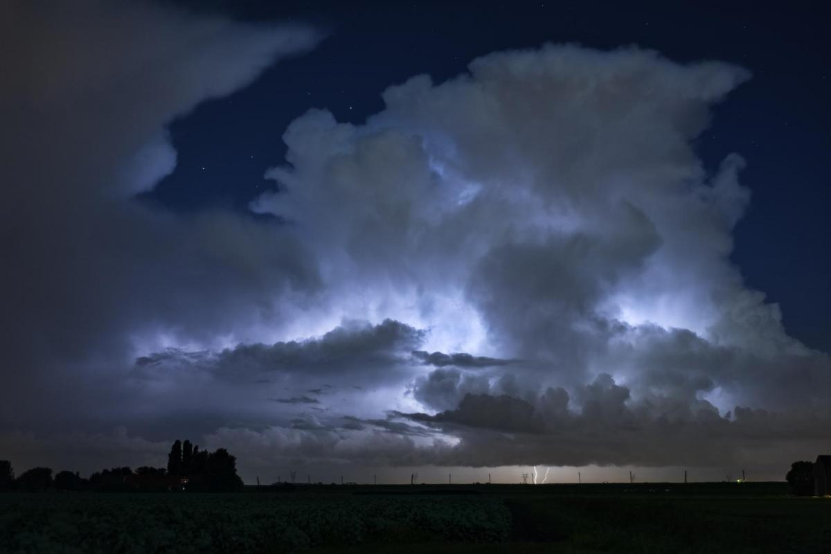
As the cold front moves in from the west it will add to the existing morning elevated instability over SE Britain. As the heat of the day builds surface-based convection will start up leading to further convective activity in the afternoon. The UKV this morning has considerably less action showing than yesterday but the models sometimes can grasp the small scale of thunderstorm development and there is quite a balance of ingredients going on, with the medium level cloud and showers, the incoming trough, the time of day and so surface temps. Have look at Nick Finnis’s guide to thunderstorm forecasting, see what you forecast for tomorrow from the various charts. Southeast England, London and East Anglia look most at risk with SE Britain so from Hampshire across to the Wash and SE wards in with a chance. And the Netweather Radar will show the rain showers and sferics (lightning strikes) as they appear if you just want to track what is going on as it happens.
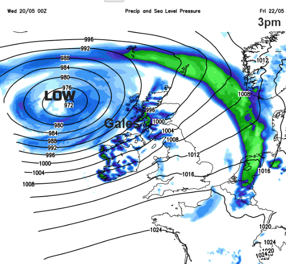
There is still some uncertainty about the position of this deep low but there will be a spell of very windy weather with gales for NW UK. Frontal rain as well with some hefty showers and quite a wild end to the week for Northern Ireland, northern Britain and through the Irish Sea and continuing for the start of the weekend over Scotland.
In Asia, forecasters have been watching Super cyclonic storm Amphan as it heads north in the Bay of Bengal. Millions have been evacuated in West Bengal and Bangladesh with the threat of a devastating storm surge as the Cyclone arrives today, still as an extremely cyclonic storm.