There's plenty happening with the UK's weather this week - heat, thunderstorms and a deep low bringing very strong winds. But, if you're hoping for some persistent rain, there's not going to be much about.
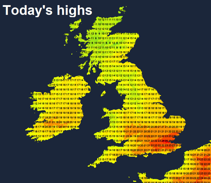
Farmers and gardeners alike will be hoping for some rain, as many places have seen just a small fraction of the average rainfall for May so far. Many places have seen just a few percent of the rolling average, this coming after an exceptionally warm and dry April. There will be some rain in the north today, but for most, the sunny and dry Spring continues over the next few days, temperatures will be on the rise, with the warmest day of the year so far possible tomorrow – reaching 28C in SE England.
The warmth will hang on across eastern England on Thursday, where will see a risk of thunderstorms breaking out locally too. But the general trend is for cooler and increasingly windier conditions to spread east across all parts into Friday, along with some rain or showers, as an unseasonably deep low swings northeast to the west of Scotland. Still little in the rain on the horizon for many away from the far northwest.
For now, it’s been a cloudy and damp start across the north, the heavier and more persistent rain moving across N. Ireland, Scotland and northern England overnight has mostly cleared out into the North Sea, but has left a legacy of grey skies and patchy light rain or drizzle for these areas. It will stay generally cloudy across these areas, the rain mostly fizzling out though further drizzle possible over hills. Some bright or even sunny spells may develop though to the east of high ground. Warm though, especially where the sun comes out, temperatures reaching 18-21C, cooler near western coasts.
To the south of northern England, it’s a drier and sunnier story today, sunshine for some already but there are some extensive areas of low cloud this morning in places, with a little drizzle over western hills, but this cloud should break up and disperse through the morning, with much of England and Wales south of northern England ending up with decent spells of sunshine and warm too. Temperatures widely reaching 20-23C inland, perhaps up to 25C in the London area, but cooler around coasts.
Many places staying dry and fine this evening and overnight, cloudier across the far north and northwest, though any light rain or drizzle tending to fade away from the Northern Isles – where further rain will be possible. A mild night with temperatures generally falling no lower than the low teens.
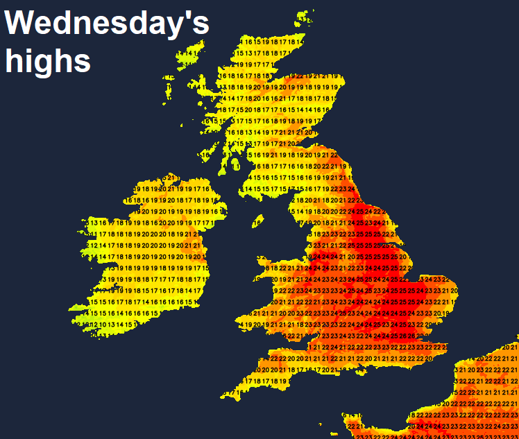
A very warm day in store on Wednesday as southerly winds bring warm air all the way up from Spain and France and, with high pressure building further north, it will be drier and sunnier across northern areas too. Some early cloud in the north and northwest, but this should clear north to leave most areas dry with a lot of sunshine. Temperatures reaching 20-22C across central and eastern Scotland, 17-19C across western Scotland and Northern Ireland. England and Wales seeing highs of 22-25C widely inland away from coasts, 26-28C across central and eastern England.
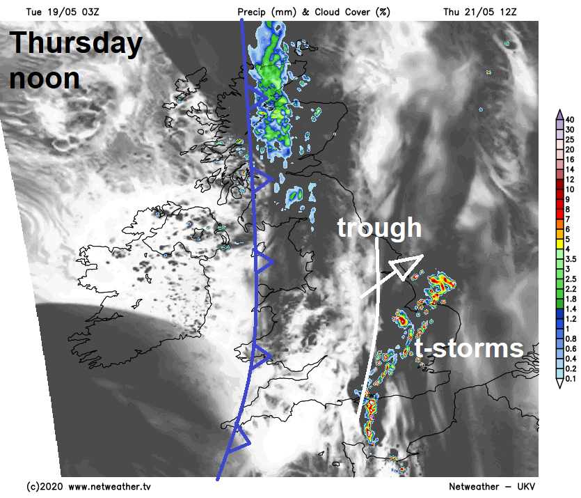
The settled conditions start to breakdown from the west on Thursday, with a cold front moving in across the west bringing a band of cloud and some showers across Scotland, NW England and perhaps Wales, cooler but drier and brighter conditions following from the west. Further east, warm and humid air hanging on across central and eastern England – where we will see some warm sunshine but also some thunderstorms breaking out from late morning into the afternoon, more especially across SE England, East Anglia up to Lincolnshire. Still warm away from the far west and north, temperatures reaching 19-22C widely, but across central, southern and eastern England 23-26C possible.
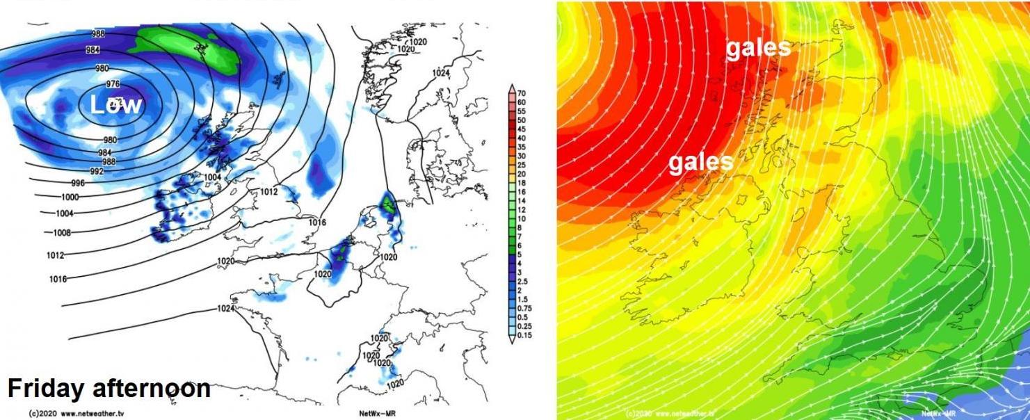
A more widespread change to cooler, fresher and windier conditions through Friday, as deep area of low pressure winds up to the west of Scotland. So will see southwesterly winds strengthen and a cold front will sweep east in the morning, not much rain along the front for southern parts, spell of heavier rain for northern areas. Following the front - drier, sunnier but increasingly windy conditions, with gales developing in the northwest – winds gusting to 50-60mph. Blustery showers moving in across Scotland, N. Ireland and west Wales too. Temperatures reaching 20-21C across eastern England, 15-19C elsewhere.
The weekend will stay unsettled and windy across the north, with further blustery showers, merging into a longer spell of rain across western Scotland on Sunday. Southern areas mostly dry, bright or sunny but breezy.