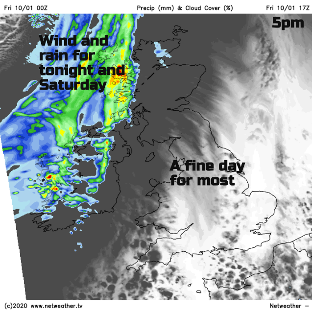
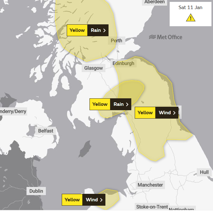
Friday looks fine and bright before the next spell of wet and windy weather arrives from the NW. More rain is not good news for areas on Flood alert with gusty winds for Saturday.
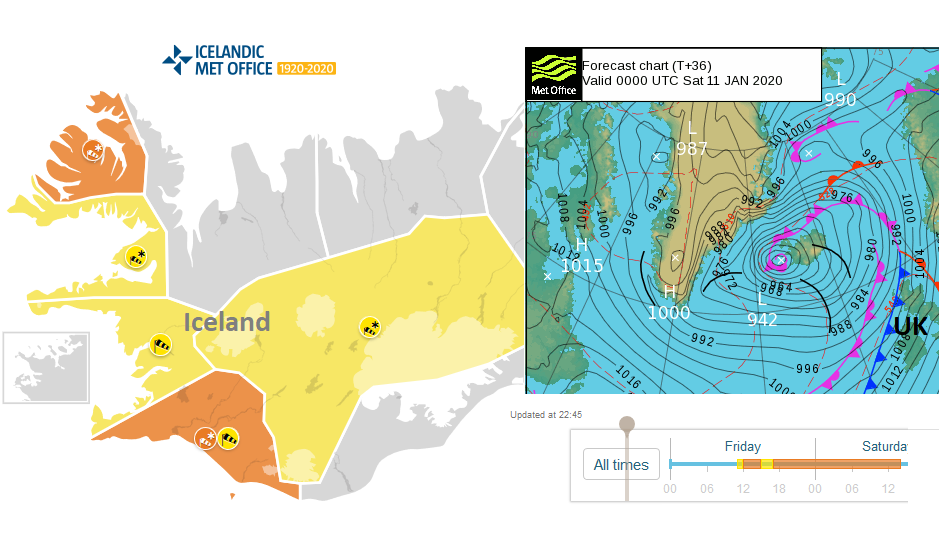
A fine day finally. The Azores high tries to nose into our UK weather today. Building in from the southwest, trying to say hello and settle our weather down, but it’s like trying to cross a busy road with low pressures whizzing by. The high makes it for one day, today Friday with fine, dry and bright conditions but then has to slide away over mainland Europe as a storm hits Iceland this weekend, affecting our UK weather. Next week there are more and more lows heading in, with a more wintry tinge to showers from the west.
Today
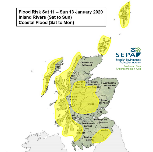
For most of the UK, it will be a fine, bright and dry day. There are one or two showers for coastal areas, but yesterday’s heavy rain has cleared. That was from a low pressure which skirted away to the south but managed to give southern counties of England a real drenching on Thursday. Flood warnings are in place on the Rivers Nene and Dene in the Midlands as levels rose sharply and there are numerous flood alerts from the Environment Agency. SEPA, the Scottish Environment Agency also has concerns for this weekend as the next system heads in.
The winds become much lighter for East Anglia and SE England during today with temperature up to 7C it will feel okay with sunny spells. Much of Britain will feel cool at 5C with a light SW to W wind but the winds will freshen during the day for Northern Ireland, much of Scotland and around the Irish Sea. So, it will feel cooler than the air temperatures of 4 to 6C.
As the frontal bands head in with patchy rain for Northern Ireland and blustery winds for the evening rush hour, it will turn wet for western Scotland where a lot of rain is forecast this weekend. As the southerly winds strengthen there could be lively ferry crossings for The Minch and western Scotland on Friday evening. Overnight the flow will bring milder air, so after a chilly Friday evening, Ireland and Britain will turn much milder during the night. Up to 11C.
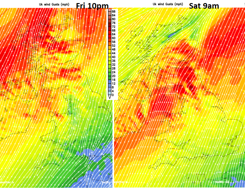
By Saturday morning much of England and Wales will start off mild, dry with bright spells and a fresh SW wind. The cold front heavy rain will be across Northern Ireland and Scotland with rain for Cumbria and ahead for Gwynedd. Within this zone, there will be fresh to strong SW winds with gusts around 60mph, over 70 for exposed areas so there could be some issues on the roads particularly for higher routes. To the north of the frontal band, the weather becomes clearer and colder but stays windy with a few showers for the far north of Scotland. It looks like the frontal band could wave, sending rain back north for a time or upsetting timings showing on your weather app. So just be aware that the rain may not clear when you expect it to, that is the uncertainty in tomorrow’s forecast.
During the afternoon the strongest winds will be for northern England and the northern half of Wales. The rain begins to clear from Northern Ireland but there still could be sharp showers from the north. A wet afternoon for NW Wales, the Isle of Man, northern England particularly Cumbria and the north Pennines. This frontal band slowly edges south into the north Midlands and more of Wales by Saturday evening as bands of sharp showers work their way down through Scotland. Ahead of all of this, the weather stays fair and mild but blustery.
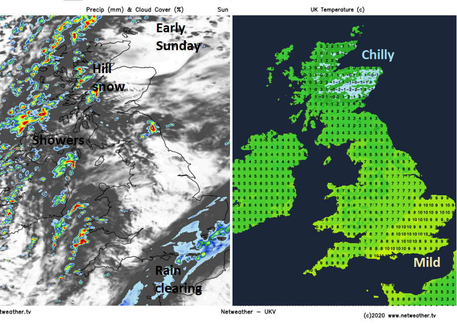
SE Britain has a mild night, NE Britain a chilly one. By Sunday morning the rain should be clearing away from London and Kent. This will leave sunny skies with a chill in the air although SE Britain should keep the milder air for the morning, up to 10C.
There will still be showers lurking, some heavy, some wintry with snow for Scottish Highlands. Keep an eye on the radar as these showers head east as one might catch you out on an otherwise sunny Sunday. During Monday the next bout of wet and windy weather barrels in from the Atlantic.