


Blog looking at the continuing onslaught of low pressure systems off the Atlantic, though slightly colder than recently - especially the north. Plus looking at any hints of cold and wintry weather on the way.
The New Year continues where December left off with outbreaks of rain or showers affecting all parts pretty much every day over the 7 days at least. The difference to the coming days as opposed to much of December is that the strong jet stream will be further south and tracking west to east rather than SW to NE, so we will see conditions cold enough across northern areas for snow at times, particularly, but not always exclusively over higher ground. It will be less mild across the south as well over the next 7 days, with temperatures reaching high single digits rather than low to mid teens that were commonly seen in December (though this is still slight above average). We will see areas of low pressure tracking east further south across the UK rather than NE close to NW Britain, so higher rainfall totals will be less concentrated on NW Britain, but other areas maybe more at risk of flooding.
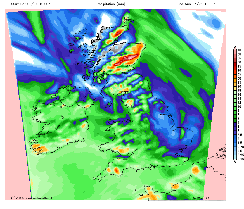
NetWx-SR rainfall accumulation forecasts 12z Sat - 12z Mon
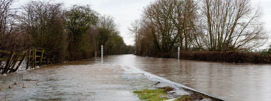
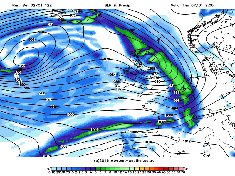
Over the next few days, there are concerns over forecasts rainfall totals for eastern Scotland, with an Amber Warning issued by the Met Office. It’s not so much the intensity of the rain that will be the problem here, but more the persistence. A slow moving frontal system lies across northern and eastern Scotland through much of Saturday and Sunday which, combined with a strong and moist southeasterly flow brings moderate but persistent rain from Fife and Perthshire up to Aberdeenshire, enhanced by the eastern upslope of Grampians inland. This near stationary frontal zone will be joined by another frontal system moving up from the SW Sunday evening, these fronts then loitering through Monday before retreating south by Tuesday. The Met Office are forecasting over 200mm in this area, there are 22 Flood Warnings for eastern Scotland, this morning there were 9, for more information refer to the Scottish Environment Protection Agency or SEPA website
Other areas of concern for possible flooding over the next few days are SW and parts of northern England, where there are number of Environment Agency Flood Warnings or Alerts, and also Northern Ireland. The amount of rain forecast to fall in these areas these next few days wouldn’t normally cause too many problems, but with the ground saturated and river levels already high to breaking point, it won’t take much more rain to bring flooding issues.
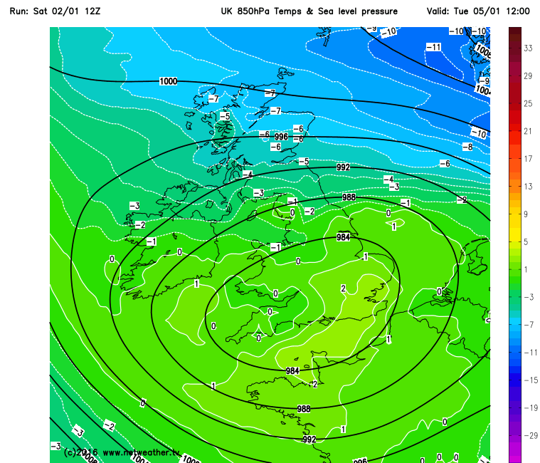
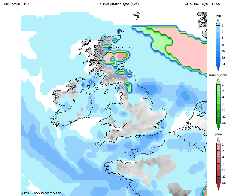
During Tuesday, an Atlantic low drifts slowly east across southern Britain, filling as it does so, before sliding across the N Sea and/or the near continent on Wednesday. The fronts around this low bringing bands of showers spiralling around it rather than anything persistent rain-wise. There is some very cold air over the other side of the North Sea over Scandinavia next week and we see some of this colder air being pulled west above this low across Scotland. So the showers here turning increasingly wintry, with a risk of snow – particularly but not exclusively over higher ground. Showers easing towards the east Wednesday, still wintry across eastern Scotland.
Deep cold air, as shown by the 850mb (in deg C) temperatures, will spread west across Scotland from Scandinavia, bringing sleet/snow showers:
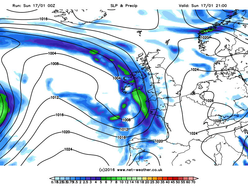
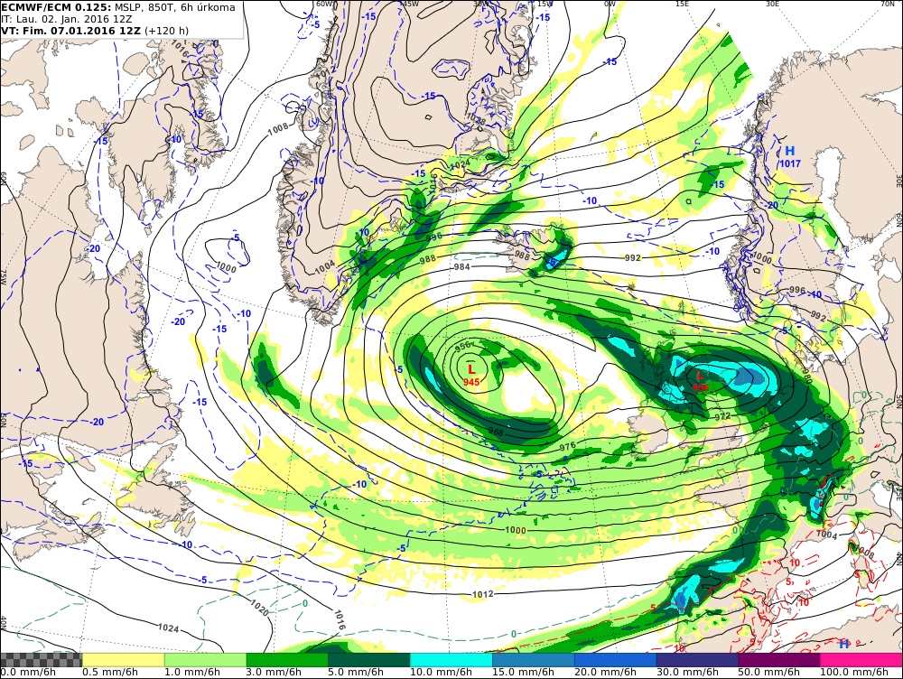
So there is a few days respite from more persistent rain after Monday, but the models indicate persistent and heavy rain returning from the SW on Thursday in association with a secondary low feature that moves NE around the flank of a parent low pressure system to the south of Iceland. Potential for this low to be quite deep, as it deepens before reaching the UK under the left exit of a strong 200mph+ jet streak racing across the Atlantic. Some uncertainty and exact track of this low, though 12z Saturday GFS, ECM and UKMO operational runs take a deepening low NE over northern UK, so here likely to see the heaviest rain. Potential for gales across central and southern areas. And with watercourses/ground sensitive to further heavy rain, more flooding is possible from this system – which could be named. As this rain clears, Polar maritime air following is indicated to be cold enough to bring a return of wintry showers with snow for higher ground in the north.
Potential deep low (maybe #StormGertrude) for Thursday as modelled by 12z ECMWF and GFS
The Atlantic onslaught will likely carry on beyond next week, with low pressure systems continuing to cross the UK. But with the jet stream and depressions continuing on a more southerly track, it will be cold in the north at times with a risk of snow, and feeling colder than recently across the south too. However, no sustained cold and wintry weather is appearing from the weather model output for now – certainly not nationwide. Given the lack of snowfall in the colder months for many since 2013, are there any signals pointing towards a UK-wide cold and wintry spell on the horizon? As ever, there are no guarantees, but there are few tentative indicators that may head us towards such potential.
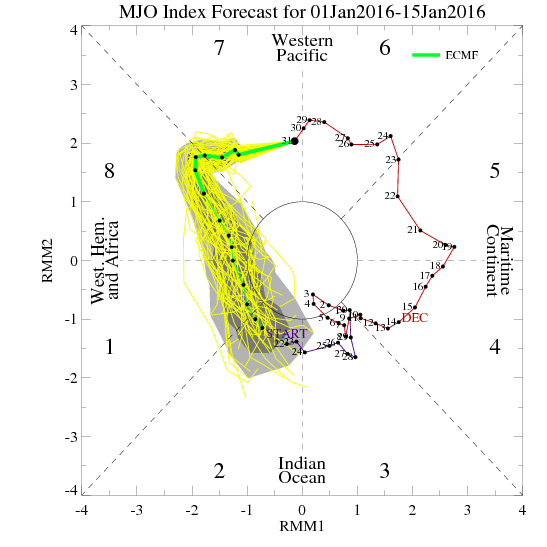
Firstly, a Sudden Stratospheric Warming (SSW), which can alter the tropospheric pattern where our weather happens and create blocking to increase cold, is more likely during El Niño (as now) and La Niña events. But this looks unlikely to occur until February now. However, the troposphere pattern, where our weather happens, may flip before in response to other drivers before any warming works down from the stratosphere. One of these drivers is the Madden Juilan Oscillation MJO - which is forecast to track through phase 7 at decent amplitude before losing a coherent signal through phase 8/1. Phases 7/8/1 are indicated to bring changes in wave patterns in the mid to high latitudes of the northern hemisphere, as the MJO wave travels east over the tropics, which can increase blocking which then leads to a higher chance of colder conditions across parts of Europe and/or N America.
Most recent MJO phase diagram from the ECMWF:
Also, the current strong El Nino itself will have an effect on upper flow wave patterns over time. The Nino warm anomalies over the central and eastern tropical Pacific are enhancing the low-level westerly flow here and increasing Atmospheric Angular Momentum (AAM) to an enhanced state. AAM is a measure of how fast the atmosphere is spinning relative to the earth’s rotation and high AAM can lead to an increase in poleward fluxing eddies which can cause amplification of the jet stream over temperate latitudes of the northern hemisphere – leading to a greater chance of blocking.with cold arctic air spreading south to N America and/or Europe.
So there are sound indications, at the moment, that suggest the seemingly endless onslaught may not last all winter, but there no guarantees I’m afraid.


