


A look at European Weather - First snow of the Autumn in eastern Europe and a risk of extreme rainfall in parts of southern Europe over next few days

Parts of eastern Europe have seen their first snow of the autumn on Monday, with reports of heavy bursts of snow Monday morning across southern Poland, bringing a couple of centimetres in the valleys and 8-10cm higher up. Some 10,000 homes in southern Poland experienced power outages thanks to wet snow bringing down power lines. Light snow was still being reported by METARs in Krakow and Katowice Monday lunchtime, with the temperature in Krakow only 1C with sleet falling at 5pm Monday evening.
Photos courtesy of twitteruser @Meteovilles
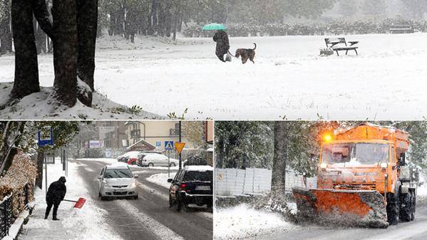
Moscow woke up to its first blanket of snow last Friday, as an unusually cold pool of air for early October plunged south across NW Russia between a deep low further east and high pressure over Scandinavia.
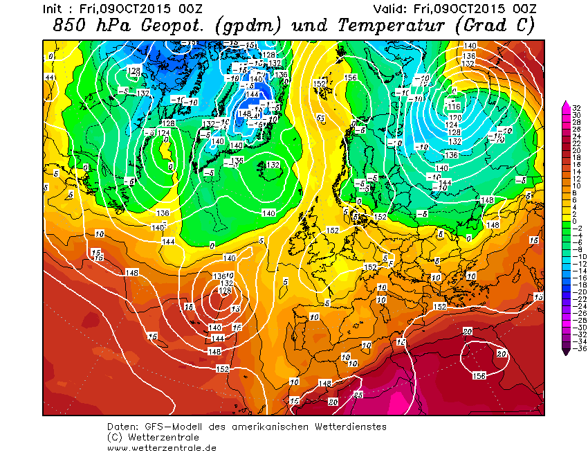
This cold pool of air over western Russia spread further west over the weekend and to start this week, thanks to the combination of the stubborn blocking high remaining over parts of Scandinavia and the Baltic Sea and low pressure sliding east across central and eastern Europe. An area of low pressure moving across Austria, Slovakia and Hungary on Monday brought an area of rain which turned to snow over parts of Slovakia and southern Poland on Monday, as it bumped into the cold air streaming west out of Ukraine. The layer of cold surface air currently over central and eastern Europe gradually easing through the coming week, as a slow-moving area of low pressure developing over northern Italy begins to mix out the colder air with milder air from the south.
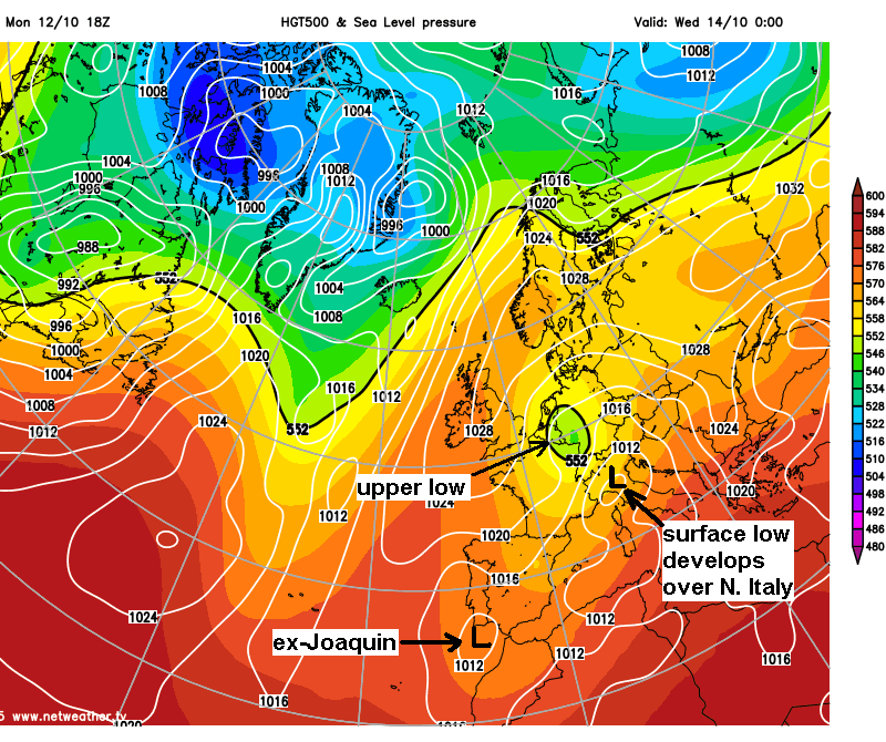
Looking in more detail at what’s happening synoptically, is quite a complicated picture for the rest of the week over Europe. An upper cold pool/upper low has dropped south across the North Sea overnight between a ridge of high pressure over the Baltic and high pressure over the north Atlantic. The upper low is across the Low Countries Tuesday and is modelled to become slow-moving while expanding across much of northern and eastern France, western Germany and Switzerland over the next few days, before dropping south across northern Italy by the end of the week. The upper low then drifts back north of the Alps across Germany and the Low Countries over the weekend.
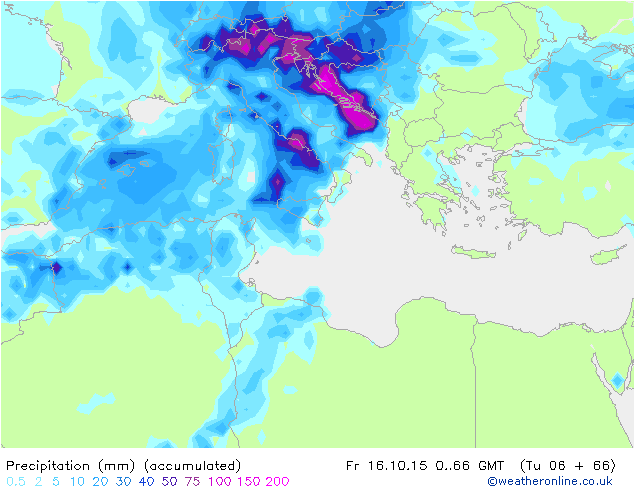
At the surface, the low pressure remnants of ex-Hurricane Joaquin centred close to SW Portugal will continue to bring rain or storms to the Algarve, southern and eastern Spain and northern Morocco today and Wednesday before drying up across SW Europe for the rest of the week. Further east along the Mediterranean, an area of low pressure developing over the Gulf of Genoa/northern Italy, at the base of the upper low slipping down over the Alps, will become slow-moving over the next few days before drifting east over the Adriatic and the northern Balkan countries to end the week. The slow-movement of the low over Northern Italy and countries bordering the Adriatic is a cause for concern. Sea surface temperatures are typically in the low 20s degrees centigrade around northern Med and Adriatic coasts, so warm moist air onshore flow, colder air arriving aloft from the NW and forced ascent from orographic uplift of the rugged coasts will create the ideal conditions for extreme rainfall events, with potential for 500-600mm (19-24 inches) to fall in some spots over the next few days. These large rainfall totals will lead to flash-flooding in prone areas. Northern and central Italy and Balkan countries bordering the Adriatic look particularly prone to these extreme rainfall events. So don’t be surprised to hear of floods in the news from these areas this week.
Surface low develops over northern Italy over next few days at base of upper low dropping south.
Large rainfall totals expected over Italy and around Adriatic (chart courtesy of Weatheronline)
The rain over southern Europe, as well as spreading east looks to expand north over the Alps into northern Europe later in the week too, bringing some heavy snowfall to the Alps (mainly above 1600m) and some snow to the higher parts of Germany and the Massif Central in France.
Snow accumulations over the Alps and higher parts of central Germany
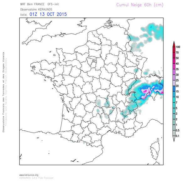
More snow for the Alps this week
Tending to dry up over Italy and eventually over the Balkans during the weekend, but as that upper low continues to drift north across northern Europe, we will see cloudy and wet weather expand north across northern France, the Low Countries, Germany, Denmark, Poland and the North Sea to end the week and through the weekend. This cloud and showery rain creeping across central and eastern England too over the weekend. Another low pressure system developing close to the Azores along a southern arm of the jet stream later this week looks to drift towards western Iberia over the weekend and early next week, bringing more wet weather to much of Spain and Portugal.
Looking further ahead, high pressure looks like being sat over northern UK/NE Atlantic to end the weekend and to start next week, with pressure lower over SW Europe and also central and eastern Europe. However, there is a big question mark over where the area of high pressure will drift thereafter, model ensemble consensus this morning sink the high south eventually ... with pressure dropping from the north. But this is a change from Monday’s guidance, so this is where the uncertainty exists.


