Hurricane Joaquin has battered the Bahamas, enhanced the torrential rain over the Carolinas and brushed past Bermuda. It now heads NW across the Atlantic, closer to the UK by the weekend
Tues 6th Oct update
Hurricane Joaquin brushed near to Bermuda on Sunday with gusts over 70mph, heavy rain and large swell affecting the Atlantic island. It's path NW keeps it far away from continental land, no warnings from the Canadian Met. Service and it will continue tracking towards W.Europe for the end of this week.
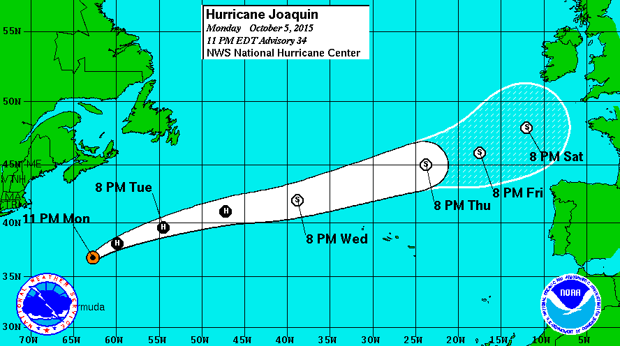
By then it will be an ex-tropical low, shown by the dark circles changing to a white circle on the path image from US National Hurricane centre. The Hurricane is now a category 1 system, the lowest on the Saffir-Simpson scale.
The UK Met Office charts now go out to Friday
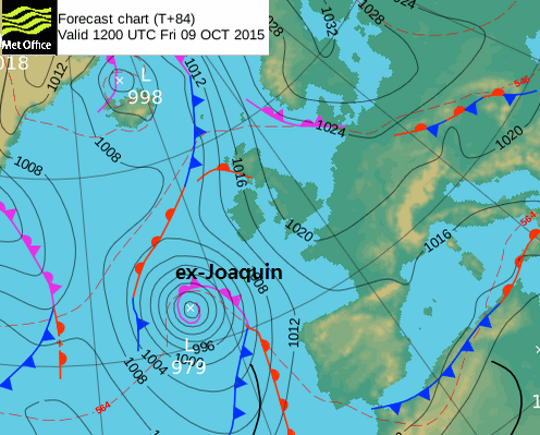
You can see the high pressure, which will build midweek, still hanging on over the UK, just in the east. The remnants of Joaquin lurking off NW Spain and closer to SW UK. Joaquin will have weakened as it moves over much colder waters, shear up through the atmosphere will pull the system apart but it still is one of the first lows of the autumn and it has tropical energy, and so is worth keeping an eye on. What could happen is that it stalls as it moves up against the high and lurks off NW Iberia bringing copious amounts of rain to say Galicia.
The NMM/GFS model takes the low centre closer to Ireland at the weekend and throws heavy rain over N.Ireland, Eire, Wales and SW England with strong SE Winds. It then tracks southwards into the Bay of Biscay, most peculiar.
So at the moment, Joaquin's effects look limited to whole of Ireland, Wales and W England, but still with low confidence that it will actually spoil the weekend for these parts of the UK. Further east looks more settled.
Thurs 2nd Oct
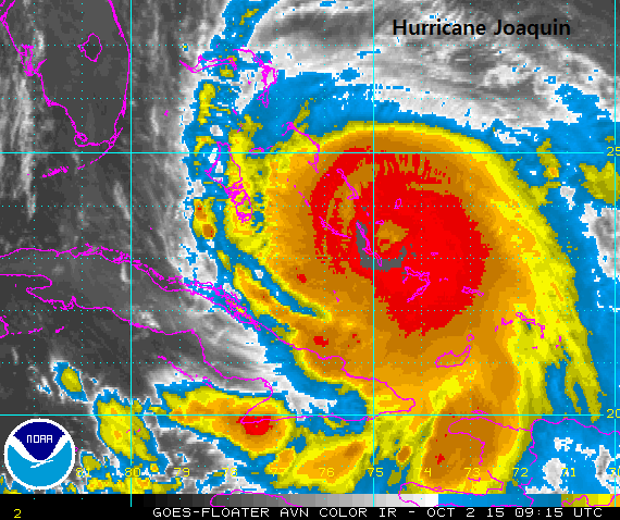
Joaquin has now been upgraded to a Category 4 Hurricane, as it continues to churn over the Bahamas. Reports coming in talk of 'major flooding has been reported in Exuma, Long Island, Cat Island and Eleuthera. However, the most severe flooding reported so far has been on Acklins, where power went off overnight limiting phone and Internet access. As many as 10 people were trapped on Samana Cay on Thursday, without proper shelter or communication.' Bridges and roads are underwater, the swell along the coasts is dangerous and the torrential rain and extreme winds continue for central and NW islands. Airports are closed on many islands, schools and offices shut and people holed up in shelters as Joaquin batters the Bahamas.
The latest National Hurricane Centre warning RAINFALL: Joaquin is expected to produce total rain accumulations of 12 to 18 inches over the central Bahamas with isolated maximum amounts of 25 inches. Rainfall amounts of 5 to 10 inches are expected over the southeastern Bahamas, with 2 to 4 inches over the northwestern Bahamas, eastern Cuba, Haiti, the Dominican Republic, and the Turks and Caicos Islands. This rainfall could result in life-threatening flash floods.
Joaquin will begin to move away from the Bahamas Friday night into Saturday (local time), with slow weakening expected from Saturday. However, warnings continue for rip currents, life threatening surf, large waves, elevated water levels with coastal erosion.
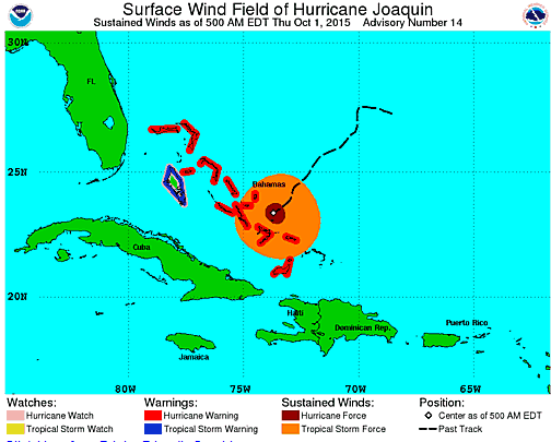
Joaquin centre east of Long Island, Bahamas 0915UTC 2nd Oct 2015
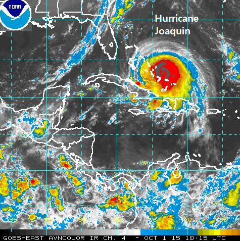
Weds 1st Oct
The eastern seaboard of the US is watching developments in the Caribbean, as Hurricane Joaquin begins to wind up. The Bahamian national emergency management agency are issuing advice to the Bahamas as Joaquin moves towards the central islands and is strengthening. Shelters are open as warnings for heavy rain, flooding, storm surge and large swells have been issued along with the winds. Hurricane Joaquin will batter the central Bahamas through Thursday night and Friday, moving over North-western islands on Friday.
For the eastern states any possibility of extra significant rainfall, is a big problem. Already many states have flood warnings in place; parts of Maine and N.Carolina have seen flooded states already this week. A system already over the Mideast is bringing heavy rain with more forecast into the weekend, even without Joaquin’s contribution. The presence of Joaquin away to the South is stalling the system bringing the heavy rain to theses states but any additional tropical downpours could result in widespread flooding.
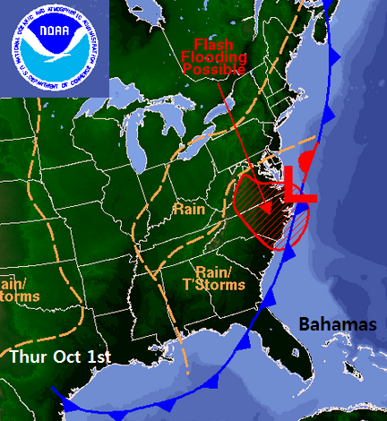
There is low confidence about the track of Joaquin, with paths varying from right out in the Atlantic, caught in the mid latitude westerlies and heading west of Bermuda, or striking the east coast US as far south as North Carolina or far north as Maine in New England. A nightmare for emergency and evacuation planners. Joaquin isn't likely to come near to the US coast until later in the weekend, or early next week. One to watch
Join in the Joaquin discussion and chat in the Netweather forum