Has July been overly wet and cool? Why does this summer seem to be stumbling along? A look at July's rainfall and the jetstream
Rainfall figures out today from the Met Office show much of the UK willl have had average rainfall for July. However some parts have been quite wet. The image shows rainfall from 1st -26th July compared to the 30 year average figures. You would expect about 86% to have fallen by the 26th in an average year.
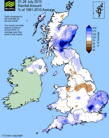
Looking at the map, most parts are white (around average) with a few parts of England and small pockets in Scotland being drier than average. However the Herts/Beds area stands out as being very wet, from the flash flooding after thunderstorms hit mid month, also affecting parts of East Anglia. These rainfall totals seem to have been mostly from isolated heavy thundery downpours causing the amounts to soar. Eastern Scotland also stands out with dark blue areas and was affected by torrential rain from thunderstorms mid month.
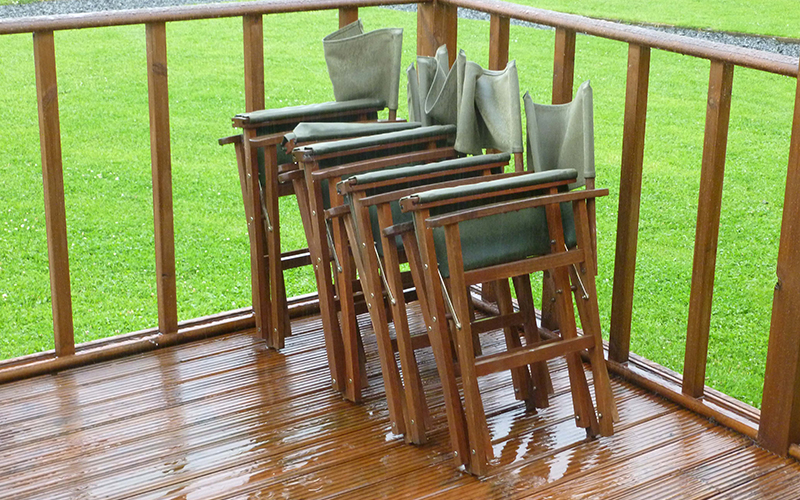
Most of the flow this month has been from the west, off the Atlantic, which would have left eastern Britain drier as you'd expect. Just the storms pushing over Eastern Britain have bumped up the totals. The last few days of July should see the persisten rain and heavy showers easing, it has been pretty wet for the northern half of the UK already this week. Southern Britain will be quite dry but another low appears from the NW on Friday to add to the July rainfall totals.
It's not been that warm either, especailly in Scotland where I am. Usually at this time of year, the jetstream (miles up in the atmosphere) is away to the northwest of the UK, closer to Iceland. As we well know, the weather isn't into averages and so there are always variations each year in the path and patterns of the Jetstream. Recently, it has been further south over the UK and has resulted in cooler air flowing in, with plenty of low pressures of the Atlantic. These bring wet and windy weather to the UK, which even southern Britain has been hit by this week, with a weekend past of heavy rain then strong winds. This can just happen, we get a great summer one year then the next one is different.
Lots of research is taking place looking at these changes, effects of climate change, we are currently in an El Nino strong event. NASA have announced that for 2015 the "Arctic Sea Ice Maximum Annual Extent is the lowest on record." Changes in sea surface temperatures could be important, the jetstream is driven by the contrasts of cool air in the north near the Arctic and warmer air further south
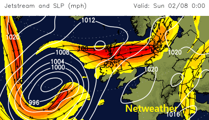
So today, Tuesday 28/07, we see the jetstream to the south of the UK, rain and showers over much of N.UK and cool air from the NW
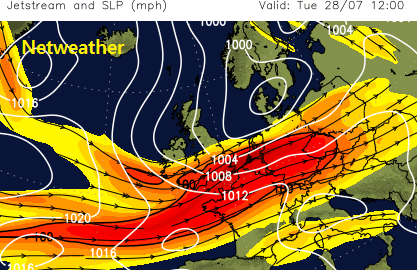
By the weekend the jetstream has shifted north a bit, with southern parts seeing some fine, slightly warmer weather but low pressure will still head in from the far NW bringing more unsettled weather. The Atlantic hurricane season hasn't thrown much into the mix so far this year. Next week may be different.