


Heavy rain, strong winds and gales. it's July and the weekend is upon us. A quick up date on what is in-store today,tonight and tomorrow morning. Check outside for what could blow away East Anglia.

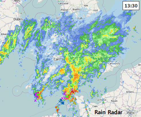
Heavy rain has already arrived over the West Country and S.Wales and will continue to march eastwards with heavy downpours forecast for SE Britain Friday teatime onwards. Conditions on many roads including the M25 will be tricky with poor visibility, surface water and spray and then strengthening winds for southern and eastern England. Netweather radar or try the App. Lightning in the Channel now
With schools now into summer holidays, this isn’t ideal weather for July. Saturday does improve but we have got a lot of wet weather over southern Britain to end the working week and gales for the early hours of Saturday buffeting East Anglia. The northern half of the UK does have some sharp showers for Friday but is avoiding the worst of the weather for once.
The low pressure bringing all this wet and then windy weather is heading eastwards today. So the heaviest rain will head towards London and SE Britain ready for the end of work. Waiting for the bus/short journey to the tube could result in a soaking.
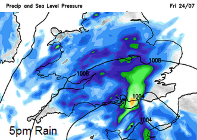
The image above shows the forecast rain for 5pm today, the blues are areas with rain but the greens and yellows show the areas of heavier rainfall. This is forecast to spreading over the Home Counties and into East Anglia. See the Netweather warning
This low continues to deepen and so the winds strengthen. Fresh to strong N winds will pick up over SW England, as the worst of the rain clears Devon and Cornwall this evening. The rest of the night will seem like mid autumn, cool, wet and blowy winds. As the English Channel becomes rough, the Channel Islands see strong winds and gusts 50mph. Overnight ferry journeys could be lively.
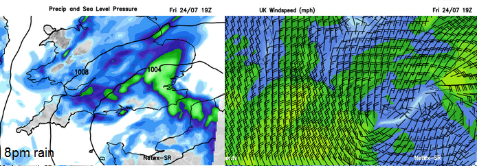
As the low really winds itself up tonight East Anglia and E. Lincolnshire, around the Humber will get hit with strong to gale force winds around the coasts and gusts around 60mph. The red area on the image below shows the area with highest gusts around dawn.
For Saturday morning conditions for Norfolk, Suffolk and Essex will be miserable as the wind and rain only slowly clear off into the North Sea. By midday Saturday the strongest gusts will have eased but it will remain windy for Eastern England into the afternoon.


