


There's a chilly easterly flow over the next week or so, a month ago it could have been the beast from the east, now it's more of a lamb, but it will still keep temperatures in single figures under a predominantly cloudy sky as high pressure dominates.
There's a chilly easterly flow over the next week or so, a month ago it could have been the beast from the east, now it's more of a lamb, but it will still keep temperatures in single figures under a predominantly cloudy sky as high pressure dominates.
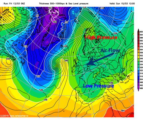
With high pressure strengthening over Scandinavia and spreading over the UK & Ireland, and low pressure over the Mediterranian, we're lined up for an easterly wind feeding in colder air from the east. It's not a high with blue skies and widespread crisp overnight frosts either, as there will be plenty of anticyclonic gloom around and occasionally the cloud will be thick enough for a few showers over eastern and south eastern areas. Any brighter spells will mainly be confined to western areas as we head throught the weekend and into next week.
Those clearer skies will see patchy overnight frosts for western areas, and by midweek the cloud will be breaking a little so we could see more widespread frosts as the high starts to shift west over the UK. This will allow milder air to make some headway from the Atlantic, lifting temperatures as next weekend gets closer and there's a good possibility of a touch of warm spring sunshine to end the week.


