


Latest Synoptic Analysis - looking at another troublesome depression moving through southern Britain tonight, bringing gales or severe gales and a wintry risk for northern areas.
We have another deepening low arriving across the UK tonight. It won't be quite as intense, extensive or as damaging as Wednesday's monster whose centre moved east way to the north of Scotland, but still had powerful impacts across the northern half of the UK. The embryonic stages of tonight's low was just an innocuous frontal wave mid-Atlantic at midday today, at around 1013mb. However, 12 hrs hence, the low undergoes RACY (Rapid Cyclogenesis) as a sharpening shortwave upper trough, that pushed SE from southern Greenland today, engages the baroclinic zone lying between Ireland and NE Canada. This frontal zone separates milder tropical maritime air to the south and colder polar maritime air to the north and the shortwave and divergence aloft in the right entrance of the strong jet stream causes a kink in the frontal zone to form a deepening wave and eventually a small secondary depression which will track east across the southern tip of EIRE, then southern Wales, Midlands before exiting somewhere around Norfolk or Lincs coast.
MetO fax chart for 00z Friday
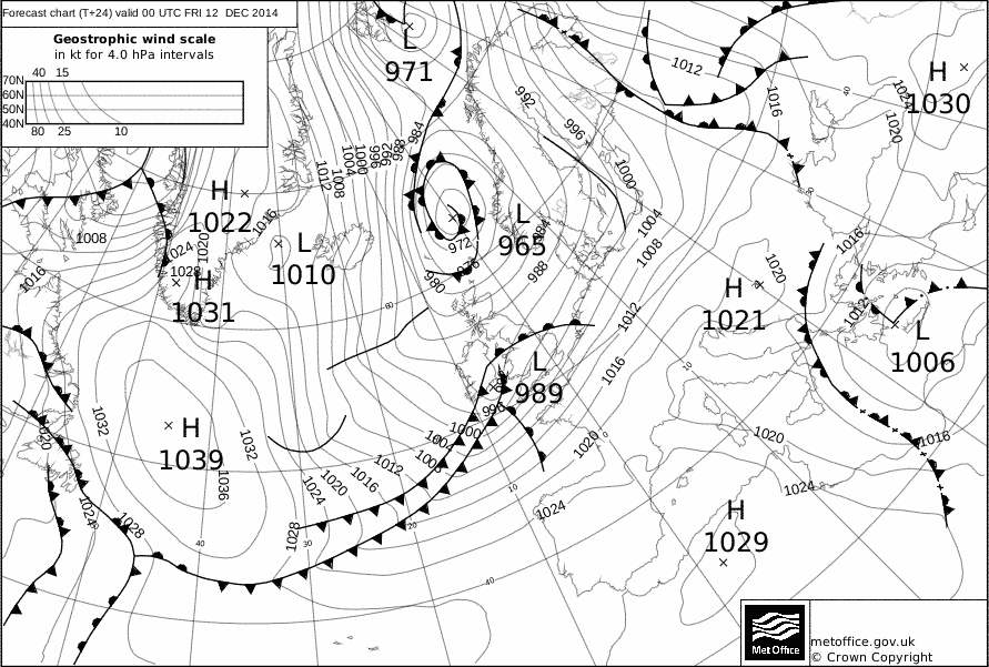
Met Office fax charts has the wave at 1013mb at noon today, at midnight tonight its 989mb, then midday Friday its 981mb. The Met Office definition of a weather 'bomb' is a 24mb pressure drop in 24hrs, so this low fits that bill. Although it's hardly of the same caliber as Wednesday's storm, it will still pack a punch of strong winds on its southern flank across southern counties of England. Peak gusts look to occur between midnight and 6am Friday morning, with gusts of 50-60mph across southern counties of England and parts of East Anglia, perhaps 60-70mph with exposure along the south coast.
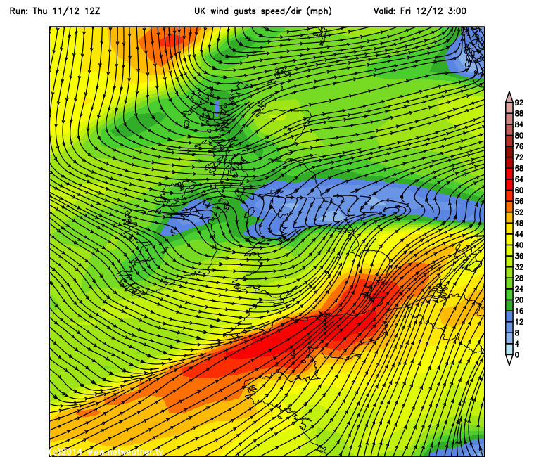
As well as the gales or severe gales across the far south later, rain already spreading east this evening ahead of the wave across EIRE, N Ireland, England and Wales will turn to increasingly to snow later this evening and overnight across higher parts of northern EIRE, Northern Ireland, North Wales and Northern England, as colder air cuts down from the north behind the wave low. Snow perhaps to lower levels at times too in these areas but maybe not settling or temporary, several cms possible accumulating over higher ground though. Further north. wintry showers already across Scotland and bringing snow to higher ground, will spread down across northern England and N Ireland/Nern EIRE later in the night/Fri morning as winds veer northerly in wake of the wave depression exiting into the North Sea. Some of these showers spreading south across Wales too, bringing some snow over the mountains. Significant falls are likely across the western Highlands.


