A preliminary look at various drivers that may shape the weather patterns through summer 2024 in the UK.
After several back-to-back wetter-than-average months, a distinct lack of sunshine and chilly conditions in the 2nd half of April, we’ve finally seen sunshine and rising temperatures this week, temperatures this weekend could reach 26-27C towards the southeast. So, with the feel of summer this week, many will probably be wondering what the UK summer proper will bring. After the relentless rain and dull weather since last summer, many are probably hoping for warm or hot and dry weather, but will there be a risk of more dull and wet weather?
The good news, for those hoping for a long warm summer, is that warm UK summers that occurred with a 1-in-5 frequency in the 1981–2010 period now occur with double that frequency. But that doesn’t rule out that this summer will be dud.
El Niño–Southern Oscillation (ENSO)
One of the first things we look at to construct a seasonal forecast is the forecast for ENSO. El Niño, the warm phase of ENSO, is the warming of the equatorial Pacific. It has been one of the main players in influencing global weather patterns over the last year, exacerbating background warming from climate change by adding additional warmth to the atmosphere. 2023 was the hottest year on record and the record warmth was boosted by El Niño conditions, on top of long-term human-caused climate change, and that warmth continued into 2024, in fact, the last 11 months have been record-breaking warm individually.
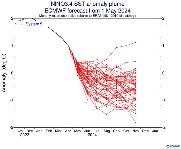
El Nino is rapidly weakening and will all but vanish by the time the summer season kicks into gear. But El Niño’s disappearance and likely arrival of La Nina, a cooling of the equatorial Pacific, doesn’t necessarily mean we won’t experience more record-breaking warmth this year, including this summer. Especially when the world is heating up due to human-driven climate change.
Source: Australian Bureau of Meteorology (BOM)
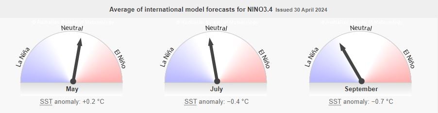
By June, it is forecast that equatorial Pacific Ocean temperatures will hover close to normal, marking a so-called neutral phase, before La Niña builds in early summer.
But the strength of El Niño or La Niña’s influence on global weather isn’t uniform and varies greatly based on the strength of the phenomena and the season itself. The influence of El Niño or La Niña on weather patterns isn’t as clear-cut in the summer as it is in the winter, especially during a transition between the two phases.
Temperature differences between the tropics and mid to higher latitudes are more extreme in the winter – which allows the jet stream to become quite strong and influential in driving weather patterns. In the summer, the difference in temperature isn’t as significant and the obvious influence on weather patterns wanes.
There has been some record-breaking warm summers during La Nina in recent years, 2022 was the hottest on record during the 3rd consecutive year of La Nina, the summer which saw 40C reached for the first time in the UK. So, we can’t reliably suggest that we won’t have record-breaking warmth this summer, because El Nino influence has gone. So, we need to look at other factors that may drive the season’s weather and could point towards a hot one, an average one or a cool one (unlikely!).
Other drivers affecting mid-latitude weather patterns that affect UK and Europe in summer
A number of studies have shown that Rossby waves emanating out of the tropics can influence the extratropics in summer that bring warm temperatures to the UK. Also, it has been suggested that changes in sea ice can also affect midlatitude summer circulation patterns, including over the North Atlantic/European sector. Sea ice anomalies in the spring season prior to hot summers show higher sea ice than normal in the Sea of Okhotsk and lower sea ice than normal in the Barents/Kara seas.
It is likely that influences from different remote regions are active or dominant in different years. The influence from the tropics has been demonstrated to be linked to tropical precipitation anomalies via extratropical wave trains. Circulation anomalies associated with wet conditions in the Caribbean project particularly strongly onto the hot UK summer conditions, with a weaker signal from the tropical Pacific consistent with developing La Niña.
Anomoulously warm sub-tropical North Atlantic
Another thing we are looking at, that could influence and shape the weather patterns over the North Atlantic through the second half of the summer season, more particularly August, is strengthening La Niña conditions, coupled with sub-tropical North Atlantic ocean temperatures which have been at record highs for over a year. There has been plenty of speculation that this will supercharge the Atlantic hurricane season – which starts in June but peaks from mid-August through to mid-October.
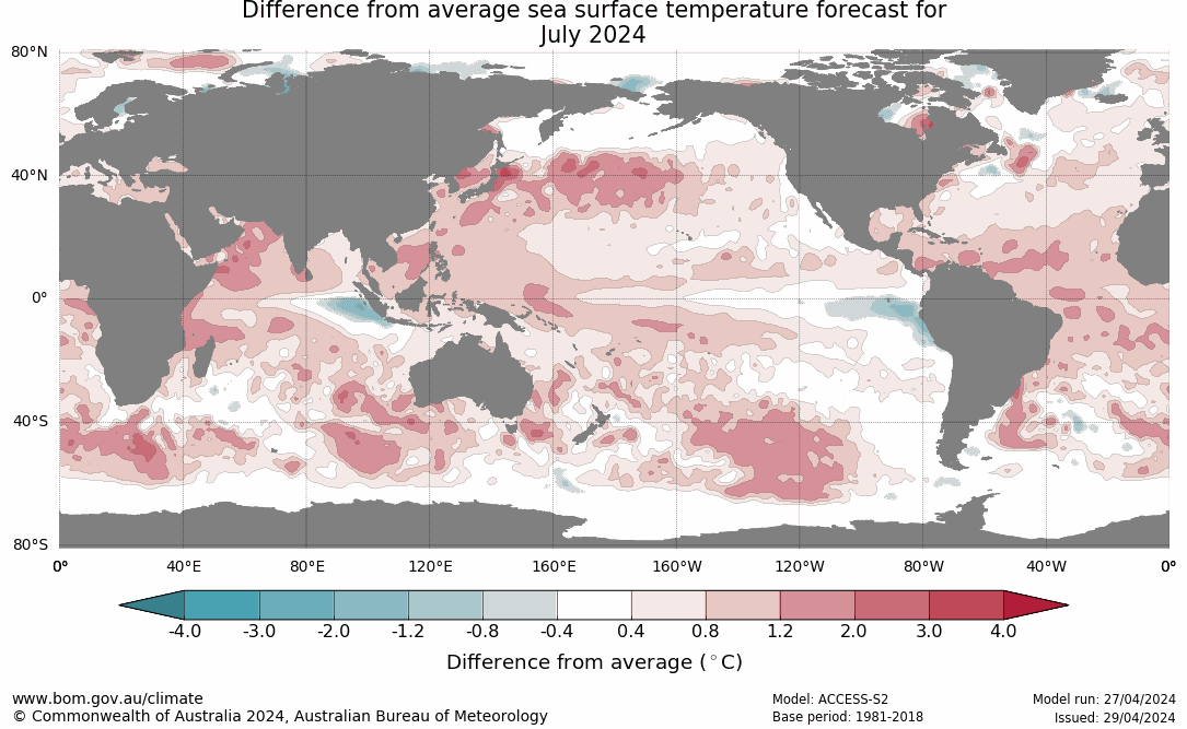
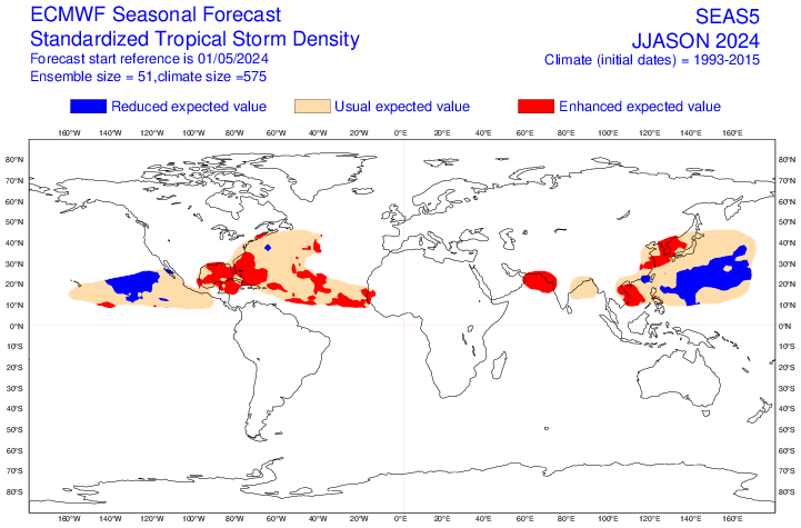
Enhanced Tropical Storm activity forecast over the tropical N Atlantic could influence mid-latitude weather patterns later in the summer. Source: ECMWF.
But the anomalously warm sub-tropical North Atlantic ocean can also more directly influence Europe’s weather through enhancing surface temperatures and also stable pressure patterns. A marine heatwave in the Atlantic Ocean in June and early July 2023 was thought to be a contributing factor in bringing the European heatwave in July last year. The marine heatwave likely affected atmospheric circulation patterns and also warmed up the airmasses above them. With the anomalously warm ocean temperatures between northwest Africa and the Caribbean likely to persist into the summer, further marine heatwaves could trigger ‘heat domes’ to expand over NW Africa and in across southern Europe, perhaps expanding north to the UK at times too. This weather pattern allows a warm air mass to build up under a high-pressure system, creating stable and dry conditions.
Analog composites
Years with similar El Nino to La Nina transition: we can use previous years (analogs) where similar Oceanic Nino Index (ONI) decreases were noted between the previous winter and the upcoming summer. 1998 is a strong analog year: going from a strong El Nino to strong La Nina in the same year, the Nino last winter was very strong/strong. We can add 2016, 2010, 1995 for a drop from Nino to Nina in the same year too. We may use years prior to the 1990s too, but to problem is going too far back is that global warming has increasingly skewed atmospheric circulations, making analogs less useful.
What the weather model seasonal forecasts show:
So far, we only have ECMWF seasonal forecast that has updated this month, so we will examine the forecast trends from this model. ECMWF is statistically a better long-range model, so it’s a good starting point, the rest of the model seasonal forecasts should update in the next week, so will look at those at a later date before the summer forecast is issued.
Looking at the ensemble mean anomaly for 500 mb heights, it shows lower heights over Greenland and Iceland generally for all three summer months, higher heights over western and central Europe.
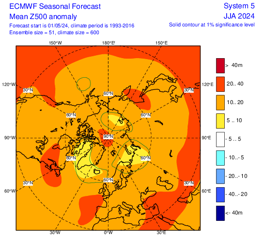
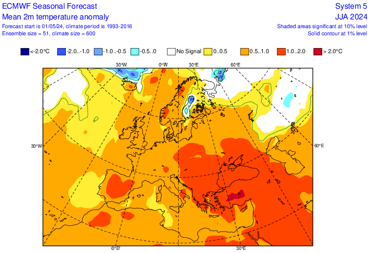
The above 500 pattern is generally one that suggest a jet stream north of the UK and warm pattern for the UK and this is reflected in the temperatures being 0.5-1C above average for all 3 months.
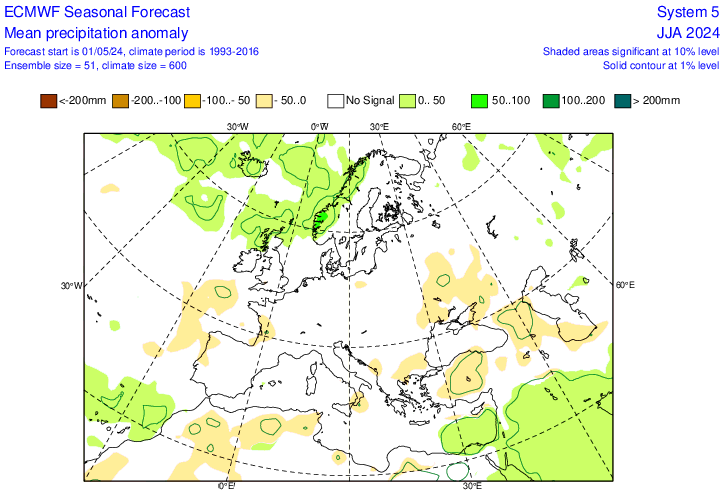
Rainfall highest towards the north, lowest to the south, which ties in with higher heights / pressure towards the south. Generally there is no rainfall signal that’s wetter or drier than normal the UK for all 3 months.
Conclusion
Most signals point to a warmer-than-average summer is most likely, perhaps not record-breaking heat like 2022, but that doesn’t mean we may not see one or two spells with high temperatures perhaps reaching the mid-30s. Rainfall, many will be glad to hear, doesn’t look to be excessive, no signal for too wet, away from the far north nearer the jet stream, average amounts, though some dry periods and wetter period in the mix to get the average.
The full Netweather Summer Forecast will be issued later this month.