Storm Babet, an atmospheric river and wild spring tides. October 2023 saw disruptive flooding, a record for eastern Scotland, coastal damage and widespread sodden ground
It has been very wet this autumn for much of the UK. Anyone in eastern Scotland would not be surprised to learn that the region had seen its wettest October on record. Scotland bore the brunt of an early 'atmospheric river' event and then Storm Babet later in October. Some counties saw twice their monthly rainfall amount and several counties in the east of Scotland recorded their wettest October on record.
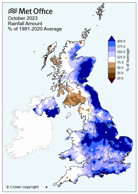
The UK saw 40% more rain than average in what was “provisionally the joint-sixth wettest October on record”. It wasn’t a record breaker due to rain shadow effects in an unusual wind direction. These kept the usually wet northwestern areas, relatively dry. You can see the brown colours on the map above. The UK forecast for the week ahead keeps a more usual east-west split with lots of heavy showers for western Britain and Northern Ireland but a fair bit of shelter for eastern parts.
Northern Ireland saw 68% more rain than average with its fifth wettest October on record. Other counties also had their wettest October month on record: Staffordshire, Nottinghamshire, the Isle of Wight, Co.Armagh and Co.Down
Many parts in the east of Scotland, England and Northern Ireland have already seen more than their average rainfall for the whole season of autumn (for statistical purposes Sept, Oct, Nov). A few locations have seen as much as 150% of their seasonal average with a month still to go. Storm Ciaran will be part of November’s figures.

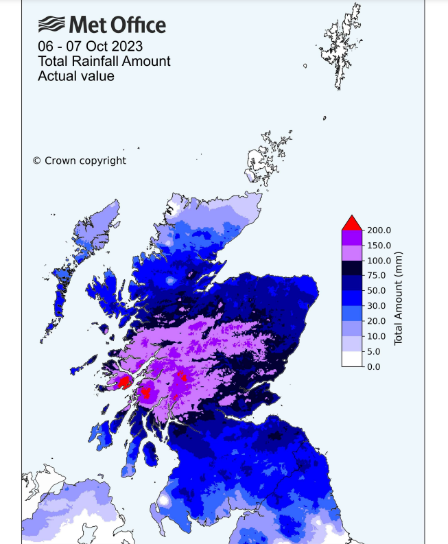
It may be tricky to remember early October but Scotland was hit by an ‘atmospheric river’ which resulted in the wettest 2-day period on record for Scotland (records back to 1891). High pressure over France and southern England kept that region dry, sunny and warm as a feed of moisture-laden air affecting the north of the UK. This frontal zone marked a contrast between cold air in the north and warm air in the south with temperatures into the low 20sC, even reaching 25C in the southeast.
There was widespread and prolonged rainfall in Scotland on the 6th and 7th of October. It was exceptional with 100-150 mm of rain falling over southern, central and eastern areas.
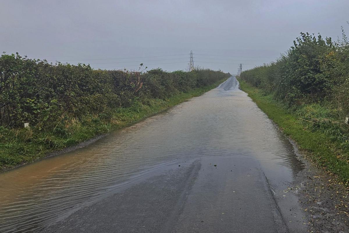
This rainfall led to a very wet weekend with many people just, staying at home. There was travel disruption and landslides in western Scotland. People had to be airlifted from the notorious A83 as mud came down the mountainside in the persistent rain. Saturday 7th sporting fixtures were abandoned and fields flooded.
This phrase “atmospheric river” is more often heard for California, and has wreaked havoc along the west coast of the USA. It is the continuous flow of moisture which gives huge amounts of rainfall to a specific geographic area,

Another seasonal effect is a stronger jetstream. At this time of year colder air starts to appear in continental North America but there is still plenty of warm air further south. That contrast also kicks the jetstream into gear and deep autumn low pressures develop across the Atlantic, heading our way.
So, it was a wet month anyway with the exceptional rain early on, then Storm Babet hit and this was a major rainfall event. October saw a lot of rain off the North Sea, an unusual direction for days of heavy and persistent rainfall. And it kept on happening.
The ground became sodden, there were flood warnings and more heavy rain appeared, the problems just grew. Flood warnings carried on for days and eastern Scotland seemed to never be without a weather warning for more rain.
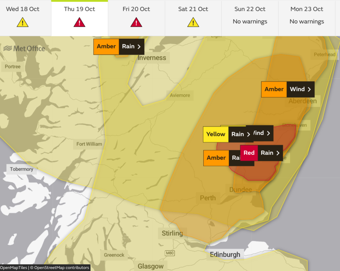
The main part of Storm Babet was between Weds 18th and 21st October 2023 although travel disruption and flooding continued well into the next week. It will be remembered for its rainfall but there were also strong gusty winds. The Met Office issued two red warnings for rain and this event helped the overall October totals.
The last time the Met Office issued a red warning for rain was from storm Dennis in mid-February 2020, covering parts of South Wales. In 2020 ,the wettest day ever recorded across the UK occurred in Storm Dennis but was then beating October that year on Sat 3rd both beating a UK record from August 1986. Quite a variation in months.
It is a rare occurrence to see a red Rain warning, when the impacts of severe weather are expected to be high. However as the atmosphere warms, due to human-induced climate change, it can hold more moisture, at a rate of around 7% more moisture for every degree of warming.
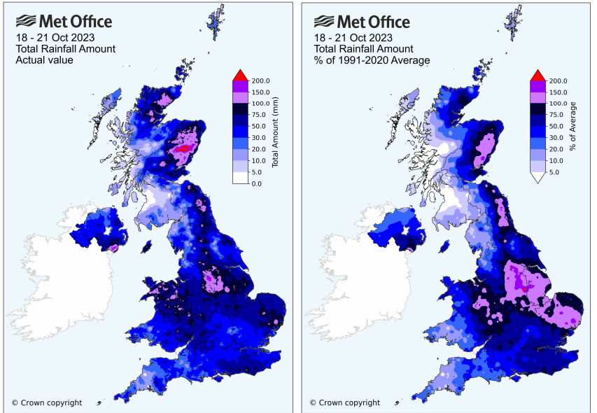
Angus saw its wettest day on record, in a series from 1891, on 19 October 2023 thanks to Babet. Large swathes of the UK received over 50mm of rain (2”). For eastern Scotland, the Pennines, North Wales, the Mourne Mountains of Northern Ireland and parts of the West Midlands, East Anglia and south-east England there was 75 to 100mm (3-4”) and over 100mm in the wetter locations. A significant area of eastern Scotland saw location totals of 150 to 200mm (6-8”). “The Midlands provisionally recorded its wettest 3-day period on record. “MO
The Environment Agencies, local councils and emergency responders had a very busy time and several people died from raging torrents, falling trees and expansive flood waters. The River Trent responded slowly and there were still rising river levels downstream and new flood warnings on the following Tuesday.
“Atlantic storm systems affecting the UK in the autumn and winter months normally track west to east, driven by the jet stream, clearing eastwards fairly quickly. In contrast, this storm was on an unusual track from south to north, enabling it to pick up additional moisture as it crossed the Bay of Biscay. Babet was also unable to clear eastward into the North Sea due to a blocking area of high pressure across Scandinavia. The rain-bearing fronts therefore remained stationary across eastern Scotland for a prolonged period” Met Office
The wettest day of this period was 19th October, with some exceptional daily totals including 168.4mm at Waterside, Glen Esk and 151.6mm at Invermark Bridge (both in Angus) and 131.8mm at Charr (Kincardineshire) from the persistent heavy rainfall. Usually, it is the southwestern side of the Grampians that sees the heaviest rainfall with rain shadow effects further north or climatically drier east. In this atypical flow, the orographic enhancement was on the eastern side of Scotland and the rivers carried the water down to places such as Brechin.
It was a reversal of the usual rainfall climate patterns for Scotland and other parts of Britain
In England, more rainfall records fell, wettest October day on record; 61.4mm at Sheffield on 20th (139 years), 46.8mm at Waddington, Lincolnshire on 19th (76 years), 45.8mm at Lyneham, Wiltshire on 19th (66 years), 48.2mm at Wattisham, Suffolk on 19th (63 years).
This week the jetstream looks to lose its great meanders and with a more zonal flow, there will be showery weather whizzing in from the west and shelter further east. It will be blustery, Wednesday looks windy everywhere with a heavier band of frontal rain sweeping across the UK. The air is cooler now and there will be a bit of snow for the mountain tops, a few flurries over the higher hills of western NW England and Northern Ireland, all from the west.
“Local ongoing flooding is expected from rivers across parts of Sussex and Kent today (Monday) and also possible in the Norfolk Broads. Further local flooding from surface water and rivers is possible today across parts of Lancashire, Liverpool, Manchester and Cheshire and also in the South East of England on Wednesday following further rain. “Environment Agency Mon 6th Nov
It’s when our weather gets stuck that we get big problems. The atmospheric river early in the month was around a high to the south. A blocking high over Scandinavia prevented Babet from clearing away and resulted in atrocious weather conditions and significant flooding. With significant Spring tides for the last weekend and wild conditions along many coasts, October 2023 will be remembered as a very soggy, grey month.