Irma moves toward Florida having left a trail of destruction across the Caribbean.
The images are shocking of the trail of destruction left by Hurricane Irma as it rampaged across several Caribbean Islands during the week, leaving at least 23 dead and thousands homeless. Some of the islands it struck, such as Barbuda, Anguilla, St Martin and St Barthelemy have been left barely habitable. Some 95% of properties in Barbuda have been destroyed, for example. The low-lying Turk and Caicos Islands along with Puerto Rico also sustained extensive damage.
Destruction caused by Irma to the island of Barbuda
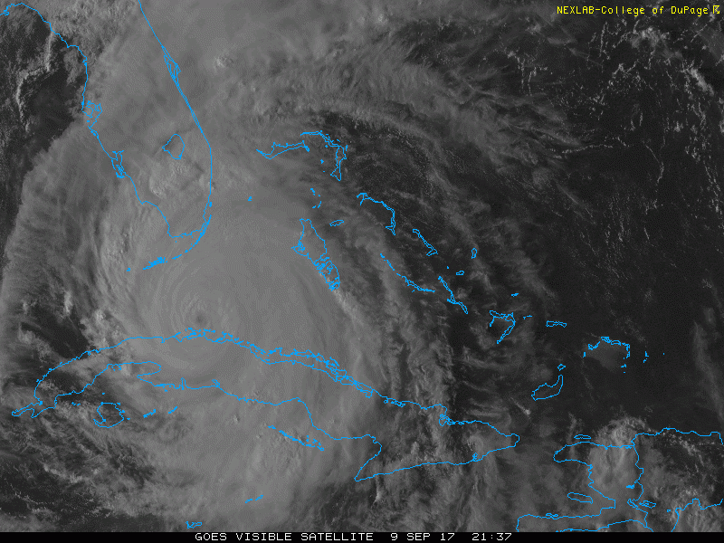
The latest victim is Cuba today, Irma made landfall in the northeast of the country as a category five hurricane. The first time a cat. 5 Hurricane has hit Cuba since October 1924, with scenes of devastation now coming in on news feeds, but not reports of injuries or deaths as yet. Irma has now weakened to category three storm, with 125 mph sustained winds, as it continues to move along Cuba’s mountainous north coast for a few more hours, before turning north towards Florida. Irma is then expected to strengthen again over open waters before making landfall across SW Florida on Sunday.
Some interesting statistics on Irma during its rampage across the Atlantic and Caribbean over the last few days, some record-breaking:
Irma has spent 3.25 days as a category five hurricane, tied with 3.25 days that Cuba (1932) spent as at cat. 5.
Irma is the 2nd strongest hurricane on record in entire Atlantic Basin, after Allen in 1980 – which brought 190mph winds.
Irma sustained 185mph max winds for 37 hours, the longest any cyclone in the world has maintained winds that strong.
For more statistics on Irma - read here
Attention now turns to Florida, with Hurricane Irma, currently cat. 3 as of Saturday evening, moving north from the Cuban coast over the warm waters of the Florida Straits and likely intensifying. Irma is forecast to strengthen into a Category 4 hurricane when it makes landfall initially across the Florida Keys and then the southwest of the Florida peninsula on Sunday morning. Wind gusts over 140 mph in these areas can be expected during landfall, leading to a swath of catastrophic damage, including life-threatening wind, storm surge and flooding rainfall hazards.
The outer rain bands of Irma moved onshore in southeast Florida today, bringing squally wind gusts between 45 and 55 mph and heavy rain with thunder and lightning along with a risk of tornadoes too. Conditions will continue to deteriorate rapidly across southern Florida tonight, initially across the Florida Keys, and will turn life-threatening into Sunday. Rain and hurricane-force winds will intensify quickly.
The centre of Irma is expected to track north along the western side of the Florida Peninsula, with greatest storm surge, up to 10-15 feet, likely near or just east of Irma’s eye, putting the Florida Keys and SW Florida Peninsula at greatest risk of inundation. However coastal flooding from a storm surge of 6-10 feet is likely along the Gulf coast of Florida as far north as Tampa, 3-6 feet as far north as the Florida Panhandle and all along the Atlantic coast on the eastern side of Florida.
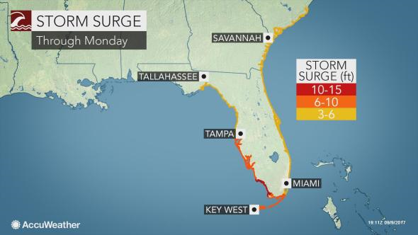
credit: Accuweather.
Much of southwest Florida could see wind gusts between 120 to 160 mph, the rest of western Florida gusts of 80-120 mph, while eastern Florida, including Miami, spared the highest winds, but still potential here for 80-100mph winds – which will cause damage to property and power outages.
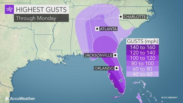
Credit: Accweather
In addition, rainfall from Irma could average 10-15 inches across much of Florida, with locally higher amounts, which may lead to significant inland flooding issues.
And if you thought nothing could approach Irma, Hurricane Jose further west and approaching the Leeward Islands is now a category four hurricane with sustained winds of 145 mph, stronger than Irma, which is currently a cat. 3 with sustained 125mph winds. Fortunately it looks like the worst of Jose will spare Barbuda, as it moves away from the northern Leeward Islands over next 12 hours.