Looking back at a warmer but wetter than average summer for the UK, and also looking across the Atlantic as more hurricane trouble brews.
Despite a seemingly cool and, at times, wet August, the UK was a mere 0.3C cooler than average and all regions seeing close to average rainfall up to the 30th, though Scotland and N. Ireland saw 122% and 129% average rainfall respectively - according to figures published by the Met Office today.
The summer, as a whole for the UK, was warmer than average, 0.41C above the long-term average. Though over the regions this varied between 0.85C above average for East Anglia to 0.01C above average for northern Scotland. Although there has been some cool weather at times this summer, especially over the last month, the fine and hot weather in late June and early July helped this summer’s average temperature be warmer than average. On June the 21st, the UK saw its hottest June day since 1976, with 34.5C recorded at Heathrow. This came in a hot spell where there were over five consecutive days where the mercury hit 30C or over for the first time in June since 1995.
But summer 2017 may be remembered by some as wet at times, and indeed many areas exceeded their long-term average rainfall over the three months of June, July and August – though parts of the Midlands were drier than average. The Met Office state that this summer is the 11th wettest on record over the UK as a whole.
TD Harvey
Rescues continue for people affected by Harvey, which has now been downgraded to a tropical cyclone and is moving NE towards Kentucky, but has cost at least 31 lives, forced 30,000+ people from their homes and caused, from some estimates, $190 billion-worth in damage across Texas alone. Parts of Houston, the United States’ fourth largest city, may be uninhabitable for weeks or even months, due to flood damage, mold, sewage and associated disease threat. All the threat of heavy rain for SE Texas and SW Louisiana, which bore the brunt of Harvey earlier this week, has ended, there will continue to be a threat of life-threatening flooding as flood waters continue to drain into water courses over the next few days.
Although Harvey has now weakened into a tropical cyclone as it finally tracks northeast, it will continue to bring heavy rainfall of 3-6 inches, isolated 10”, with a threat of flooding from Louisiana across parts of eastern Arkansas, northern Mississippi state, Tennessee and Kentucky on Friday and through Saturday, before it blows itself out on Sunday and the rain eases.
Hurricane Irma
Hurricane Irma formed quite rapidly in the far east Atlantic on Thursday as a category 2 storm and has now become a major hurricane this evening, perhaps becoming a category 4 or 5 storm next week.
Current trajectories take it WSW, which is fairly unusual for a hurricane here to lose latitude, as they have a tendency to recurve NW then eventually N, though some long-range models and their ensembles do recurve Irma either N and then NE off the eastern seaboard or, more worryingly, up across Florida and other SE states of the U.S.
But for now, it’s a fast-forming hurricane and certainly the windward Islands of the Caribbean and/or Dominican Republic/Haiti and eventually Cuba may be in the firing line next week, but with some uncertainty on exact track for now.
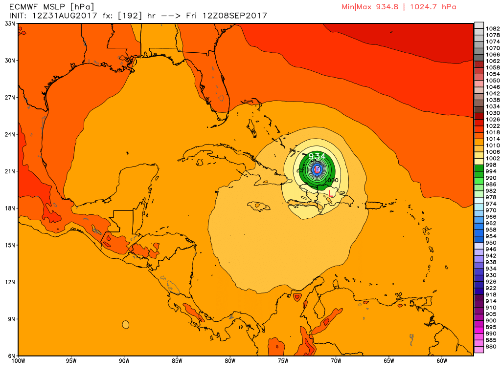
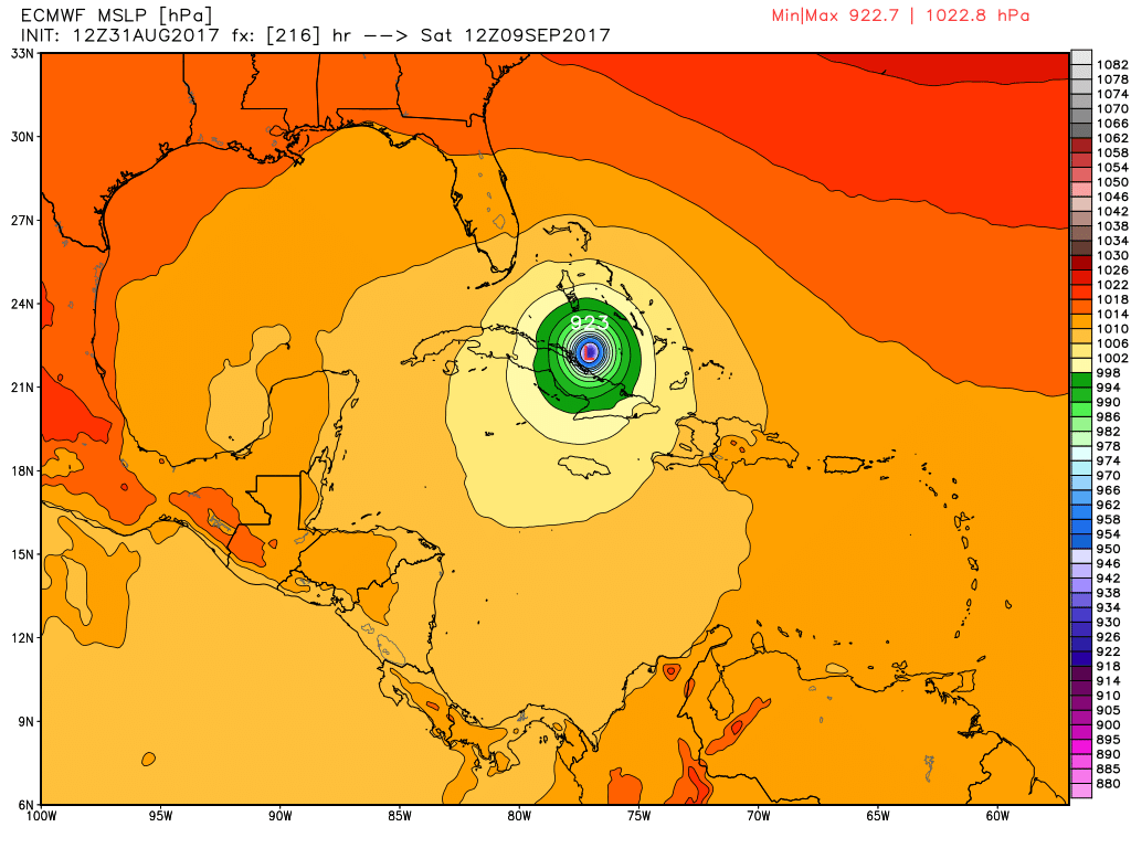
12z ECMWF model run Thursday evening takes Irma close to the north coast of the Dominican Republic then Cuba next Friday Saturday. But track is far from certain beyond this weekend.
Other tropical disturbances to keep an eye on over the Atlantic