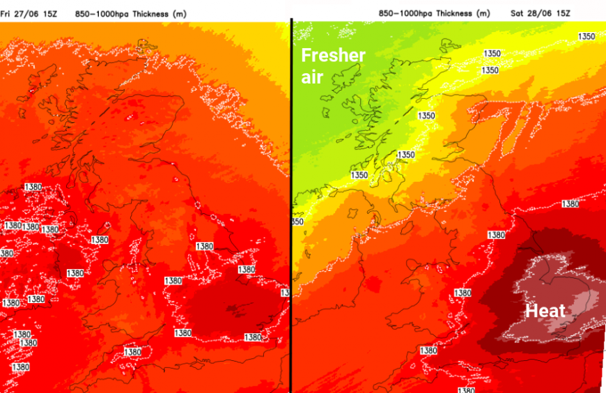
Another balancing act this weekend. Blustery, fresher conditions in the far northwest but growing heat for England as another heatwave episode looks likely.
Later this week, the heat and humidity will return after a brief lull on Thursday. It will be central, southern and eastern England seeing the highest temperatures, potentially reaching 30C with some areas qualifying for a heatwave. Further north and west, it will be a different story. Anywhere seeing spells of sunshine will feel warm but there will be fresher air arriving from the Atlantic for Scotland and Northern Ireland.
Friday
On Friday, there will be warm and humid air sweeping right up through the UK but with a moderate to fresh southerly wind. As this veers to the southwest, the sunny parts of England and inland Wales will heat up into the mid to high 20sC. For areas further north to the lee of high ground, like NE Scotland, here temperatures could move in the low to mid 20sC if there are cloud breaks for the sunshine. The northern half of the UK will see bouts of rain from frontal bands moving in from the Atlantic. It will be a mixed day with bands of rain, blustery winds and then breaks with warmth and a close, muggy feeling. The rain may reach into northern England and even western Wales could see more cloud and a little rain at times.
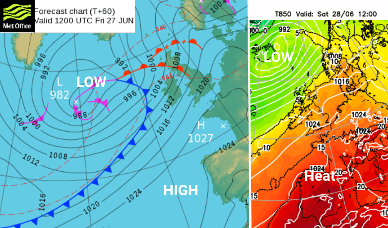
Northern parts of the UK are dominated by a low pressure to the north with blustery winds from the Atlantic
As the low pressure south of Iceland continues its path eastwards, a frontal boundary will trail back over Britain. This will be important through the weekend. To the south of this divide there will be very warm and more humid air. It will be dry, often sunny thanks to the high pressure over France. The wind will be from a WSW direction and the temperatures will be in the mid to high 20sC.
France has been experiencing heatwave conditions throughout this week with midweek thunderstorms.
To the north of the frontal band, it won’t feel so close, a change from Friday, but again there will be higher temperatures to the lee of high ground. Eastern Scotland will do well with temperatures of potentially 25C in places.
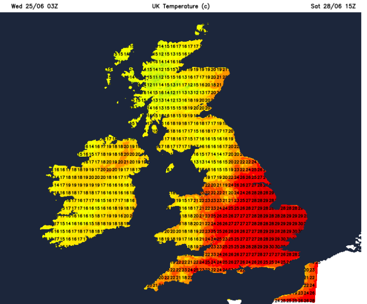
Saturday
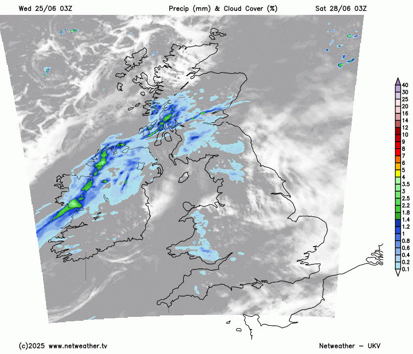
The frontal band will bring rain early on Saturday to Northern Ireland and Central and Western Scotland. This band of cloud and increasingly patchy rain will edge southwards and fizzle during the day. There is some variation amongst the models about how far south it will get but it looks like northwest England will see more cloud and a bit of rain on Saturday morning. Belfast, the Isle of Man and NW Wales could all see grey skies for a time with a bit of rain. The UKV model keeps the rain over Cumbria into the Pennines but other models move the rain down towards Lancashire in the day. With a brisk breeze off the sea, it won’t feel great for Anglesey or Blackpool but do wait to see where the rainband ends up.
There hasn’t been a lot of rain this month for central/eastern and southern England after the dry and sunny spring. The risk of wildfire spread remains very high this weekend, something to think about in this hot weather. Glastonbury looks very warm and sunny. The brisk breeze will ease through the weekend.
By Saturday evening, northern Scotland will have cool, windy weather where whereas London and the Home Countries will still be feeling warm and sultry with hardly any breeze. It will be a very warm, uncomfortable night for the capital.
Sunday
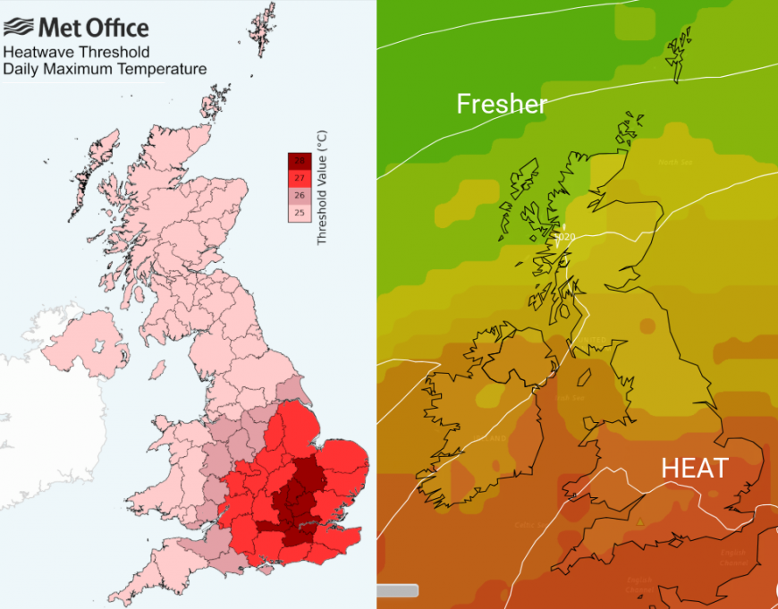
We still have this divide on Sunday as the frontal boundary wavers about. At some point, there will be a pulse of rain from the west but there is some uncertainty around the timing and path of this. Northern Ireland and western Scotland look most prone at the moment. Elsewhere, the heat and humidity will continue with plenty of sunshine. The winds will have eased and there will be more of the southern half of Britain reaching into the mid-20s, even high 20sC on Sunday. Some spots could reach 30 even 31C, it will depend on how much cloud reaches in along the frontal band.
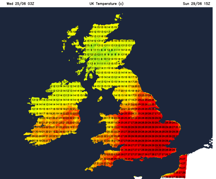
UKV model temperatures with 25 to 30 showing across much of southern Britain on Sunday.
That heat could spread further north on Sunday night but a low pressure south of Iceland will try to sweep fresher air in from the northwest. If the heat remains for Monday, everywhere will feel hotter and temperatures could rise into the low 30sC. Wimbledon starts on Monday, this heat and sunshine can't last?
Loading recent activity...