If the heat is becoming too much, when will it end? If you can't wait for a hot and sunny weekend, then how long will it last?
If the heat is getting too much for you, there will be a change through the weekend. If you are just waiting for the weekend to get out and enjoy the hot and sunny conditions, it is not over just yet. The heat will be gone for everyone by Sunday night, lasting longest for East Anglia and SE England.
For anyone taking exams at school, this should come as some (late) relief after a week of heat, high pollen and increasing air pollution.
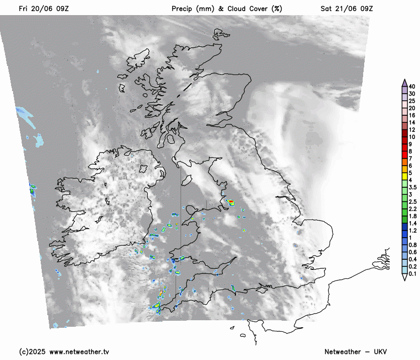
Friday’s picture was complicated by areas of high cloud just impeding the highest temperatures and small clusters of showers with more cloud. We have seen temperatures surge towards the high 20sC this week with 32.2C in London on Thursday, with brilliant sunshine. Even with some high cloud, Tyne & Wear managed to reach 30C on Friday afternoon. The top temperature on Friday was 30.9C at London Heathrow.
For the end of the working week, we have a combination of strong June sunshine heating already warm areas with a flow from Northern France, where there have also been days of clear skies and heating. Added to that, there has been a hot and humid flow from Spain, increasing the uncomfortable feel to this heat episode by day, and by night.
As you might expect, when we have a combination of heat and humid air, it all ends in thunderstorms. Or at least some heavy downpours.
Looking at the weekend, there will be a gradual change from this heat and high temperatures to fresher air from the Atlantic in a more westerly flow. Here is a look at those timings around the nations and regions.
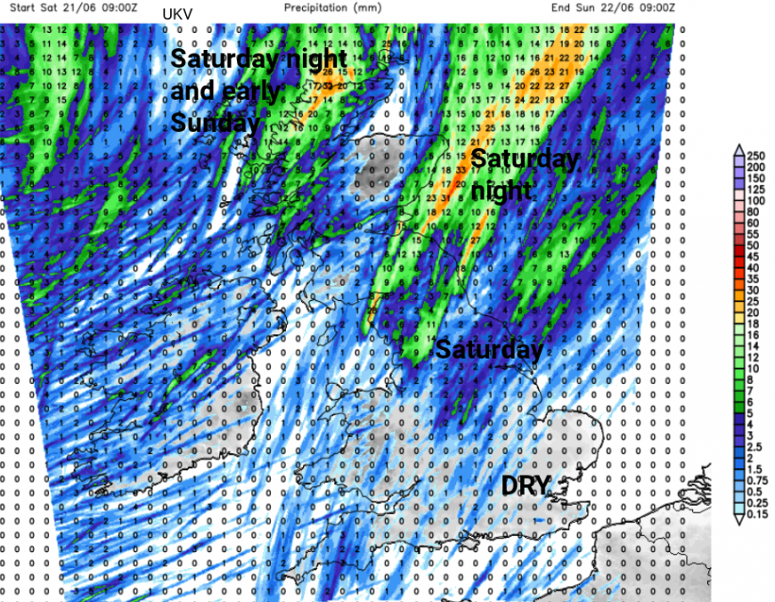
Friday evening will be very warm and sultry. There is the risk of a few heavy showers even thunderstorms for NW England around teatime which might reach across the Yorkshire Dales to Teeside this evening. Most areas will stay dry but it will be worth watching the radar for developments from the area of cloud over north Wales at 4pm.

England
After an uncomfortable night, Saturday will start off very warm and sunny for most. There will be some high cloud from the southwest associated with a scattering of showers. The heat will soon build across England. Again any cloud or heavy showers will complicate the high temperatures forecast but most areas will stay dry. Northern England should reach the high 20sC with the possibility of 30C for eastern England. Through the Midlands on Saturday, temperatures will be in the high 20sC and tipping into the low 30sC on another heatwave day. For much of southern England, the temperatures will be 25 to 32C but feeling more comfortable around the coasts. Inland Eastern and Southeast England are most likely to see 32+C with the possibility of 33 or 34C. Inland central northern England could also reach 32C as this will be the peak of the heat. There will be a southerly flow by day. Do take care in this ongoing heat as the nights will be uncomfortable.

The Met Office does have a Low likelihood/Medium Risk yellow thunderstorm warning across northern England.
“Scattered thunderstorms may cause some impacts Saturday afternoon, into the evening and night.”
There is more detail about the convective threat and wider risk of thunderstorms here
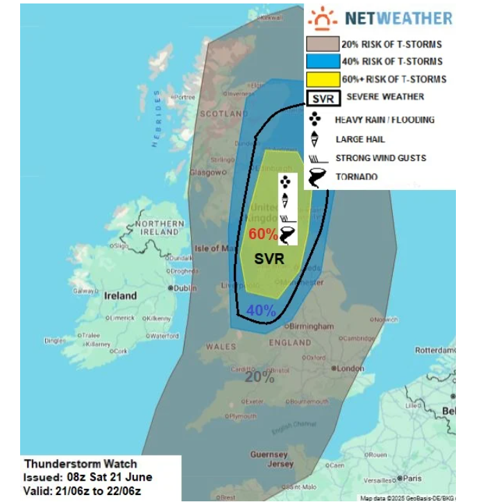
See Convective Forecast for more details
Pulses of elevated showers will drift northeastwards from lunchtime over northern England, but things could get very lively during Saturday evening over northern England (also into eastern Scotland) as the storms develop and drift northeastward.
“…further storms to develop later this afternoon and early evening across N Wales, N Midlands, N England - which will also eventually push NE across southern and eastern Scotland…storms to organise, perhaps into one or two supercells or bowing line segments capable of producing large hail and strong wind gusts. Intense rainfall leading to localised flooding and frequent lightning is also likely.”
Central and eastern England will remain muggy and very warm with an uncomfortable start to Saturday night. Further west, there will be some relief as temperatures begin to dip and a fresher breeze from the west arrives.
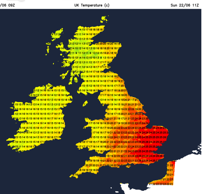
By Sunday, the temperatures for most of England will be in the low to mid 20sC and it won’t feel so oppressive. East Anglia, London and Southeast England, particularly Kent, will still be very warm, but not as hot after another muggy, close night. Temperatures in the east and southeast will be in the mid to high 20sC by day.
Many places will have a fine Sunday morning but with increasing cloud. Showers will appear for NW England and these will become heavier and more frequent through the afternoon. SE Britain should see a fine day with more comfortable warmth and sunny spells.
Scotland
One change will be for coastal northeast and eastern Scotland as the Haar will have drifted in on an easterly breeze. This will bring a fresher start, but it won’t last. In a gentle southerly flow, there will be heat again for Scotland on Saturday. Temperatures will range from 21C along the west coast to the high 20sC for inland eastern parts. To the lee of high ground and with clear sunshine, Scotland could pass 30C. The June record for Scotland is 32.2C which was from back in 1893. However, a veil of high cloud would inhibit the rise for northern Grampian.
During Saturday evening, the fresher SW flow begins to arrive but the heat will still be over eastern Scotland. There is the risk of heavy, thundery downpours moving over the Southern Uplands, perhaps impacting Edinburgh and brushing the east coast of Scotland on their journey northeastwards. These could bring intense rain and the risk of flash flooding.
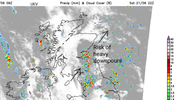
As one lot clears away from Aberdeenshire with residual heat, more heavy and thundery showers will arrive for western Scotland heading up to the NW Highlands.
Eastern Scotland will be warm on Sunday but not feeling as hot and there will be further scattered showers from the west. The day will feel fresher with the temperatures widely in the mid to high teens and low 20sC.
For Northern Ireland, we have seen temperatures in the high 20sC on Friday. On Saturday, the temperatures will be around 22 to 25C with a southerly breeze for Belfast and it will be a fine, warm and sunny day. By Sunday, the temperatures across Northern Ireland will be lower with outbreaks of rain and more cloud. In a SW/W breeze, the temperatures will be 16 to 20C but it will feel much fresher.
For Wales, there will be a southerly flow as the heat continues but a change to the fresher westerly. There is some leeway around this timing but Saturday will start off warm and become hot once more, up to 28 possibly 30C in the north. For the west coast, there will be a fresher breeze with temperatures around 19 to 21C depending on how the onshore breeze develops. There will be a scattering of showers with a bit more cloud inland. Most places will miss these. The heat will begin to retreat away inland, away from eastern Wales. The westerly wind will reach across Wales with clear skies and Saturday night will be much more comfortable. Temperatures on Sunday will be in the high teens so it will feel quite different.
Take care of your pets in the heat- Dogs and hot weather
What is the difference between the Amber heat-health alert and other warnings?
Loading recent activity...