A look at the rising temperatures for the end of the week as they head into the 30sC and how the heat lasts at the weekend.
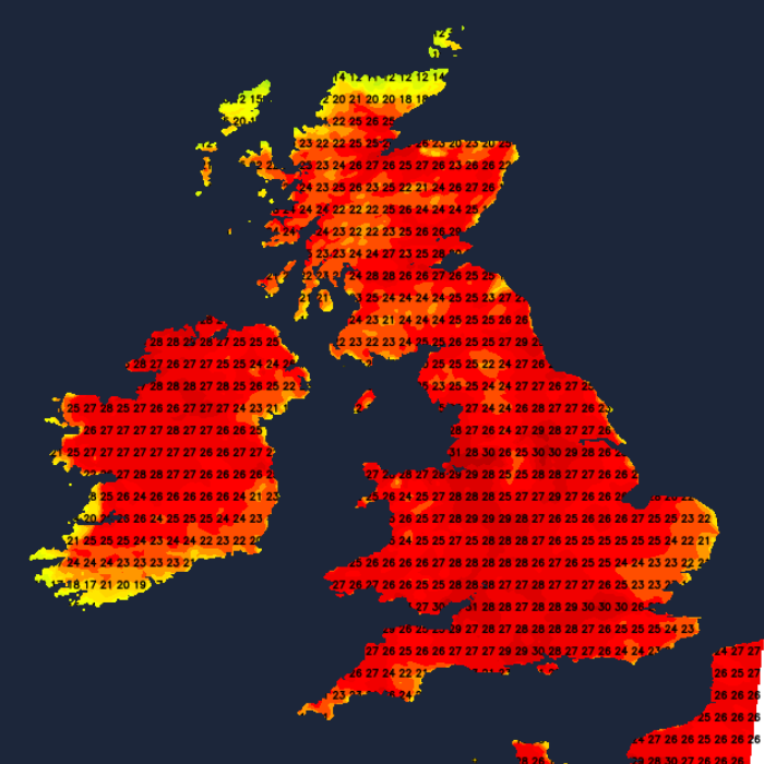
The heat will continue to build over the next few days. The top temperature on Wednesday was 29.3C at St James’s Park in London. Sheffield saw 25.6C, Cardiff 26.8C and Cambridge 29.2C on Wednesday, whereas Glasgow reached 18C and Edinburgh 19.2C. Thursday 19th has seen temperatures pass 32C.
Thursday will be very warm again for England and Wales, feeling warmer for Northern Ireland and SW Scotland too. There will be widespread heat on Friday, very warm nights and another hot day on Saturday as things begin to change from the west.
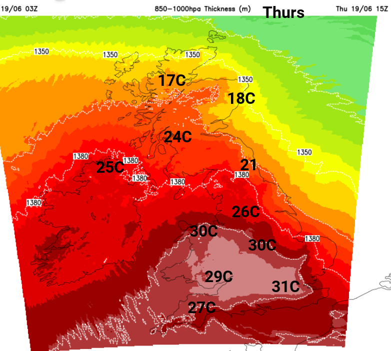
So far this week, there have been hours of unbroken sunshine for England and eastern Wales with slowly descending air under the high pressure. There is little disturbance to the air as it heats up day on day. In addition, at the end of the week, we have a gradual feed of hot and humid air from the south, which has been affecting Spain and Portugal. This combination of effects means that for Friday and Saturday 31C or 32C look likely, and even up to 34C is possible.
This extra heat and humidity will reach into southern Britain later on Friday and will surge up through Britain on Saturday. There will be very uncomfortable nights for sleeping, even resulting in “Tropical Nights” where the minimum temperatures don’t fall down below 20C.
Today there will be a lot of fine, dry and very warm weather. A weak warm front has brought more cloud to western Scotland and there are pockets of low cloud elsewhere. The cooler, fresher air in the far north is losing it’s grip and there will be less of a breeze today as the high pressure establishes itself.
Friday looks fine, dry and sunny. That glaring sunshine will only add to the existing warmth, leading to a hot day with very high pollen and widespread moderate air pollution.
“Warm and sunny conditions will continue, leading to worsening air quality on Friday. Moderate air pollution is expected to become more widespread, affecting much of the UK. “ DEFRA
A few complications for Friday include some high cloud but this fades through the day. Also, a light breeze from the south or southeast. This will keep the coast of East Anglia from feeling too uncomfortable. There will be more cloud for parts of Northern Ireland and western Scotland, with the chance of a few isolated downpours for NW Scotland by Friday evening and for Orkney on Friday night.
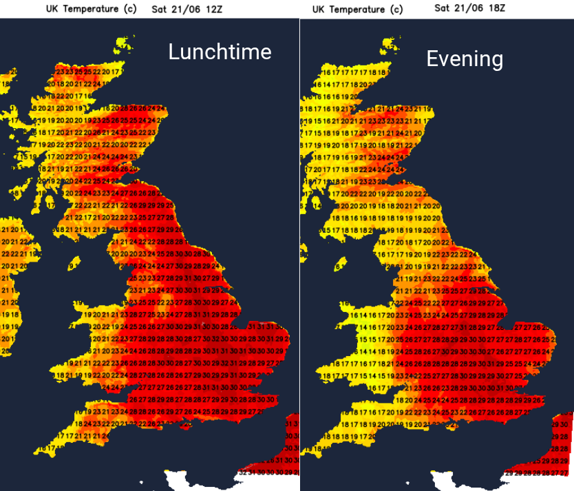
There will be a slight shift for Ireland on Saturday with more cloud and air beginning to come from the Atlantic. Temperatures in Northern Ireland will be in the low 20sC. There will be a mix for Britain with hot and humid air bringing the risk of a few downpours, scattered over the West Country, through Wales and a few reaching SE Scotland by the afternoon. These will be rather hit and miss but will bring more cloud. For many, it will be another hot, fine day with temperatures again in the mid to high 20s and low 30s C.
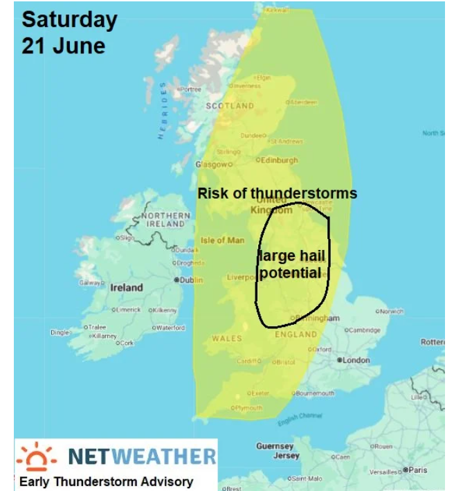
“There may be a risk of large hail - especially across parts of the N Midlands, NE Wales and N England, frequent lightning, strong wind gusts and intense rainfall leading to flash-flooding from these storms.” Convective forecast for Saturday
This added humidity may make Saturday feel more uncomfortable for some people. The sunny, hot weather over England for today is one thing but adding humidity can be hard to deal with. There is some uncertainty about where will be affected by the scattering of heavy, even thundery showers for Saturday evening and overnight, with another cluster heading for Northern Ireland.
There does seem to be a change to a breezy westerly, clusters of heavy showers mostly for the north and west of the UK. There will still be plenty of sunshine but enough disruption to the reserve of hot air that it could be just SE Britain seeing a very warm day with temperatures in the mid 20sC instead after another muggy night.
Loading recent activity...