We're into a lull now that Doris has left the scene, but wind and rain will be back later and into tomorrow, followed by another spell moving through on Sunday.
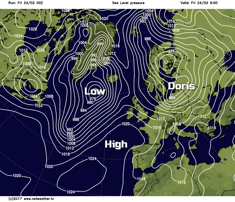
'Doris' has left us now with lighter winds today but in its wake, colder air as resulted in a slight frost mainly across northern Britain, with warnings of icy surfaces at first this morning mostly over Scotland, Northern Ireland and northern England. Further South it's not so cold, but it'll feel raw in the wind ahead of a transient ridge that'll cross all parts today.
Most places are waking to a dry, bright start with some sunshine, but we still have scattered showers. These are mainly towards the East coast and over North and East Scotland where some are wintry falling as sleet, hail and snow, the latter mostly on hills. There are also a few showers coming through the 'Cheshire Gap' into the West Midlands, but they'll fade through the morning as pressure continues to rise.
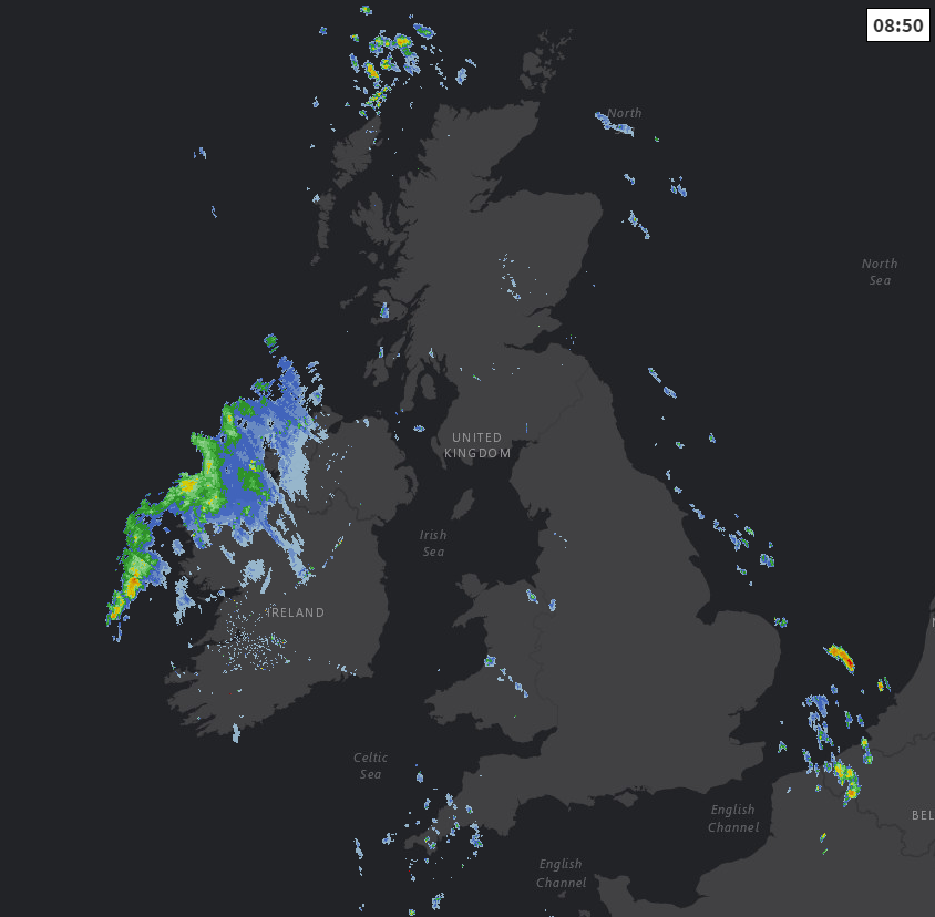
View the latest radar images here.
A transient ridge then gives most parts a dry afternoon with sunny spells, the exceptions being Northern Ireland and West Scotland where cloud from approaching Atlantic systems will bring rain before dark.
A North West wind at first will become a mostly moderate South Westerly by the afternoon, before freshening again over Northern Ireland and in the far West. It'll feel cold in the wind with the thermometer probably getting no higher than 4 to 6C over Scotland and parts of Northern England. Further South, top temperatures of 8 to 10C will be somewhat on the mild side for late February, but it won't feel so in the wind.
Clear intervals into the evening could lead to a touch of ground frost in some eastern areas before cloud invades from the West. This'll bring rain heaviest over Scotland, Northern Ireland and in the West, preceded by snow on Scottish hills. Here it'll turn misty with hill and coastal fog patches but elsewhere, the rain should be lighter and patchy with parts of eastern England and the South East likely to stay dry until morning. A South to South West wind will freshen becoming strong in the North and West, where gales are expected again. The wind however will be introducing milder air once more, with lowest temperatures about 2 to 5C in the East and 6 to 9C in the West.
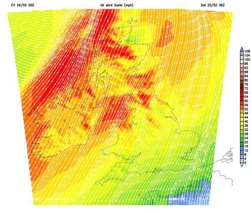
Saturday will be breezy and mostly cloudy, although you may see some brightness in the South and towards the South East, with somewhat clearer weather moving into Northern Ireland and the North and West of Scotland into the afternoon. There'll be occasional rain or drizzle with heavier bursts in the North and West at first, but in the East and the South in particular any rain should be light and patchy giving dry spells. It'll be misty in rain, with patchy hill and coastal fog in the West and South West. A South to South West wind will be fresh locally strong with gales in the North and West for a time, before winds decrease once the brighter weather arrives. It'll be very mild, with top temperatures 8 to 11C.
After dark, there'll continue to be showers over England and Wales, but the wind should decrease a little with skies tending to become more broken from the North West. Northern Ireland and West Scotland may also see showery bursts of rain returning later in the night, but remaining areas should become mostly dry. With lighter breezes and clear spells, a slight frost is possible in some sheltered glens of East Scotland by dawn, but across much of England and Wales temperatures shouldn't fall below 5 to 8C.
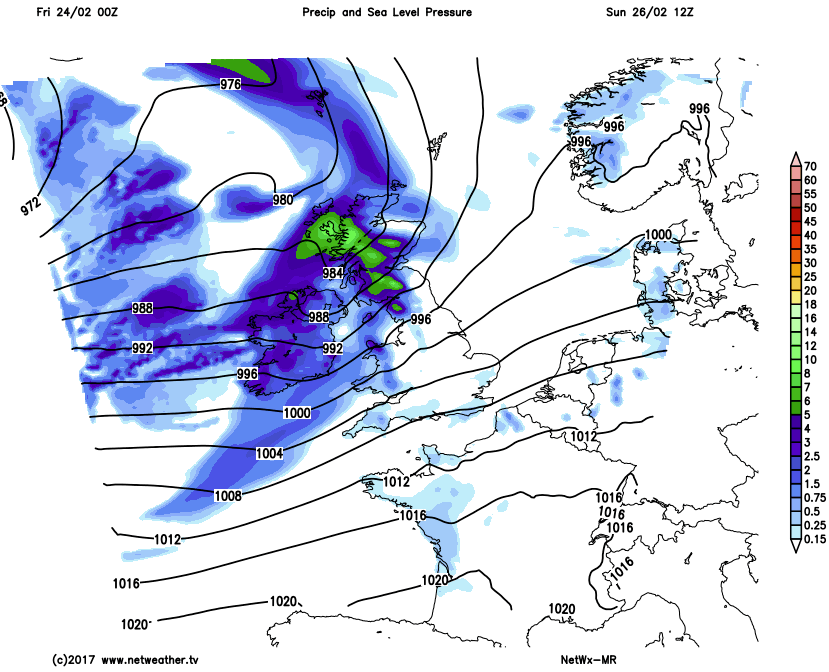
Sunday turns windy again with more rain or showers moving in. What's left of February then continues to have an unsettled look about it, and it'll also turn colder by month end, bringing the return of night frost and some snow mostly over hills in the North, but the cold spell isn't expected to last.