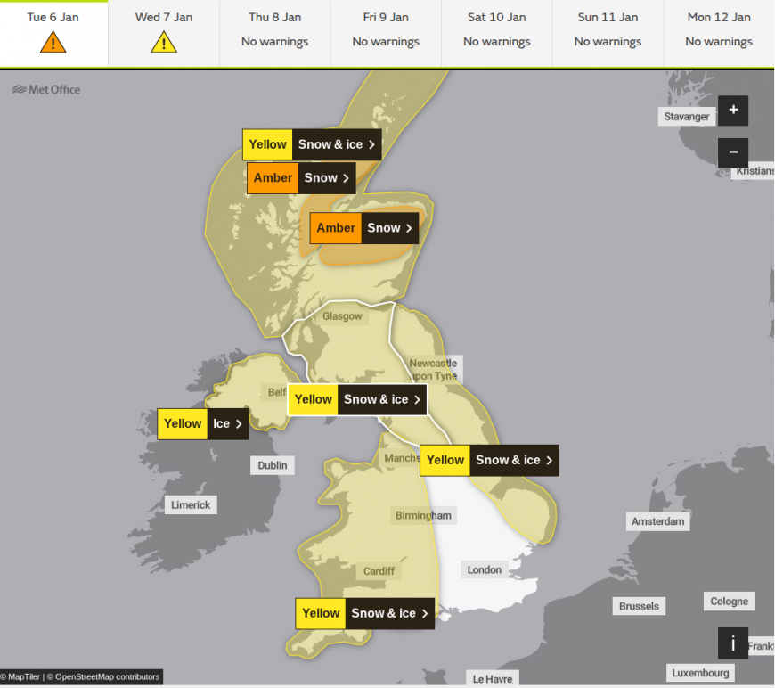
We still have Met Office amber and yellow snow and ice warnings for all but eastern England into Tuesday. The amber warning covers central and northern Scotland until 7pm this evening, where a further 5 to 10cm of snow is expected widely, with up to 15cm possible in places, particularly above 200 metres. Multiple yellow warnings for snow and ice remain in force across Scotland, Wales, western England and parts of the north, with an updated yellow ice warning now expanded eastwards to cover a more widespread risk overnight into Wednesday morning. But a slow thaw will arrive as it becomes somewhat less cold, with a mix of rain, sleet and snow.
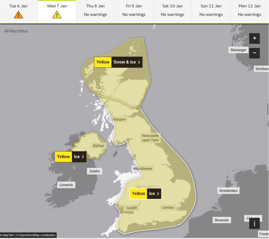
Wednesday is a little more straightforward with scattered showers, but it will remain on the cold side, especially in the north. A further yellow warning for snow and ice has been issued for northern Scotland on Wednesday, where a further 5 to 10cm could fall above 100 metres, with up to 20cm possible over higher ground above 200 metres.
After a few patches of freezing fog and yet another sharp frost, chiefly over England and Wales, Tuesday afternoon brings a change from the west. Initial snow has already turned to patchy rain over Northern Ireland, but the north and north-east of Scotland will see another 10 to 15cm of snow on hills before it becomes less cold, mainly in the south, albeit temporarily. As a result, snow at lower levels is turning to sleet or rain, bringing a slow thaw. But the cold is set to return from the north, bringing more snow by dusk to northern Scotland and to hills further south.
Across England and Wales, there will be more cloud than of late. This will give patchy, mostly light sleet or snow, with snow also ahead of an advancing front. This will eventually bring less cold air from the west, but nevertheless it will still be on the cold side, with a few places where you have lying snow, and in the east, struggling to get much above freezing point again.
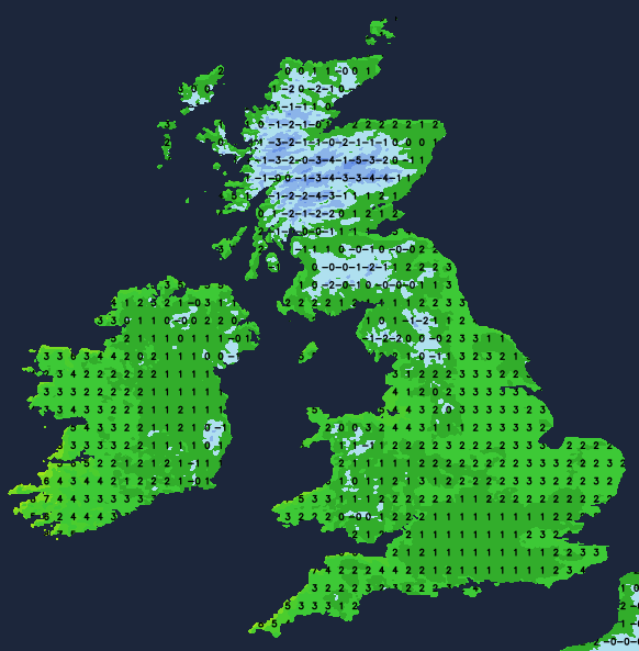
Although less cold than on previous nights, particularly across the southern half of England and Wales, it will still feel quite raw. Scotland will see the coldest weather with a frost and a raw north or north-westerly wind bringing wintry showers, particularly to the north and east. Here they will fall as snow even at lower levels, while elsewhere and across Northern Ireland any snow should be mainly on the hills. A yellow ice warning will come into force for Northern Ireland from 6pm. Lowest temperatures will be around -4 to +2C, with icy patches forming on any untreated surfaces, so take care. A widespread yellow ice warning will then cover much of England, Wales and Scotland overnight into Wednesday morning.
Across England and Wales there will be further showery outbreaks, giving hill snow, but with more broken skies at times as well, giving drier intervals. Later in the night, colder air may return to northern England where showers could turn wintry again even at lower levels. And with temperatures by dawn in the range -2 to +4C, here too there will be a risk of ice on any untreated roads and pavements by morning.
Showery rain in the south will soon move away, leaving most parts with a mixture of sunny intervals and just a few showers. Although less cold, it will not feel so in a north-westerly wind, with many of the showers still wintry, especially in the north and east of Scotland, giving further accumulations here and on hills further south. At lower levels though, expect mostly rain or sleet in any showers.
Northern Ireland and the South West may see fewer showers, but here another front may bring some rain later, with snow probable over the Mourne Mountains and the hills of Derry. Top temperatures for most will be 2 to 7C, with a slow thaw of lying snow at lower levels.
Wintry showers will continue to affect the north and north-east of Scotland, giving further accumulations of snow, mostly on higher ground. Our front across Northern Ireland and the South West will also make a little further progress, perhaps bringing a little rain and hill snow as far north and east as North West England, the Midlands and central southern England by morning.
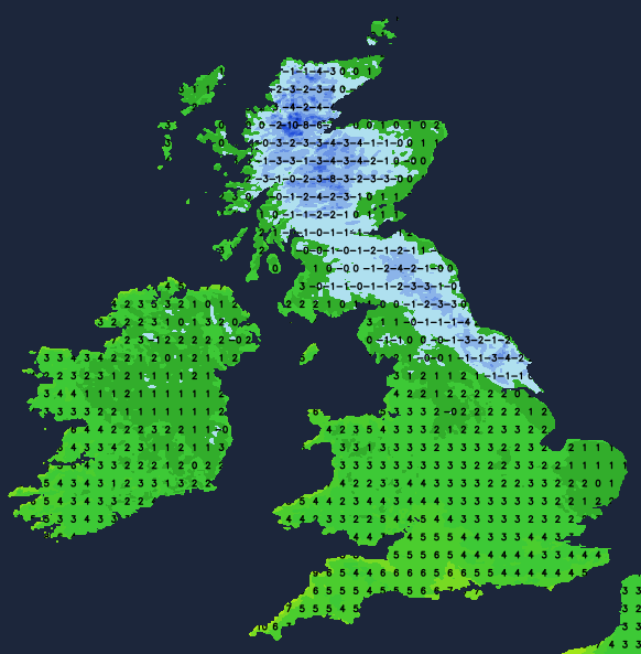
Elsewhere, the emphasis should be on dry weather with broken skies in mostly light winds. Where skies break there will be a frost, especially the further north you are, with lowest temperatures generally in the range -4 to +5C.
Thursday will see our front give a little rain, sleet or snow in places, finally clearing into the North Sea. Somewhat of a lull will then give broken skies before developments to the South West see a deepening depression move in. Its track, probably across the south, will eventually bring rain heavy in places with hill snow. Gales and snow to lower levels could also develop with severe conditions possible on Friday. So keep tuned to Netweather for the latest updates.
Loading recent activity...