Plume of very warm and humid air from Spain arrives tonight and will become increasingly unstable as cooler air moves in aloft from the Atlantic, bringing an increasing risk of thunderstorms in places.
Increasing warmth and humidity over the next few days, as a Spanish plume arrives tonight and spreads north tomorrow, will also be accompanied by a growing risk of thunderstorms in places, as the plume destabilises as cooler air tries to push in from the Atlantic aloft above warm and humid air spreading north nearer the surface.
Not everywhere will see storms, with some places just catching some showery rain pushing north, while it will become very warm and sticky as sunshine returns Thursday afternoon after a risk of thundery rain passing through in the morning. Much of Friday will see decent sunny spells too and feeling very warm and humid too, with temperatures reaching the low to mid-20s Celsius widely away from the far west, perhaps 28-29C across eastern England.
Plume of very warm and humid air will spread north tonight, which will become increasingly unstable Thursday and Friday

However, the heat and humidity will trigger localised heavy showers and some thunderstorms across parts of the Midlands, Wales and northern England in the afternoon, while more organised heavy downpours and thunderstorms look to spread north again across parts of England and Wales during the evening, as another cold front moves northeast, perhaps a risk of severe thunderstorms for a time across SE England - where a a very unstable plume of higher moisture and warmth spreading in from the near continent destabilises ahead of the cold front moving in overnight.
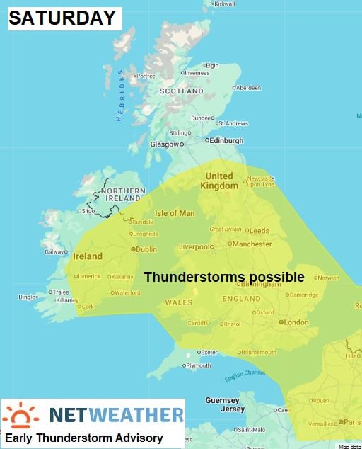
Saturday sees an area of low pressure to the south of Ireland swing northeast across the UK, this combined with surface heating of residual warmth and humidity will likely trigger heavy showers and some thunderstorms in places. But many places may miss them and stay dry and sunny
More detail on the thunderstorm risk over the next few days below:
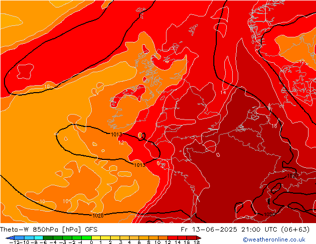
A plume of warm and humid air over France this afternoon, originating from Iberia, characterised by wet-bulb potential temperatures (theta-w) of 16-18C, will spread north across SW England and Wales tonight, as flow backs southerly ahead of amplifying upper trough to the west of Europe. On the western edge of the plume, marked by a waving cold front lying north-south, a band of heavy rain and thunderstorms is moving northeast out of Spain across the Bay of Biscay and approaching Brittany early evening..
This band of heavy showery rain and storms along the surface cold front moving NE will continue to move north SW England, south Wales, and southern Ireland tonight, before continuing to spread north across England, Wales and Ireland on Thursday, showery rain and any storms tending to weaken as it reaches northern and eastern England, as upper forcing weakens. However, further scattered surface-based storms may develop across parts of the Midlands, N Wales and NW England in the afternoon - as breeze convergence develops in still warm and moist airmass - which will become unstable to surface heating..
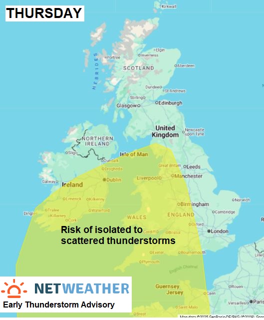
The upper trough located to the west over the nearby Atlantic is expected to develop into a cutoff upper low - which will drop close to the south of Ireland. Thunderstorms may develop during the day due to surface heating into the mid to high 20s of the moist airmass combined with breeze convergence - more particularly across the Midlands and up into N England along with Ireland.
Very unstable plume of very warm and humid air clips SE England Friday evening
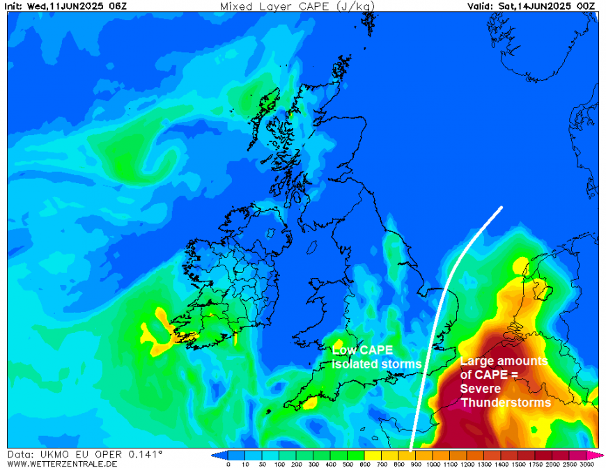
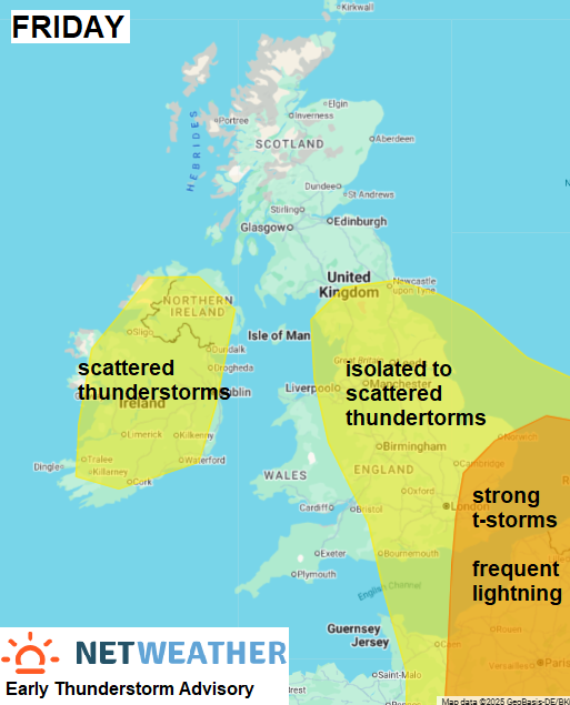
After a relaxation east of the plume on Thursday afternoon, a reload of high (16-18C) theta-w plume looks to occur towards SE UK into the evening - with significant instability / large CAPE on the near continent spreading in across SE England and East Anglia. Upper low moving to the south of Ireland will lead to a tightening of the mid-level SW flow gradient and associated height falls over southern UK creating increasing large scale ascent, which combined with lift from shortwave troughs moving NE in the increasingly cyclonic SW flow, will support the development of strong thunderstorms moving NE across SE England, East Anglia, East English Channel and near continent in the evening/early night. The storms may form a Mesoscale Convective System clipping far SE England and over near continent, with risk of frequent lightning, hail, 30-40mm rain in an hour and gusty winds. Heavy downspouts and some isolated thunderstorms spreading north across England and Wales further north and west too during the evening.
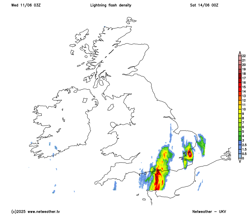
More uncertainty by Saturday, but it looks like the upper low to the south of Ireland will then move northeast, with a shallow surface low, across the UK during the day. Colder mid-levels associated with upper low will steepen lapse rates with surface heating, while convergence and cyclonic vorticity associated with the low moving northeast will combine to support development of heavy showers and scattered thunderstorms across parts of the UK, with a risk of hail, gusty winds and flash-flooding.
Loading recent activity...