Updated 23rd December - Covering 29th Dec 2025 - 20th Jan 2026
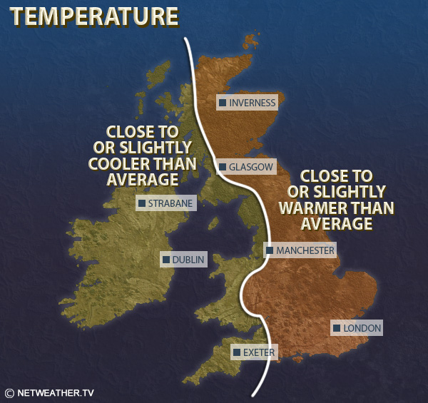
Mean temperatures are forecast to be generally below normal, probably by 1 to 2C in western and southern parts of Britain, but close to normal in many eastern counties, especially near the coasts of eastern Scotland and north-east England.
It is expected to be drier than normal in all parts of the country, especially in the west of Britain, but with nearer average precipitation possible near North Sea coasts. Potential for wetter weather around mid-January is unlikely to offset dry weather up until that point.
Sunshine totals are expected to be above normal for most, but they may end up close to normal in some eastern counties, especially near North Sea coasts.
This week will be dominated by high pressure, centred over north-western Britain, bringing predominantly dry weather. During the early to middle part of the week, easterly and north-easterly winds will often being plenty of cloud off the North Sea into eastern parts of Britain, while sheltered western parts of the country will see more sunshine. Temperatures will tend to be close to the long-term seasonal average near North Sea coasts, with the winds coming in off the comparatively warm North Sea, but it will often be colder than average in the west and south of Britain in particular, especially by night, where overnight frosts and patchy fog are likely to recur. Late in the week we may see the winds start to turn more northerly with high pressure moving further away to the west, bringing potential for showers, possibly wintry especially in the north-east and on high ground, into eastern coastal areas and more sunshine generally, with overnight frosts.
Mean temperatures are forecast to be near or below the 1991-2020 long-term average, generally within a degree of the average along North Sea coasts of eastern Scotland and north-east England, but probably around 2C below average in most parts of western Britain and southern England.
It will be considerably drier than normal in all parts of the country, some places, particularly in the west, may stay completely dry.
Sunshine totals are forecast to be generally above normal in western Britain, especially western Scotland, but they may end up near or rather below normal in some eastern parts of Britain, especially in counties bordering the North Sea.
This week is when we are most likely to see significant wintry weather, as there is a likelihood of north-western Europe seeing some northerlies originating from a long way north. However, it is not currently clear whether these northerlies will make a direct hit on the British Isles or end up predominantly shunted away east into the North Sea and central Europe, as there is potential for high pressure to stay very close to the west of Britain. Thus, it is uncertain at this stage whether there will be widespread snow, but there is a possibility if the northerlies hit the British Isles full-on. Either way, it is forecast to be on the cold side, and probably drier than normal over much of the country, particularly in western counties. There is a possibility of the winds turning more westerly towards the end of the week bringing in milder air, but confidence in the timing of this is currently low, it may not happen until substantially later in January. Temperatures are expected to be generally 1-2C below average, with most areas drier and sunnier than average although North Sea coastal areas have potential to end up with near average precipitation.
During this period we are likely to see a transition towards milder and more changeable westerlies. It is possible that this change could be delayed until nearer the end of January, but it looks most likely to happen around the 10th-15th. It is most likely to still be colder than average early in the period, perhaps turning milder than average towards the end of the period. Thus, mean temperatures during this period are most likely to be near or slightly above the long-term normal. It will probably be sunnier and drier than average for most overall, due to polar air dominating early in the period, but with a trend towards wetter conditions towards the end of the period.
Monthly weather forecast
The month ahead forecast is written by Ian Simpson and is updated every Monday.