Issued 2025-07-30 17:58:48
Valid: 30/07/2025 1800 to 01/08/2025 0600
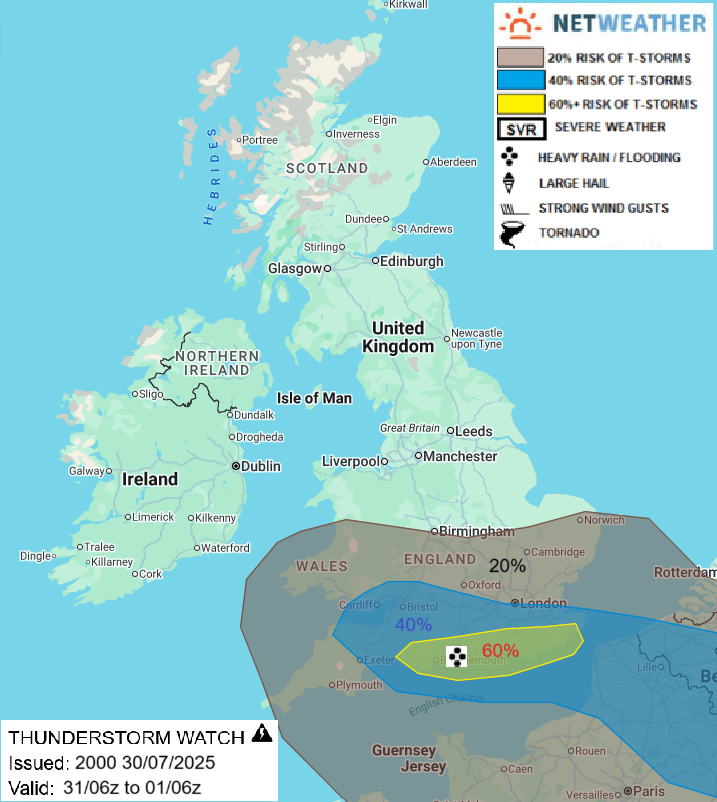
The UK will be under a cyclonic northwesterly flow on Thursday, unstable across southern UK. A shortwave trough to the west of Ireland Weds evening, visible on WV satellite imagery, will move ESE across southern Britain during Thursday, steepening lapse rates and creating large scale lift of fairly warm/moist tropical maritime airmass (theta-w of 14-16C at 850 hPa) spreading east across southern UK. Heavy showers and thunderstorms are likely to develop and move ESE across southern England during the day as result, enhanced by surface heating in sunny spells following a spell of showery dynamic rainfall along frontal wave moving east in the morning. Although vertical shear will be weak, thunderstorms will train and organise along breeze convergence that is forecast to develop towards south coast between westerly and northwesterly flow, this may lead to localised flooding - especially given precipitable water (PWAT) of 30-35mm forecast. Isolated localised flooding also possible elsewhere in t-storm risk areas delineated, along with CG lightning, hail and gusty winds. A few funnel clouds or even a brief tornado/waterspout are possible towards south coast along breeze convergence.
Issued by: Nick Finnis
Issued by the Netweather forecast team whenever there is a risk of storms or severe convective weather, these discussion based and in depth forecasts will highlight the areas at risk and give an in depth description of the risk and the factors surrounding it.
Loading recent activity...