


Simonl
-
Posts
62 -
Joined
-
Last visited
Content Type
Forums
Blogs
Gallery
Events
Learn About Weather and Meteorology
Community guides
Posts posted by Simonl
-
-
Morning!
A light snow shower here in Herne Bay - Which makes a change! Given wintry showers for this area - wait and see! Have a good day all

-
Not been on here for the last week or so, in terms of stats and forecasts, is there any hint towards a warm up at all? As a prospective beekeeper, I need some warmth to get my bees homed!
I bought a beehive for Christmas! I am waiting like you to get my colony! I think we are going to have to wait some time yet my friend. Would hazard a guess and say cold at least until 8th April the rest is FI !
-
Coast
Latest GFS shows rain and plenty of it for us just for the southern strip of the UK - Typical. It appears the ppn shows up ahead of the cold uppers we need. Frustratingly everywhere seems to do well out of it again. What's your take on this? Do the other models show anything different? Just seen your thought in the model thread. A few others thinking the snow boundary is moving south or trending further south?
Your thoughts would be appreciated!
-
Morning all, I was confused by the forecasts this morning, my met office app says 10c and rain for Friday but as Coast said when he kept us abreast of the situation this morning not sure where that makes snow!
Even on the written bit of the met office they mention snow but their pictures show rain!
Confused.com
Have good day and keep fingers crossed for snow if that's your thing, otherwise its gonna rain!
This winter has been somewhat crazy really. that last low that went through the channel I really thought would deliver to all of our region, we didn't see a single flake to speak of and as we know it dived through the channel islands....Now we have another bite of the cherry and the north/north east will see snow...we get the rain....I HATE cold rain. I would say that if we miss the snow, let us have some nice spring like temperatures at least. Greedy North lol
Sorry to whinge.....I'll just collect the toys that I have cast out of my pram lol!!!
-
A warm front?
lol a warm smile certainly
-
Next week looking positive.
T84
T90
T96
SNOW DEPTH.
Hi!
What site is this on please? ta Simon
-
Medways snow shield finally falls. Meto only showing snow up to mid morning now but would not be surprised if we see more.
yeah, glad the shield has gone..sorry mate but to be fair you got loads and we have had none. Send us some please. ta. lol btw, I came from Medway to live here. I wanna move back now with all that snow lol
-
Morning!
It seems some of our region are the favoured few...yet again sadly others miss out. My region has been EXTREMELY poor with the odd flake of dandruff but most annoyingly the cold wind has been just that..RAW. Shame. I cannot work it out really why we missed out since we SHOULD be in the firing line for snow. You go to medway and they are covered in it. Quite amazing really. Anyone got any takes on this? Will we see any today?
-
Some serious issues here
Run out of chocolate
Run out of alcohol
Cannot find tape measure to get snow depth
Call it ten inches
Nasty
-
Well after a winter of near misses, we've been getting a right pounding today in Appledore, and there's no signs of it letting up - if anything the best is yet to come. Some insane drifts where the gaps in the hedge lines has allowed the wind to pick up & dump it's bounty on the country lanes. Goes from an inch or two to a foot or so in the gaps and some great winddrift shapes forming.
Lucky
-
Cracking day for some in this thread and more to come. Absolutely bugger all here. Only just been re-connected Virgin have fixed the box,Now where's me bloody snow.
Language..Timothy
-
Fourm is alive!!! Typical.. My net weather extra runs out in 2 days... ARG!!!!
Subscribe again! I am gonna mate lol
-
Ian F just posted this in the mad thread.
http://forum.netweat...tainty for now.
UKMO now happy with GM out into Sun/Mon with v good consensus between it and EC EPS re handling of frontal zone slipping south into Sunday, with accompanying earlier onset of colder conditions. So, 00z GM accepted with very little modification. Strong signal for transition to sleet/snow on rear edge of front during Sunday, but with forcing being rapidly lost the PPN amounts/rates will be diminishing, so shouldn't be too bothersome. On Sunday, most snow accumulations of any note (i.e. 2+cm) signalled away from windward coasts over high ground, albeit any shower alignment parallel to the flow by Monday could give some patchy issues in E'rn areas. On the coastal fringes, however, the keen flow off N Sea will help inject sensible heat and diminish snow threat here.
Generally, low-level snow accumulations considered to be largely very temporary through Sun-Mon, due to recent rises in depth temperature. Both EC and UK4 show very muted amounts (1cm or less) in patchy distribution for southern UK by later Sunday; highest accumulations on higher ground such as Pennines, parts of Wales and Exmoor.
For Monday, good agreement on drier regime excepting few snow showers around in E/NE, with potential for banding (and thus localised accumulations) the key uncertainty for now.
Stav Danaos made me laugh on the BBC national forecast just now where he virtually whispers the words "...will see some snow" take a look it made me chuckle....! Think we could be in luck sunday/monday
-
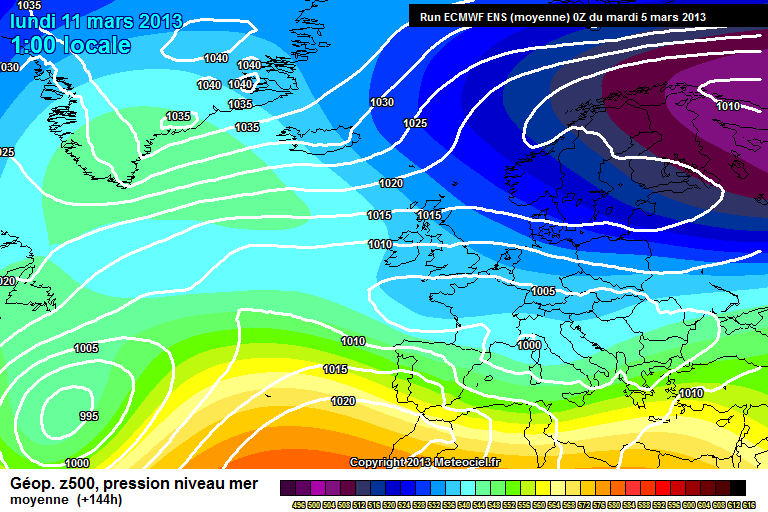
Absolutely incredible ensembles below. Rarely will you see the mean at -12C but to see this being projected in mid march is even more outstanding. Im even more delighted to see the cold arrive on the 10th March!
http://cdn.nwstatic....bridgeshire.png
I feel Gibby has massively underestimated the GFS in his summary by saying "chilly with wintry showers". If the GFS is right then on Sunday we would see widespread snow showers with temps struggling to get above freezing with dewpoints as low as -10C.
Looking at the ECM mean and I feel the ECM/UKMO will back towards the GFS rather than the other way round.
I can see on the models that even us in the SE corner MIGHT see some snow if the synoptics ring true.....Winter's last sting? Cambridgeshire and Norfolk always seem to fair well out of these set-ups, eventually if the pattern holds, the SE joins the party so to speak!
-
Radar really coming alive now, dare I say a Wash Streamer lol. Currently have moderate snow falling rather than those silly flurries and looking at the radar im expecting a covering over the next hour or so, maybe even a few cm. A very interesting evening ahead for me
From a forecasting perspective very pleased with how its gone today. I said last night the focus of showers would be NE England and then Lincs, E Anglia with the shower activity weakening in the SE.
Typical
-
Hi, its just my general five day forecast: ..., looking at the rainfall map on the meto website, it just showers though, rather than constant precipitation, so the forecast's a little misleading. Dont think it will come to much.
Tonight says heavy snow for the SE! lol! Wish it would make up its mind one way or another......The weather that is Cheers mate
-
Met Office have got snow forecast from 9PM this evening to 3PM tomorrow afternoon, with 6 hours of heavy snow overnight. Can anyone tell me what this is about, I don't see any met warnings, are accumulations expected at all?
Where is that posted? Can you provide me with link please? Thanks
-
Channel is now really coming alive hope it can push inland
Hi Tom
It should on that brisk north easterly wind for goodness sake! ??? lol
-
Morning folks!
Sorry to say not even a light dusting and I am on the extreme se coast. Where is that low pressure going? Surely, we must be in the firing line at some point? Ironically, met office have a warning out for NE England again! Makes you laugh. In the mod thread it was meant to be kent most 'at risk' ..................Or am I missing something? Any thoughts?
-
Late this afternoon an upgrade in terms of snow possibility. best days saturday into sunday I would say. Outlook remaining cold and possible northerly first week march!
THe radar gets better & better each return-
ETA north west kent- ~ 1130-
lots & lots of greens.......
S
Ooh Steve - pack it in lol
-
The GFS is an upgrade in terms of precipitation type and for us in the SE corner. In particularly for late this afternoon! Risk remains throughout until monday.
-
a bit better thanks just having my first warmish cup of tea a little pain but bearable, yes will keep updating but i wouldnt hold your breath on comming home to a white bay
I think later on maybe it will become more intense..who knows?!
-
very very very light snow here in the bay for last 20 mins
Very light...hope it peps up a bit.
-
I think we're all straw clutching,this winter has been a huge letdown for snow lovers in the region,unless we get a good dumping,I hope the warm sunshine we had a few days ago returns.don't get me wrong a light dusting is better than nowt,but when the south and south west have fared alot better its got to make you wonder whats needed to get the white stuff
Snowrye
Patience! I have just seen (THOUGHT I had imagined it, only been up about 10 minutes) A FLAKE! it was about the size of a five pence piece (honest!) Right, calm down, calm down!! lol (controls self)


South East & East Anglia Regional Discussion 4th April 2013 onwards
in Regional
Posted
Morning!
None as yet but it wouldn't take much of a shift northwards for us to catch something.....!