


Mark Bayley
-
Posts
3,164 -
Joined
-
Last visited
-
Days Won
2
Content Type
Forums
Blogs
Gallery
Events
Learn About Weather and Meteorology
Community guides
Posts posted by Mark Bayley
-
-
So where i think we stand tonight based on the models:
- Much colder from from Sunday until at least Thursday. A relaxation looks likely closer to the weekend, but its too far out to speculate what that might look like. See the brilliant posts from Tamara and others in the MOD thread
- Any low from the south is going to be too far south for us, and i'd bet for much of England by the end of the weekend.
- Several chances of snow from the north and north west. The GEM, UKMO and ECM all bring organised precipitation in from the NW between Tuesday and Thursday. These little systems will change multiple times between now and next week, so i wouldn't get hung up on individual runs. The point being that I'd be very surprised if at least some of us didn't have couple of CMs towards weeks end!
-
 5
5
-
 1
1
-
So the ECM and GFS 18z potentially push precipitation associated from the low in the Azores as far as the south of our region (probably Sheffield the northern limit for the ECM, the GFS a little further north), the GEM and UKMO take it much further south (but bring a band of snow down from the NW). As is stands my money is the later (though a band of snow being less certain!)
 .
.
Edit: 18z Ensembles track the low much further south, some not even reaching the south coast. Lets see what tomorrow brings. This won't be resolved for a few days yet..!
-
Indeed, and as flagged by @Harsh Climate in the MOD thread the UKMO has a similar feature to the GEM from the North West. The ICON had something on Tuesday and thereafter after looked dry, but given the deep level of cold / instability you'd expect surprises to crop up. In regards regional preferences, i think we want the UKMO / GEM solution. Yes we miss out on the battle ground snow, but as flagged above, plenty of opportunity for systems and disturbances.
-
3 minutes ago, Harsh Climate said:
I'd rather get the big dumping of snow first mate, then I would be content even if that was the last of the snow for me!
Problem is you can keep missing out while same places get hit time and time again.
Many options on the table. The GEM has the low flirting south of the M4, but then brings a system down from the north west delivering now quite widely. Would much prefer this option, and as noted by others, lows on the whole tend to trend south. Fascinating days ahead
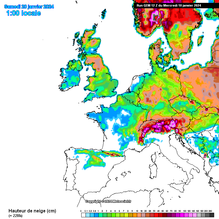
WWW.METEOCIEL.FR
Meteociel propose le modèle deterministe GEM-
6
-
2
-
 1
1
-
-
-
- Popular Post
- Popular Post
7 minutes ago, Met4Cast said:These lows tend to trend further south so I would expect models to occasionally barrel them through and bring in mild weather quickly but the reality will likely be a much slower transition. I.E more than 1 attempt to bring in milder weather with the potential for multiple snow events. Again though, where that boundary lies wont be known for a while.
It's possible northern areas will remain in cold air throughout (mentioned this in the above quoted tweet)
Indeed! Fully expecting that which is why I'm not entirely buying the modelling around the 17th at the moment bringing those lows in, suspect it'll be more delayed than that. (though, it doesn't ALWAYS trend south as you say, not something we can 100% rely on!)
Not often i comment in the model thread in recent years, but having been here for nearly 17 years experience has suggested more often than not these lows track south (and the GFS tends to over blow them / track too far north), and it is usually the second or third attempt that makes in inroads north. That's potentially the best scenario for the UK as a whole, with battle ground snow to the south, snow showers to north. Sadly someone will always miss out, but this scenario offers the greatest widespread snow potential. Will be intriguing to see how this evolves over the coming days!
-
14
-
Yep, probably the second low delivering better for us. Midlands gets a pasting. Some of the other runs less good, e.g. GFS and the GEM. I still reckon, if this is the route we go down, that lows will correct south. If so, hopefully that brings in snow showers.
-
@Harsh Climate yep. About 2 to 5cm across much of the region if it falls as snow. Looks like it could be marginal away from high ground for a short time. Would be good see the dew points. As you say the ECM is not the only model to toy with this. The previous GFS runs and GEM have had this too. One to watch!
https://www.meteociel.fr/modeles/ecmwf_hres.php?ech=6&mode=25&carte=6
-
2 hours ago, Harsh Climate said:
If I was south of the Midlands I would be very worried. We tend to do well from battleground scenarios, this could be the making of our winter!
I've seen strong cold NE/E pull with -12 uppers provide nothing but cold and dry for our region while Newcastle, Middlesbrough, Yorkshire Dales etc get battered by snow showers.. Time and time again.
I'd take battle ground snow any day now, forget those perfect NE with powder snow showers too rare!
Yes, GEM would have a snow to rain event, GFS likely just misses most of us (though snow might make it to Sheffield). Far to out to be concerned on detail, plus we might not get a low at all. If I was betting i'd think any low would correct south, thus leaving us out the battle ground (central Midlands being the sweet spot). thus leaving us to hope for disturbances / snow showers from the East. Lets see how it evolves.
-
1
-
-
3 hours ago, Craigers said:
Either way that GEM 12z is just a thing of beauty
18z also pretty good.,
Yes, i know we should take no notice of these sorts of charts, especially so far out. Those of us around long enough know the drill. Get the cold in, and whilst it might look dry, chances are disturbances etc... may crop up. 18z is perfect for that (and the GEM).
I also sense the models are toying with height rises towards the NE.. Tamara and others have highlighted this possibility!
-
1
-
-
1 hour ago, MattH said:
Hi.
I just wanted to create a post from an educational perspective and also be a point of reference regarding the importance of the GSDM and the AAM on the medium and long term. Hopefully, anyone who questions this should change their mind after reading the below. The reason it is worth doing this is because there is no better, clearer, example of the importance and connections between those upstream, Pacific developments and the downstream influence.
XXXX
Hi - really helpful post. I wondered if you or a MOD might copy this into the L&D section just so we can revisit please. Only had time to scan but don't want this to get lost into the thread. When i get a bit time would like to get my head around some of these drivers and this is a useful reference post! thanks
-
7
-
-
@Craigers - this is what we want..! Should be some juicy ECMWF charts by the weekend!
Meteociel - Cartes Ensemble GFS (ENS/GEFS)
WWW.METEOCIEL.FR
meteociel propose des rubriques météo temps réel, forums, modeles...-
1
-
-
19 hours ago, Craigers said:
Yorkshire would be in for a right pasting if that materialises
Yep - looking interesting as we move through Jan. Maybe even some snow showers next week if the initial high sits far enough north (e.g. latest GEM or GFS 6z) - though nothing special at this stage. The retrogression towards Greenland, should it happen, might be deliver something decent for our region. Either way, it will be drier, which is much needed!
-
Happy new year all - here's to something colder as we move through January. If I've learned anything of nearly 20 years of model watching it is to expect surprises! I'm a little dusty on SSWs, MJO etc.. these days but from what i do remember and have been following from others the 'background' drivers remain positive. Hopefully we get a bite of the cherry at some point, though a mid-latitude high seems favoured for now. Having just recorded 150mm of rain preceded by two months of 100mm plus I welcome some drier weather
Thanks to @Tamara @Catacol @Met4Cast @lorenzo @bluearmy and others for the incredibly informative posts over the past year. I really need to get back into some of the technical detail...!
-
4
-
1
-
-
7 hours ago, cheese said:
3 months above 100mm this year here, when we normally don't get any. The past few months is what living in Cumbria must feel li,e.
Yep, awful past few months (bar the snow!)
Year in summary
4 x month over 100mm and a yearly total of 956.4mm
- December - 150.2mm
- July -150.2mm
- October - 144.6mm
- November - 101.2m
Highest temp - 29.2c (June) - Weather station didn't record on the warmest September day (my fault for ignoring battery warning!), but presuming 30c not reached going by the nearest Meto station.
Lowest temp - 5.2c (December, though January got to -5.1).
Snow - March - 15cm and December 5cm (don't recall any snow in Jan or Feb - if there was it was a dusting!)
Happy new year all - fingers crossed for some wintry weather in January or February followed by a warm spring and summer..
-
2
-
148mm rain this month now -if I manage another 2mm later today it will be the wettest month of the year.
January looks to be turning colder, and thus drier. Having been on here for nearly 20 years I have learnt not to get hung up on the model dramas! A UK high followed by retrogression is a perfectly feasible outcome. I'd expect more runs like the GFS 6z outreaches as the strat warming begins to impact lower down. Always good to get snow in the darker months, though as March this year showed snow can stick around a few days even late on. A long way to go before then though!
-
3
-
1
-
-
Yeah same here. Pretty impressive and made the lights flicker. 35mm maximum rain rate. Wasn't expecting that! Still some distant flashes
-
3
-
-
A surprise thunderstorm here. Several flashes of lightning and thunder. Rain pretty torrential too
-
2
-
-
-
On 27/12/2023 at 10:55, Craigers said:
Annual report so far
Pretty wet then. Another miserable day, though okay between the showers. Fed up with this wind too!
-
1
-
-
10 hours ago, Craigers said:
30-70mm for tomorrow too!
24mm so far. High res suggested about 30mm which we'll probably reach with any later showers. Then, another 20mm before months end according to the GFS, so probably reaching 150mm in total. Had 144mm in October, 101mm in November. The wettest month was July at 150mm!
-
If anything lets hope January is a little drier.. Third month in a row with 100mm plus of rain (currently 98mm but that will go up tomorrow..). Ground is completely sodden
-
3 hours ago, summer blizzard said:
Never found them a problem, unlike the Pennines they are not really high enough to kill convection. Our biggest issue is that the ENE flows tends to push convection south so we get scattered showers while South Yorkshire gets streamers thanks to us being directly west of the Wash.
Thanks, given easterly seems a potential for later in the month it could make for an interesting Christmas period!
-
59 minutes ago, summer blizzard said:
This is more of a Channel Low that's a bit too far north, similar to March.
While we do get epic events from the east or north (6th Jan 10, 2nd Dec 10), a lot of time the frontal air is too dry and you get small flakes and blowy dust snow, the great snow from the east is shower based. Sliding Atlantic fronts (low west of Ireland, SE winds ahead of the front) deliver probably the best frontal snow as per 31st December 03, multiple Jan 13 events as these are the fat flake events.
Turned to rain here at some point after 1am. It's drizzle at the moment as the front has just about cleared.
Yeah, from recollection of when I lived near Worksop some of the best snow events came from the east or north east, though being a bit further south than here frontal events also did okay. Presume the North York moors can be a bit of a hinderence in North Easteriles for our neck of the woods?


Yorkshire and E England regional discussion - Dec 2023 onwards
in Yorkshire & E.England Weather Discussion
Posted · Edited by Mark Bayley
Noting has changed my mind on the overnight runs.
Widespread decent accumulations of snow never looked highly likely, but i am still fairly confident someone within the region will have seen a few CM's by weeks end from troughs / disturbances being picked up closer to the time. But also, a chance we might not, that's the reality unfortunately! Opportunities for something more widespread may come with an attempted pattern change, though perhaps not long lasting. A long way to go before then, and i'd be keeping an eye to the North East as we get closer to Feb..