


PB22
-
Posts
2,798 -
Joined
Content Type
Forums
Blogs
Gallery
Events
Learn About Weather and Meteorology
Community guides
Posts posted by PB22
-
-
Ooof, I'm glad I no longer live near the east coast, could be pretty cool and dull at times later next week IMO with that north-easterly flow:
http://www.wetterzentrale.de/pics/Rukm1441.html
Parts of Wales could be the best place to be next week.
Overall not a bad outlook and certainly a vast improvement on recent weeks, but that wouldn't be difficult. Must admit thought that I'm not totally excited by the outlook from a warmth and sunshine point of view...I think some may end up pretty disappointed but having said that most places should at least get a couple of decent days out of this next week, and some will see a week of good weather, but beware those close to the east coast and that cold, cold North Sea...
-
Was snowing hard last night when I returned home from Manchester at around 9:30pm, it was crazy to leave Manchester with the car thermometer showing 7C in the city centre, yet I got to Rossendale and it was -0.5C and snowing. There's normally a few degrees difference between the two locations, but last night was pretty crazy!
-
nice low res end to the gfs again , similar albeit later then the ecm for energy going north ,positive signs now that will hopefully be seen in the ens later

Signs similar to which have been in the far depths of FI now for weeks. I really wouldn't hold your breath.
-
And that's another week gone with cold conditions dominating:
Granted, the uppers aren't as cold as currently, but none the less with the wind it will feel pretty cold once more next week. To think at one stage it looked like turning milder by Easter, here we are still chasing anything milder way, way in the depths of FI.
-
I do feel sorry for those who live along the east coast this spring and early summer following this extended cold spell.. When, eventually, conditions do warm up, there will be a horrendous amount of sea mist/fog and low cloud plaguing eastern areas everytime the wind is from an easterly direction thanks to those North Sea temperatures being so subdued. Given synoptic patterns that could be a very frequent occurrence indeed, more so than normal.
-
Snowing moderately here and gradually increasing in intensity. Much "nicer" snow this with the bigger flakes and less wind.
-
On and on and on and on....
Today:
GFS T+192:
Anyone want to punt on a bid for the coldest Spring on record? I think this year has an excellent chance.
-
UKMO T+144 threatens another cold pool returning from the northeast:
-
Sunday afternoon hits the dizzy heights of 7c by 15:00 in the south and NE Scotland
Still well below where they should be for the time of year.
The worse of the cold possibly easing somewhat by the end of Easter, but overall it remains an extraordinary outlook for below normal temperatures.
UKMO T+96:
UKMO T+120:
If anything I spot a trend towards winds heading more into a northerly quarter next week.
-
One thing I think that is worth a mention is how consistent the model output has been over the last few days. Considering the difficulties posed by the current decaying system, the outlook for next week has been a jolly cold one now for a few days. Given that the models often struggle in unusual set-ups, I think they've been performing pretty well in the last couple of days.
The ECM is another bitter run for the end of March and it's looking pretty certain that this will continue into early April:
-
With a Day 10 mean chart like this from the 12z GFS I certainly won't be expecting to see anything milder yet:
Whilst the number of runs wanting to turn it milder before the end of March are gradually diminishing in number as the trend to a cold start to April gathers pace:
Manchester ensembles: http://modeles.meteo...un=12&runpara=0
-
Still snowing...this is getting boring now (not!). Some potential for somewhat heavier outbreaks in places this evening, an area of slightly more unstable conditions heading west/northwest across East Anglia, Lincolnshire and the north Midlands in the coming hours.
-
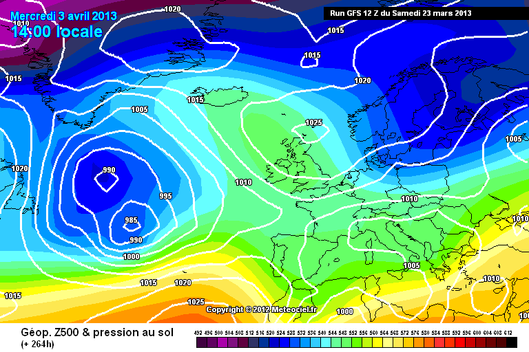
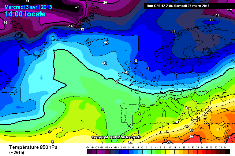
If you want milder conditions then I'd advise that you seriously look at booking a trip abroad. The cold is here to stay for many, many days yet, and well into April:
http://modeles.meteo...fs-0-264.png?12
http://modeles.meteo...fs-1-264.png?12
Even at the end of the first week of April the 12z GFS brings in very cold easterlies with a Scandinavian High:
-
Quite a night here with snow all night but the main feature was the wind blowing it about. So much wind in fact I honestly don't know how much snow fell because it's just all drifted. Another excellent event for my first winter in Rossendale, even if I did have to abandon my car and walk a mile home last night!
-
I remember how "shortwave" used to be the dreaded word for cold/snow fans...for us in this region it's been replaced by "shadow".
-
Jeez, some of you are up and down like a yo-yo. Chill people, its only the weather, this is the end of March and anything snow-wise has to be a bonus really, regardless of forecasts/model outputs. Don't get me wrong, I do understand why people are disappointed following the warnings, etc. but we do need to remember that:
a) A forecast is just that
b ) Warnings are covering the worst case scenario, which almost certainly won't happen for the majority.
Look at the Met Office's matrix for this event - look where the "tick" is. It's a high impact event, but low probability.
The main problem IMO is that people don't treat the warning's properly or how they are designed for. It's not necessarily the people's fault, I do think the warnings could be made a lot clearer, but that's another topic altogether.
Anyway, rant over, and its snowing here!
-
It looks like its going to miss us though- or am I reading the radar wrongly??
Why do you think it's going to miss you? It's on a direct collision course!
-
Things getting very interesting to our southwest now as the main precipitation band intensifies and begins its north/north-eastwards trip. Going to make for a very interesting afternoon and evening I feel and some areas are going to get cobblered before the next 24 hours are out IMO.
-
A slight cover here and currently snowing lightly but nothing too bad. Roads are clear and there is a slight thaw going on at the same time. All in all, messy!
-
We're well and truly in a rut at the moment with the cold spell continuing to gradually be extended day by day. Very unlike the traditional fare of cold synopics in FI never coming to fruition, instead its the milder synoptics which are not getting any closer whatsoever. Easter is looking increasingly cold and could be white for some, and I wouldn't be surprised if the cold continues well into April. Absolutely incredible output and I would place this spell of weather in the same category as December 2010.
-
Not quite as cold a run from GFS at t144 and t150 this afternoon
12z left 06z right
Wow, that's some serious straw clutching going on there Gavin! Desperate times for those of us wanting some spring warmth with the next week looking quite simply extraordinary. In all my years of weather watching, I've never seen anything progged for the end of March like we have for the coming days. Significant snowfalls, severe frosts and a notable wind chill helping to keep it feeling distinctly wintry.
-
Naturally, the 12z UKMO is rather different, and more in line with its 00z output:
T+120: http://www.meteociel...20-21.GIF?24-17
The far northeast may catch a slight northerly if the T+144 chart is to be believed:
Overall it looks like a pretty nondescript end to the week.
-
Proof, if it were needed, of the uncertainty for later in the week. At T+144 the 12z GFS has low pressure to the north and west of Iceland:
The 06Z GFS had pressure of circa 1025mb - 1030mb over Iceland!
-
Reality check.... This set up would give mostly rain on low ground from the midlands south with hill snow. Low ground in the north might do well away from the coast.
You couldn't be more wrong...if that chart verified there would be widespread snowfalls countrywide.


Model Output Discussion 12z 23/05/13
in Forecast Model Discussion
Posted · Edited by Paul B
Those temperatures are perfectly feasible, and this is why:
http://www.seafordweather.co.uk/wl/UKSeaTemp.htm
The North Sea still in single figures. As I said earlier, those hoping for warmth in the east next week will probably end up disappointed. West is the place to be, but even here those winds will subdue the temperatures. Plenty of fine weather around though, just a shame the temperatures will still be below normal for many.