


Generalelectrix
-
Posts
120 -
Joined
-
Last visited
Content Type
Forums
Blogs
Gallery
Events
Learn About Weather and Meteorology
Community guides
Posts posted by Generalelectrix
-
-
Hi @ all
Wow, amazing barrage of strikes in the channel and over the low Countries. This is so typical for the "Warm air intrusion" type of thunderstorms. Here we have warm moist subtropical air in a thin layer layer pushing over cold air of polar origin. Additional lift is supplied by pressure drop transporting it up into the colder upper layers of the troposphere. The wave nature of the warm air from the south combined with the cooler air at sea level coming from the north is a textbook example in this case. These type of thunderstorms can be of the most violent type and diurnal heating is not required here. Often overlooked in the charts..
Hopefully some action tonight in Sussex and Kent.
Regards
Ralph
-
 1
1
-
-
That's interesting, the bulk of the UK is still to the east of the cold front by 6am tomorrow on latest FAX.
I'm sure that previous FAX charts had the cold front moving through quicker.
Yes, that means another unstable day tomorrow, especially in the areas ahead of the front and directly on it, I cant really see cold air seeping in slowly in this case
Waitandsee
Ralph
-
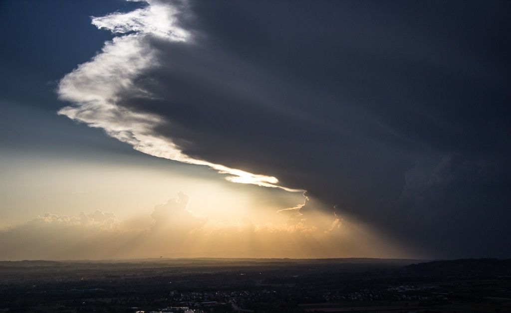
Spot the plume

In the angle of light from the sun setting in the west the plume becomes visible as the rounded hazy area ahead of the destabilizing atmosphere over the SW UK. Satellites are great toys methinks..
Regards
Ralph
-
6
-
-
I have the feeling this is going to root into the lower levels of the atmosphere as soon as it hits land, NMM has already hinted something like this 2 days ago. If yes fun time is guaranteed, maybe even more tha everyone reckoned with......
Enjoy
Ralph
-
-
1
-
-
Got some of those UFO clouds forming
those are Lenticularis or "Foehn" clouds, you happen to be near the base of some mountains?
regards
Ralph
Edit:.. and that means that nothing will happen (yet)
-
Some nice accas about now
.......image.jpgThanks Moki for posting a piccie of the real thing. Now some can finally see why they are called Altocumulus CASTELLANUS
Regards
Ralph
Erm Will, what you posting there? Cant see no AC on either piccie, sky looks more like soap suds in my washing machine
-
1
-
-
Hi@ all
Nmm 12z run has a new interesting ingredient for wednesday evening which was missing in the previous runs. Have a look at moisture at 700 hPa:
The previous runs (Someone posted CAPE and LI a couple of pages previously for Wed Evening) also had excellent CAPES, but with dry air up aloft the best CAPE is no good, at the most we would be staring at turkey towers and wondering what went wrong with the plume event for the umpteenth time.
This latest chart though is good, hope it stays that way, if yes I am slowly beginning to get excited too
Lets see what happens
Ralph
-
2
-
-
Quote Wolfgang Drill:
"Ohh well that was that then!......"
..wouldnt be too sure about that, I fully concur with gottolovethisweather, have a look at his post...
Cheers
Ralph
-
Hi@ all
Quote Mark:
"All looking rather calm at the moment.
Attached ThumbnailsThazza "loaded gun sky" , Its like the pot of milk a second before it boils over, mark my words....
Cheers
ralph
-
5
-
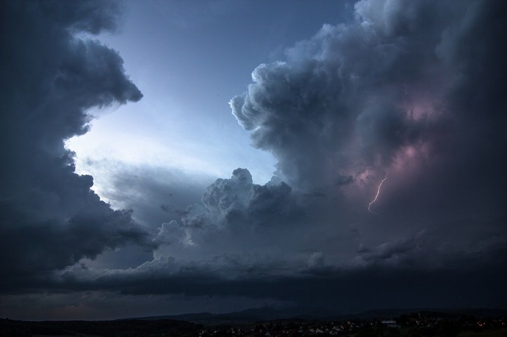
Evening all.
Got a huge constantly flashing storm system moving my way (am currently Lake Constance) from Zurich. Amazing rate of lightning and on radar zoom its beginning to show signature of a MCV
Courtesy Metradar
Here Link to Radar in realtime http://www.metradar.ch/2009/pc/index.php
Amgetting into car for a chase!
Cheers
Ralph
-
1
-
-
It would be a bit far fetched to presume that other ascents took place over the UK noontime today and that the data is being kept from the public, if though it should be the case then it would be quite sad because its the taxpayers money which is funding this and the info should be made public, even if it is just the raw data where we have to plot out our own skew-t diagram with pen and paper. I dont want to kick off a discussion now, was just a couple of thoughts from my side. Anyway, lets see if there is something for 00z
regards
ralph
-
1
-
-
@ davehsug : have scoured the net, and robt also came up with one sonding,for the whole of the UK noontime today and that was Cambourne. Or is it possible that other balloon soundings are not made available to the public? As far as I know not..
Ralph
-
@ Robt: Went to that site and indeed, seems that Cambourne was the only place which sent up a balloon today 12z, despite of todays necessity to monitor things more closely with the plume approaching. Quite sad that a civilized and densely populated country like the UK dont invest more into such a valuable method to nowcast. Sending up a weather balloon from different locations to gain realtime data would tell us a great deal more than 1000 model runs on the computer methinks
Regards
Ralph
-
4
-
-
@ Robt: Yes, indeed, the 00z soundings are going to to prove very valuable for nowcast should they take place. Is Cambourne the only place which sent up a weather balloon in the whole of the UK today?
anyway, at the moment downstairs looks completely decoupled from upstairs in the atmosphere if I may phrase it like this..
@ Wolfgang: You are almost too far out west by the looks of it, but as Rain123 said: watch the radar and this forum..
Regards
Ralph
-
Thanks Robt, that Cambourne diagram shows a tightly capped situation with 2 inversions and a lot of dry intrusions coming in turn with moist air in the upper levels, that helps explain the wild looking skies, interesting though: no CAPE at all..
Regards
Ralph
-
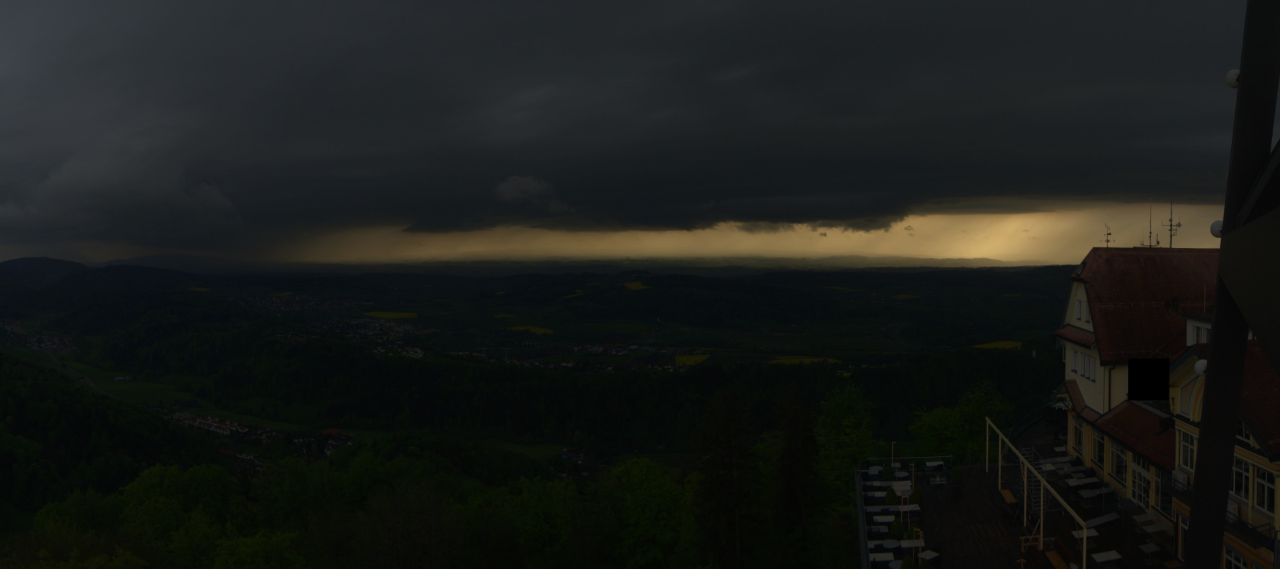
Looking at all the pics of the skies, the remind me of the "loaded gun Sky", tightly capped environment. Have been trying to get hold of some balloon soundings, Herstmonceux for example, but no luck. Can somebody in the forum who has better access post one if possible? Would be a valuable nowcasting tool at the moment..
Regards
Ralph
-
Quote Brickfielder: "So all the ingredients are there in different places for a severe storm, they just don't quite come together on this modelling output"
Indeed, looking at wrf it seems to be only the south east half of the UK for the action and also that the event will take place in two phases. Dont hang me if I havent nailed it down correctly tomorrow but I would say that phase 1 is in the am hours, starting south of London, moving over the East of the city at around 9am and then skirting the coastline in a northeasterly direction eventually to move out over the North Sea. Phase 2 should be the formation of convective activity just north of London at about 2 pm and moving via Cambridge in a more easterly direction. Ihe convective activity could possibly extend as far north as Hull in this instance. In both cases we should be expecting multicell storms. This means that Norwich for example could get action twice tomorrow, others lose out completely....
Thats my 5 cent to the forecast, but dont bet on it
Regards
Ralph
@ Davethedog
-
Hi@ all
Nice to be seeing is the first installation of moist air in the upper levels. France appears to be quite dry atm except for Mediterranean influx moving in from the south east gradually. May take a little time till some major storms form in south and especially central France. What makes me think though is the pronounced clockwise rotation (Satpic) of our long awaited "plum" over the Bay of Biscay, hmm....
Nowcasting time, ey?
Regards
Ralph
Edit: Keen to see the results oft the latest Herstmonceux sounding
-
- Popular Post
Evening@all
quote Spikecollie: " Could be an interesting flight into LIG on Thursday evening, we'll see..."
Heheh
dont forget you may need a barf bag, and please dont forget the camera, if that pans out the way I think then I would give a small fortune to be aboard that flight also.....I am currently in Germany and a bit east, where a Cape loaded but well capped atmosphere is forecast for the end of the week. once the cap gets bust (even regionally) then whambo. A scenario may develop like on the 13th of May where a F3 tornado which started in France tracked all the way through the Black Forest and ended close to Lake Constance, a track of 55 Km. Luckily over sparesly inhabited area, no casualties. Incredible for a tornado to move over mountainous terrain, and even if this is a bit off topic, I would like to post a piccie of the swathe of damage it caused which I made exclusively for you netweather community guys and girls:
This link shows an aerial photo of the same place, I was standing to the left of that small undamaged looking "oasis" facing toward the lefthand bottom end of the pichture when
I took the photo:
http://www.sturmforum.ch/forum_uploads/inprivat/20150518_012330_Cyrill.jpg
Here is the link to two pics taken by a fellow chaser of the massive supercell which spawned the tornado, from the Black forest facing west toward France
Done a lot of chasing, not only in Europe but also in Canadas tornado alley Alberta and Saskatchewan while working there, but this anvil must be the outright most wicked looking supercell I have ever seen, somewhat scary. You could see it constantly flickering and the static on the AM radio was nearly drowning out the local station, meaning plenty hail. Was going to go chasing myself into the black forest but opted to stay in Constance and let it roll overhead, cause you dont want to be poking around in the middle of the dense woods at night with a tornadic supecell bearing down upon you, and only little winding gravel roads leading away to safety
For those who understand German, here the link to an analysis in the Swiss weather forum with plenty more pictures and mapping, the photos alone are worth looking at:
http://www.sturmforum.ch/viewtopic.php?f=2&t=9427
Anyway, sorry I rambled on for so long off topic, but thought I would share this with the community here. Back on topic: there is talk of crud spreading across the Channel from the convective activity over France, Lukey (Surrey) posted this. I would say we wait till Wednesday or so and then have a peek at the charts regarding wind direction in the upper levels, possibly things will pan out ok, lets see..
Regards
Ralph
-
19
-
Hi@all
Re: Tornado near Rostock: 30 people injured, and also 1 person killed in a seperate incident near Hamburg. The town hit by the Tornado is called Bützow and there is some amazing footage taken by a R/C model Helicopter here:
Place looks like the allied bombers paid a visit last night and dropped a couple of Blockbusters, looks just like 70 years ago
In this news article there is mention of three houses being uninhabitable, that the local hospital and an old age home also sustained substantial damage and that the entire historic town centre being cordoned off. The tornado apparently was an F3, and luckily the more densely populated Rostock was spared. Poor people..
I am quite surprised that there was so much violent weather close to the triple point of the front (cold front-warm front-occlusion), was actually speculating on some additional good action in southern Germany as foehn induced clear skies with temps close to 20 deg. Celsius at 850 hPa were forecast ahead of the CF. Unfortunately it was overcast all day, only one large cell formed near Zurich and made it all the way to Munich. I am currently working in southern Germany but didnt bother go chasing yesterday.. Here a link to a piccie of the storm near Zurich for those who may be interested:
http://www.sturmforum.ch/forum_uploads/incoming/20150505_182739_Cedric_frei.png
Will keep you informed if any additional news or insights to the Rostock tornado surface.
Regards
Ralph
-
4
-
-
@ Harry and Greenday:
Yes, indeed it is beginning to look as if the coming weekend will herald the start of some serious convective activity for a change. The model runs are becoming more and more conclusive in suggesting a change over to more unsettled weather during the WE and next week with the passage of a number of consecutive troughs (April weather pattern, hey
)The strength of the spring sun should aid in creating some good convection, indeed something to look forward to..
Regards
Ralph
-
Hi @ all
Interesting upper level low with its centre about to cross over East Anglia in a westward direction. It is curcumventing the surface high pressure area north of Scotland. Is clearly visible on this Satpic and could possibly lead to some convective activity over land. Lets keep an eye on it and find out
Regards
Ralph
-
2
-
-
Hi@ all
Impressive thundersnow event over parts of Netherlands and NW Germany. Lucky buggers there
Regards
Ralph
-
1
-


 dont forget you may need a barf bag, and please dont forget the camera, if that pans out the way I think then I would give a small fortune to be aboard that flight also.....


Storm & Convective Discussion - 1 September 2015 onwards
in Storms & Severe Weather
Posted
Not bad, nice funnelclouds (thumbs up) Wheredyou take them, Lukey?
Regards
Ralph