


Smiler1709
-
Posts
295 -
Joined
-
Last visited
Content Type
Forums
Blogs
Gallery
Events
Learn About Weather and Meteorology
Community guides
Posts posted by Smiler1709
-
-
6 minutes ago, vase1234 said:
Thanks for the reply, but those charts are not in the reliable, as per my previous post. There's always potential in any chart. Cheers.
Actually the charts show a great outlook for our winter prospects if cold is what you like, past day 6 we look for trends, the trend is there's a very disorganised vortex with blocking high pressure setting up ready for the start of winter.
-
 8
8
-
-
2 hours ago, Ice Day said:
Just thought I'd benchmark today versus the same day in 2010 (our last proper winter snowfall, in the SE anyway). The differences are quite incredible.

There is significantly more snowfall this year than 2010 but sea ice is still lagging behind. It would appear simplistically that this is a positive sign for those wishing for cold weather. It's going to be fascinating watching the next few weeks unfold, but my early season optimism for a 'seasonal' winter is still very much intact.
I'm on the fence with this one mate, what we have seen through this autumn is a very disorganised vortex therefore allowing the colder air to sink south and giving Russia and Eastern Europe a winter taster. I really hope it's a thrend for the winter ahead but with signs of the vortex becoming a little more organised it wouldn't take much this early snow advance to melt. Early days but it's a great start.
-
1
-
-
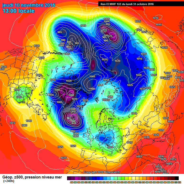
7 minutes ago, Ravelin said:
One thing for sure, when one model is showing this at d10....
And another is showing this....
The FI is going to change!
I'm not even sure there is a half-way house between those two.
Lovely 240 on the ecm, my money is that low taking a south eastern track as it bumps into the block over Scandinavia creating a biter feel to the uk, maybe to early for snow but a great shock to the system.
-
I've been going in the mod threads everyday watching the excitement build, in all honestly I think some are getting way ahead of themselves concerning the high blocking and weak jet stream. would love a cold snowy winter but reality is it won't be. I will put money on that the vortex will of sorted its act out by mid November and the Atlantic will be full steam ahead as we enter December, the season for my thinking is our seasons seem to of shifted the last few years we now get summer later so on with autumn and winter, I believe all we are seeing now is an Indian summer effect with the northern hemisphere not quite getting its act together. I hope I'm wrong but every time I go into the mod thread I'm just waiting for the normal service to begin.
My my prediction for winter 2016/17 will start on the chilly side with bouts of warm air from Spain, rain levels to remain low through late autumn. I expect things in the northern hemisphere to sort itself out and return normal service with a organised vortex dictating our winter weather with a westerly based theme but with bouts of cold outbreaks from the north. Rainfall amounts will catch up on recent low totals.
Hope to god I'm wrong because my little girl still haven't seen snow and I've promised to build her a snowman but in reality I think i will have to go somewhere on a winter break to build her that snowman.
-
Amazed how little snow Alaska has seen
-
Does anyone have any information on how the cfs is performing for the winter ahead?
-
1 hour ago, 40*C said:
Well it didn't last long - BBC weather for the week ahead is hinting a return to northenlies from end of next week. Back to square one we go
Your talking nearly 1 week of weather before any change, they might as well jaffa cakes in the wind when it comes to predicting weather that far out. It will change
-
1
-
-
Some people are absolutely ridiculous, it's one run against the lot. Will change by tomorrow morning so have a chill pill and go to bed. Great evening of informative model info, and fantastic cold charts. Lovely stuff. Night all.
-
9
-
-
1 minute ago, mountsbaysnow said:
well if it does it would be an epic come down and i will cry
You and me both mate, but why to trust the models now when they have been behaving so badly over the last year.
-
1
-
-
So the big question is, can the models with all the background signals and all the agreements suddenly drop this huge swing to cold?
Absolutly great to see such cold charts but with all the sudden downgrades over the last few years I'm just worried this could all go bang still.
-
1
-
-
We all know the gfs loves the Atlantic so when it has churned out a few runs of more Atlantic driven filth it's not really a surprise. Good thing is the Russian block is still in place and there will be swings west and east as to where it will make base. Remember we're looking for trends not a forecast of what will exactly happen on this or that day. Again people need to look at the bigger picture which is the northern hemisphere is changing as we enter January so all to play for.
-
1
-
-
56 minutes ago, Radiating Dendrite said:
GFS 6z is a fairly similar run to the 18z. I may not have a meteorology degree but the problem is surely the fact that the high pressure is not a true scandi one but much further to the north and east. It never ridges far enough West to engage any low and send it SE into Europe. We are stuck in no man's land - looks a similar situation to a few years ago when Europe went into the freezer but we were too far West of the pattern and never tapped into the cold.
This is the scenario that I think will play out this time next week. Big Siberian high to Far East to give us any true cold, I want cold as much as anyone but you need near perfect model output to get cold and snow to our little island especially to lowland England. Hopefully we at least become drier so the poor people affected by the floods can get some much needed relief.
-
1
-
-
People need to step back and see the general trend rather than taking each run as gospel. Each run will change for good or bad but the general trend for high pressure to the North East is building. So much more interesting model viewing.
-
8
-
-
26 minutes ago, Jason M said:
Meto looks good, Gem very good. GFS, GEFS and ECM not so good.
still in the balance this morning but my own gut feeling is that this one is moving away from us. Gem does have some support from its ensemble suite but not enough for us to have much confidence. GEFS are mostly near misses.
Moved away from us? It was never there to start with mate, all the hype for charts that are 200+ hours away, when in reality models struggle with t72 hours. I think we will get a block but it will rest over Siberia and the only benefit to us will be the Atlantic steam train slowing down.
-
2
-
-
even if the euro/Scandi materialises and we do get a flow from a more continental feed, it won't be much cooler than what we have currently, Europe is having a horribly mild winter also so we really are gonna have to have a big pattern change overall to get the northern part of Europe cooler/colder.
Really need to lose those heights over the Med. looking bleak at the moment for any sustained cold. We can only hope things change come January.
-
- Popular Post
Does make me chuckle when I read people saying the 6z gfs is a downgrade on the 0z 'with highs of ONLY 33-34c!!!!' .
What world do these dreamers live on? 33-34c is roasting for uk values. The word 'ONLY' should never be used in these circumstances lol.
-
13
-
hmmm... is it just me or are some posters trying to put an overly negetive spin on the outputs, even to some degree of glee?
overall, there a lot of high pressure dominance/influence, its never far away, with anything unsettled or/and cool being transitory. yes we are likely to get a cool northerly next weekend, so what? its not expected to last more then a day or two before more high pressure re-builds. frosty illustrates this by posting the mean charts.
we currently have a very promising 5 days odd (away from the north today) of dry, fresh, sunny, weather with temps average or there abouts (according the the bbc weathermen). whats not to like? and theres a strong promis of more to come after a blip or two.
i reckon theres a damn good chance of something hot emerging sooner or later, as long as we are dallying with high pressure at this time of the year, its only a question of time imho.
Spot on mate, it's the usual lot that post charts 6-7 days away thinking thats the way the weather is going to pan out, when in reality the models struggle with any consistency past 3 days. What we do have is 4-5 days of settled weather for us all to enjoy. Whatever happens next is anyone's guess. There's a certain few who seem to enjoy putting a negative spin on things. Easily ignored though.
High pressure is never far away in summer and even if we do get a unsettled spot, it doesn't last long and things often settle down before you know it.
-
6
-
-
http://www.meteociel.fr/modeles/gfse_cartes.php?mode=2&ech=204
just had a look at possible weather in fantasy world first week in June looking wet at the moment!!!
Thank god it's pointless looking that far ahead then isn't it.
-
1
-
-
Top comment sea side, people are really over playing this up and coming cool spell. I reckon are still be in shorts next week. With high pressure close to the south it won't take many tweeks for high pressure to have more of a influence.
-
1
-
-
Charts have taken a tumble again today by the looks of it, it looks cold at night next week and maybe the chance of snow on hills up north. Not what we want really considering we're in the time of new arrivals in the animal world. Lots of lambs will struggle if temperatures get that low, and wild life in General will struggle. Here's hoping it doesn't turn our that cold. Still think there's time for change in the models, time will tell but one thing for sure is it will be a shock to the system if these charts verify.
-
2
-
-
Bets on the ECM backtracking tomorrow and resting this silly idea of bringing in a cool blast. All winter we had some banging charts on offer at T92 hours yet 99% of them disappeared when a model picked up a new trend. The gfs has picked a new one up this afternoon and I think it's a safe bet that come next week, it may be cooler and abit wetter but none of this wintry blast cobblers.
-
1
-
-
- Popular Post
And as fast as the cold, rain and wind appears, the gfs wants to send it packing. Fingers crossed this cooler spell is a blip and we can continue on with this great spring weather.
-
14
-
These precipitation charts are hilarious, most of the precitstion that will fall will be wintry mix, more likely to be rain and abit of sleet. No snow cover away from the highest ground in Scotland, really don't see the excitement, with the longer days and the strength of the sun getting stronger day by day this will in turn be another dull, wet and windy spell that we can stick in the bin with the rest of this winter cold snaps. Countdown to spring has well and truly begun for a lot of us.
-
3
-
-
Bring on the cold N/Westerlies and snow showers.Spring on hold for the forseeable.
This really is comical, that's 10 days away. Likely to see pigs fly before that comes to fruitation.
One thing that has been a constant theme this winter is the classic Stella charts in FI but when we get to the reliable we get cold rain and watered down upper 850's.
Also even if that chart did come off, with the strength of the sun and longer days at best your get tempory slush cover in favoured spots. All in all completely pointless. Would much rather have calm cool sunny days.
-
2
-


Model Output Discussions 06z 04/11/16
in Forecast Model Discussion
Posted
Actually looks good to me, it's not about the here and now it's what lies ahead, there's no reason why the Azores high couldn't link with the Scandinavian high, the theme continues, blocked, dry and no sign of the Atlantic.