


Bazray
-
Posts
321 -
Joined
-
Last visited
Content Type
Forums
Blogs
Gallery
Events
Learn About Weather and Meteorology
Community guides
Posts posted by Bazray
-
-
3 minutes ago, Catacol said:
The vortex remains in serious distress - so while the reversal is set to end a bit early it never recovers to anything significant and indeed starts to slow down again by 6 - 10 March. What's left of it set to shift from Canada to Asia in the next 10 days.
What this means for us, in the context of such high arctic temperatures, a signal for continued blocking, and cold air in situ is a bit tricky. I suspect the vortex relocating to asia, with very little signal for an atlantic recovery, means we could see yet more cold filter towards us from a northerly. But in order to cash in fully we need the pattern of next week to hold on long enough that the reinforcements from the north meet a cold pool still in place. Feels a bit like the "Bridge Too Far" operation - cold over the UK battling to preserve its position while the tanks attempt to arrive before warm air overruns the position.
It will be a fine run thing, but the greatest asset at the moment is the MetO text. This same text forecast actually picked up on the potential Thurs/Fri blizzard a long time ago - and the fact that it is holding to a cold forecast suggests to me that MOGREPS is less keen than the publicly available models (that are not run at such high resolution as MOGREPS) to see systems from the south come back north.
I confidently stated that there wont be a breakdown on Friday. Sticking to that... but a little less happy than I was yesterday with that prediction. But these sorts of wobbles are part of the forecasting fun - I was a bit concerned a week ago that the really cold air would miss us to the south as the models flirted with that idea for a day or so. They soon dropped it. Hopefully the same again here.
Well you have called it with breathtaking accuracy so far. Far as I am aware you called this SSW event many weeks ago and remember when you said it may go South, then the models almost did, so if you say it wont break down on Friday it probally wont lol. Yes hopefuly just another wobble.
-
 1
1
-
-
9 minutes ago, Catacol said:
Yes - running my various links quickly tonight I'm struck by the speed with which the models have suddenly decided to move things on. I suspect it is over progressive. Also dont think the storm track will so quickly recover its standard latitude - have you noticed that temperatures on average in the arctic are currently what we would normally expect in June? So much warmth there means an awful lot of cold heading south, and inevitable storm track impact.
However sad to see the SSW end 3 days earlier than forecast a few days ago
Im not really very knowledgeable about weather Cat other than what I have picked up from this forum in the brief periods I visit (usually when snow is forecast) But yes I did notice that the temps have increased rapidly in the artic, almost a role reversal. Did the second phase of warming not kick in recently and any idea of what impact that may have later down the line?
must say also will be amazed if the models have not been over progressive, it just does not make sense to me that a little low can fight off such a cold pool. Time will tell I guess.
-
2 minutes ago, Ashme said:
Nooooooooo!! That means I gotta put my mankini on and go out in it ????
Hope you kept the reciept for the Quad bike lol
-
9 minutes ago, Catacol said:
Hmmm - call a spade a spade... but charts and indications tonight are less good. SSW suddenly set to end by tomorrow, and strat forecasts very quick to move the upper forcing for the north atlantic high to a very west based position by week's end. I would imagine that op runs are putting 2 and 2 together on this basis.
It looks a very swift transition to me in the runs - curiously swift. Not time tonight to post any specific charts - but fingers crossed it is a signal that is being picked up and moved too quickly... and that the MetO text, updated only a few hours ago, means that MOGREPS has stuck to its guns and modelled the speed of change more accurately. More tomorrow - hopefully models will swing back.
Hopefully the Cat is rignt here, lets not forget the models don't make the weather, they just predict it based on a bunch of man made algorithms - the scope for the models to be wrong is a lot more than the met office who give thier forecasts based from models but crucially with a human interpretation.
-
 1
1
-
-
2 minutes ago, AWD said:
To try and summarise this week in simplistic terms.
Monday - mainly dry across our region. Bitterly cold in a raw easterly wind. Isolated snow flurry along English Channel coasts later in the day. For most of us, sunny but very cold with temps just 1c - 4c.
Tuesday - even colder than Monday. Bitterly cold, exasperated by an extensive windchill. Starting dry for most of us after a hard overnight frost, but as we head into the afternoon, snow showers will start to enter our region from the east. A more clustered area of showers may traverse our region from the NE, heading SW late into the day and overnight, providing a small covering for a lucky few of us. An ice day for many if us.
Wednesday - the coldest day of this cold spell. Bitterly cold with a bitter windchill. A covering of snow may greet a lucky few of us from overnight snow shower activity. The day will start dry and bright but snow showers will quickly traverse our region bringing yet another small covering to some of us. This is the day snow showers will be most frequent across our region. An ice day for many of us.
Thursday - another bitterly cold day, although not quite as cold as the previous couple of days. A hard frost will greet most of us. The day will be much drier than previous days for most of us as snow shower activity decreases ahead of frontal activity approaching from the S/SW. Later in the day, some heavy frontal snowfall may encroach into southern most districts of our region. Temps for most, 0c - 3c.
Overnight Thursday and into Friday - obviously due to the timescale involved, confidence decreases here. Current indications favour a spell of significant, disruptive snowfall for many of us in gale force E/SE'ly winds leading to blizzard like conditions for some. The snowfall could lead to localised large accumulations causing immense travel and infrastructure problems. Later in the day, snowfall may turn marginal, or even to rain across southern most counties of our region as maritime air starts to mix out the cold continental airmass of the week. Temps 0c in the north of the region, 2 - 5c in the south of the region.
?Thank you very much for that ?
-
1 minute ago, khodds said:
I have a good feeling it’ll all be ok. Don’t worry folks
")
Me too
-
1
-
-
15 minutes ago, Nights King said:
Thanks for cheering me up somewhat after just getting in from work i was like
Maybe the pub run will steady everyones nerves just like a good trip to the pub will help mine
Cheered Me up too - thanks AWD
and lets not forget the met office with thier world class team of experts and multi-million pound computers are still on board the Siberian express - It seems any mad spell of weather almost comes as a bit of a surprise. The weather it seems can make a fool of us all.
Guess the term it changes like the weather is very apt here, lets hope we get the best case scenario!!!
-
1
-
-
Correct me if i'm wrong here, but am I correct in thinking that if tonights charts verify (worst case scenario) then that could lead to a situation of the moist air from the atlantic hitting the frigid european air that is already in place and readily turning to snow, potential for blizzards - if that is the last hurah of the winter and then we move into spring, that is actually a pretty decent consolation prize right?
-
1
-
-
you can't walk the path to heaven without hitting a stone
p.s does anyone want to buy some cheap salt, anti freeze etc?
-
4 minutes ago, Catacol said:
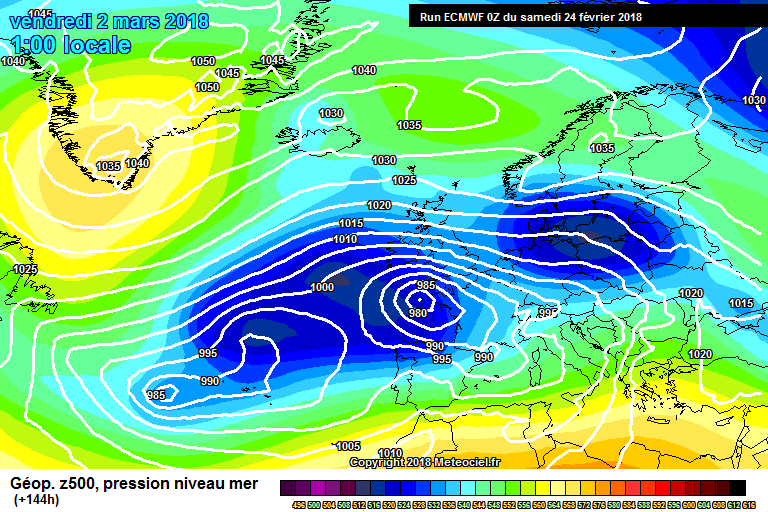
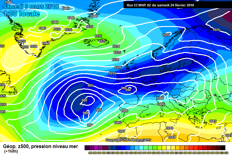
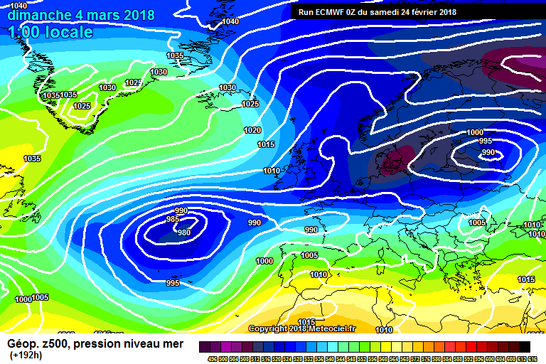
Hmmm - ECM absolutely buries the South West on this run. Less than a week out now. I would very much like ECM to have one of its good forecasting weeks because if it is getting this nailed then we are about to have the biggest snow storm down here in a very long time.... Anyone fancy near on 3 days of constant snow from a stalling system??!
3 days of constant snow? Yea go on then, you have twisted my arm.
-
Well another day of model watching and another day of upgrades. I Remember when I heard about this SSW event about two weeks ago and have been hooked ever since, think it was one of Catacol's posts a few weeks ago that caught my interest, at that point it seemed a real long-shot but being snow starved, just the chance was enough to peak my interest.
At that point two weeks ago who could have imagined we would be sat here today, the Beast from the East staring right at us and about to send us into the freezer for a few weeks. Told a few of my mates at football last night and there was a few sniggers, think they thought I was losing the plot lol, but can say with a high level of confidence I will get the last laugh on that one
We move into the fun part now, the radar and lampost watching and that exitement that brings!
Hope you all get absolutly burried and manage to stay safe and warm.
-
5
-
-
7 hours ago, Daniel* said:
I dont think we will get any warnings till we move into the reliable timeframe, which Should be over the weekend / early next week. Looks like lots of positive signs of being the right set up for good convection for us guys though.
Fingers crossed eh!
-
1
-
-
22 minutes ago, Rich_Clements said:
Daft question how can I attach a photo from my phone into a post??
Cheers in advance
Can you see the little paperclip icon below where you are typing on the left it says 'click to choose files' select that and it should take you into your phones pictures to select the one you want.
Thats how it works on mine anyway.
-
So another day of ups and downs, looks like for once us guys just might be sat in what could potentially be the sweet spot for this upcoming event with a bit of leeway for the constant change seen in the models. Guess we deserve that after seeing the whole of the winter pass with everything going North of the M4
All looking good at the moment (till the next run at least)
have spent way to much time on the MOD thread today so I'm off to do my hourly breathing exercises and sit in the praying mantis position for a few hours.
-
2 minutes ago, EllyTech said:
High pressure systems tend to move clockwise so we will look at the isobars to see what direction the fetch is from; for example, from a cold pool. The closer the isobars the windier the conditions. So a slack High Pressure would have isobars quite widely space out. This would give calmer conditions at the surface.
Thank you, very helpful. One last question.
If there is an area of high pressure, and an area of low pressure, then the high pressure area will move into the low pressure area.
for example a high in siberia and a low in england, the air from siberia will travel to england
is that somewhat correct?
-
Would anyone be kind enough to explain to me the role the isobar plays on a weather chart please.
Does it indicate the source of the airflow and the direction the air (wind) will travel
and also what is the difference between a tight and loose isobar and what effect does that have?
An explanation for dummies wil suffice ?
Thank you ?
-
1
-
-
So after this afternoons little wobble, its back on and has gone heavy metal!
Not to sure I can handle another week of this, might need to take up meditation or deep breathing or something.
and relax.
-
Just now, Nights King said:
Cold pool seems to be constantly increased and deepen with each day.
Another stellar run!
Its quite remarkable! Kind of programmed to expect the worst living down here, but this time things just seem to be going right for once.
*touches wood and crosses fingers and toes*
-
2
-
-
12z another absolute cracker! The stars are aligned
-
4
-
-
Eyes down for the 12z!
-
2
-
-
5 minutes ago, Bristle boy said:
Give me 'today' over cold and dry anyday.
Had our garden completely madeover last few weeks so i've just spent an hour or so breaking up old stuff to take to the tip. Outside our front of house is a suntrap this time of year and it is beautifully warm in the sun, out of the wind. Sat here with a cup of tea soaking up the sun
Sat here in a short-sleeved shirt.
Yea give me today over cold and dry any day of the week, cold and snowy on the other hand, no choice there.
-
The televised weather reports so dull and boring, We have one of the most exciting weather events coming up in at least 8years, one that has the potential to be a record breaker and all they can say is it might get cold and icy. Am not asking them too exaggerate or anything but at least expand and explain what is going on and explain the potential this Easterly has.k instead they prefer chatting about bloody KFC running out of chicken :s
maybe the forecasters are instructed to downplay it a bit until things firm up for the risk of not causing unwanted panic?!
-
3
-
-
2 minutes ago, Mark Parsons said:
This is turning into a shopping thread ??
Ha ha, exacly what I thought, women and shopping, any excuse ?
-
Forecast summary
Outlook for the UK over the next 6-30 days
UK Outlook for Sunday 25 Feb 2018 to Tuesday 6 Mar 2018:
Sunday will be dry but cold for many, with some sunny spells. Snow showers may develop across eastern and southern areas where fresh winds will make it feel bitterly cold. Through next week it is likely to become even colder with strong easterly winds, bringing an increasing threat of snow showers. These will be heaviest and most frequent in central and eastern areas, and some spells of more prolonged snow are possible at times, particularly in the east but also perhaps in parts of the south and southwest. The cold weather will continue through the rest of the period, with the northwest seeing the best of any brighter weather, and here it may be less cold at times, although brisk winds will continue to bring a marked wind chill.
Updated at: 1200 on Tue 20 Feb 2018
UK Outlook for Wednesday 7 Mar 2018 to Wednesday 21 Mar 2018:
At the start of this period it is likely to remain cold or very cold for many with widespread frost and brisk easterly winds from Continental Europe, making it feel raw. This will continue to bring the risk of significant snow across some southern, eastern and central parts of the country, whereas towards the north and west it will be drier. As we head through the middle of March, there is a lot of uncertainty in the forecast, but it may start to turn more unsettled and less cold with the wettest and mildest weather spreading in from the southwest. In contrast, northern and eastern areas could remain colder well into March
Updated at: 1200 on Tue 20 Feb 2018
-
1
-


")


South West and Central Southern England Regional Weather Discussion 22/02/2018 Onwards
in Regional
Posted
My take on it, if you put 2+2 into a calculator the result will always be 4. Computers / Calculators / Algorithms are clinical and correct when dealing with facts.
problem is with weather, is there are never any firm facts to enter into the calculator, a little change here or there can have massive implications in the end result, hence why we can never predict the FI with any real degree of certainty. So thats my excuse why I will ignore the last outputs until they show what I want (about 9 feet of powder snow)
Anyway thanks Cat, whatever happens been a real education reading ypur posts, Thank You