


Barry Reynolds
-
Posts
214 -
Joined
-
Last visited
Content Type
Forums
Blogs
Gallery
Events
Learn About Weather and Meteorology
Community guides
Posts posted by Barry Reynolds
-
-
NEVES SCREAMER Yes, very spring-like today in Hereford. Bright sunshine for a while, I could feel the warmth on my face.

-
 3
3
-
 1
1
-
-
4.3c and 45mm, thank you.
-
1
-
-
Much as the models have delayed any real chance of cold, so the Met Office outlook continues to say a higher chance of cold, but always in the later period. Plenty of caveats in there too. We shall see.
-
2 hours ago, Herefordweather said:
Can’t see the showers even reaching me in Hereford let alone South Wales. Can see this cold spell being disappointing snow wise for us
I'd say the 06z GFS is ok for snow for the Hereford area Thursday night - Friday. Milder air being held back a little? Snow depth looks ok by Saturday.

-
4 minutes ago, Connor Bailey Degnan said:
Beautiful ecm mean, phew
How does this compare to yesterday's? Does this suggest the op is one of the 'milder' solutions?
-
2
-
-
27 minutes ago, Roadrunner said:
Was there a SSW prior to February '91? May have been answered previously so apologies if so. I also remember around the time we had the snow nirvana that year, the Eastern seaboard of the USA had quite high temperatures for the time of year. May mean nothing at all - then again my knowledge is very limited!
Yes, apparently so, as Judah Cohen was comparing similarities with the split vortex then, to the forthcoming one. He mentioned it on Twitter.
-
3
-
-
17 hours ago, Terminal Moraine said:
Hi Barry, you could try contacting COL ( Climatological Observers Link ) https://www.colweather.org.uk/index.php
and advertising your barograph there; it has several hundred members so someone might be interested. If I didn't already have a barograph I'd put an offer in myself.
Thank you very much!
-
Hi all,
I have a Barigo barograph bought in about 1990 which is in perfect condition, apart from the odd miniscule scratch. It is housed in a mahogany case. I do not have any paper or the pen, but these can be bought. Last time I looked, a new one would cost about £1000.
I need to sell it which isn't that easy, can anyone suggest where I should sell it? I have tried eBay, but there was no interest.
Thanks!
-
Well I've been enjoying working outside in the last two days of sunny-ish weather. Looking forward to the first 20c in hopefully not too distant future. Then some proper summer heat and storms hopefully. If I can't have snow, that's the next best thing!
-
1
-
-
HI all, is it unusual to have 100% ensemble agreement for an upcoming SSW?
-
I do wonder whether an Easterly is possible, the ECM keeps picking it up, and the METO update today seems full of uncertainty. Perhaps they haven't entirely discounted it.
-
2
-
-
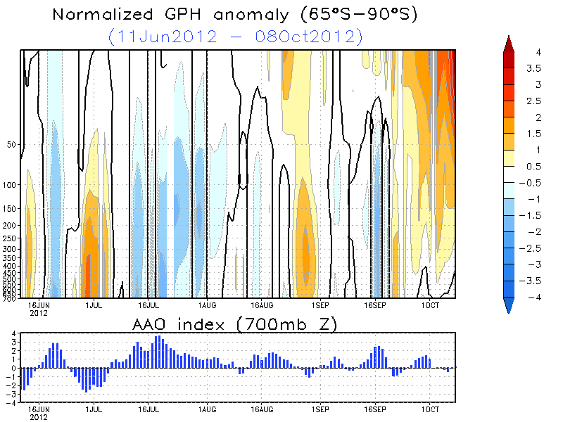
1 minute ago, SN0WM4N said:
Examples help
It follows the bottom chart in relation to AO so the orange colours indicate polar heights with the latitude on the left and the time on the bottom.
Thanks Snowm4n. Good example, far easier to understand.
-
1
-
-
1 minute ago, CreweCold said:
I don't know about Hovmoeller plots, but I think a lot of people have been driven to losing said plot over the past couple of weeks!
I looked it up......."A Hovmöller diagram is a commonly used way of plotting meteorological data to highlight the role of waves. The axes of a Hovmöller diagram are typically longitude or latitude (abscissa or x-axis) and time (ordinate or y-axis) with the value of some field represented through color or shading."
Now I will have to read that again and think about it for a few days before I can tell you what it means!
-
7
-
-
Just now, KasimWeatherQuarnford said:
Dec 2015:
Dec 16:
Hmmm....I have to say the comparison with last December is closer.
-
8
-
-
Of course. Every evolution has a knock on effect. But the chart I referred to in Paul_1978's post shows how the knock on effect could be a good one.
-
2
-
-
40 minutes ago, Paul_1978 said:
Well well..... South Westerlies at T+201 becomes Westerly/North Westerly by T+225, and a sinking low and Easterly by T+276 and the Atlantic starting to look blocked again.
Perhaps today hasn't been so bad after all?
Exactly. Does it matter what happens next week? Its the evolution thereafter that counts.
-
1
-
-
- Popular Post
- Popular Post
15 minutes ago, fergieweather said:EC Monthly consistent with Glosea and it's last runs. Strong resurgence of +ve MSLP/GPH anomalies north of UK further into Dec, especially Xmas week, with marked -ve temp anomalies developing across adjacent contiguous Europe as N'ly flow veers to mean easterly late Dec. Good to see both suites in such firm agreement, despite inherent issues of confidence at such lead time.
Am I dreaming? Good agreement between suites, a mean Easterly flow, heights to our North, and Christmas week. How often are those 4 things together in one paragraph? Can't get better than that at this range.
-
16
-
25 minutes ago, Frost HoIIow said:
It's already here. OK it's not what most of us in here including me would ideally want (deep cold and snow) & some may call this "faux cold" but non the less it's still cold with a hard frost expected tonight and temps struggling tomorrow in the low single figures. Much better than rain, wind & mild temps.
True enough. Colder temperatures tonight and tomorrow night than 99% of nights last winter! But, yes, a blizzard would be better......
-
5
-
-
I hope that the cold when, or if, we get it is as persistent as this high pressure is likely to be!
-
2
-
-
Well, the Met Office are still obviously thinking that the 'potential' for cold weather this year is strong. And to be honest it appears to he a blank canvas after the next 10 days or so. Less analyzing the minutiae, more listening to the experts, and the Met Office don't generally jump the gun.
-
I don't post on here much, but I have to say a great forecast Stodge, may well prove correct, especially the first half. I'm going with the most Wintry period of the Winter to be around Christmas. This is based on little more than optimism and gut feeling.
-
Just now, Summer Sun said:
Check back around 22:00 should be out around then and 23:00
Thanks SS.
-
When is the EC Monthly due out? I thought it was today, but not seen any mention of it.
-
1
-
-
13 minutes ago, damianslaw said:
Changeable outlook from todays models, a warm up as we move through the rest of the week, but only back to near average temps by the weekend, with a slow moving band of rain, could be some large totals for some which will be noticeable after such a lengthy dry period. Into next week, high pressure from the azores nosing in with a milder tropical maritime feed, so becoming mild for the time of year,but it looks a shortlived affair, as low pressure swings in from the NW and introduces increasingly colder air as the week wears on, with the northern half of the country enveloped in sub 528 dam air before the working week is out, which would no doubt increase risk of snowfall for low levels - supported by Met office forecast.
Whilst we are seeing the polar vortex set to intensify over Greenland in the coming days, there is every chance given other signals notably MJO that it may not become a significant robust feature, indeed further trough disruption quite likely with the influence of heights to our NE once again pulling the breaks on trough movement eastwards ultimately squeezing the PV from powering into gear and eventually dropping trough into central europe enabling those mid atlantic heights to ridge northwards again and perhaps join hands with heights to the NE - I'm reading between the lines of the Met Office long term forecast, and this would suggest such an evolutionary synoptical set up as we move through the latter part of November and into December.
Short term milder/average conditions for longer term colder prospects perhaps?
I hardly ever post on here, but suffice to say I would be very happy with this evolution. The further into December for cold the better, November won't bring anything meaningful for us Southerners, no matter how good the synoptics.
-
6
-


.gif.2ae5e5139df561d2ba19ab795c235bf1.gif)


When do you predict the first 20°C and 25°C of 2024 will be?
in Spring Weather Discussion
Posted
20° on 27th March, 25° on 30th April