


Ben Sainsbury
-
Posts
2,341 -
Joined
-
Last visited
-
Days Won
1
Content Type
Forums
Blogs
Gallery
Events
Learn About Weather and Meteorology
Community guides
Posts posted by Ben Sainsbury
-
-
3 minutes ago, swebby said:
According to this they have rain/freezing rain

Correct although according to NMM, the positive uppers never really make it that much north than the south coast and so expect majority of precipitation to be snow besides maybe a little freezing rain on south coast.
-
 1
1
-
-
Just measured my snow depths in Keynsham, general consensus seems that (although difficult to measure through snow drifts) that my depths range from between 4 and 9cm.
-
1 minute ago, AWD said:
Bigger flakes here now, nothing major but they are definitely bigger now.
Agreed I mean well we're in the same location so it should, but visibility greatly reduced and still many many more hours of snow, would surprise me if the Met Office DIDN'T extend the area of the red warning.
-
Not that looking at the GFS matters now, but on the 12z much of the red and amber warning areas are under continuous snow till Saturday at 3am!
-
2
-
-
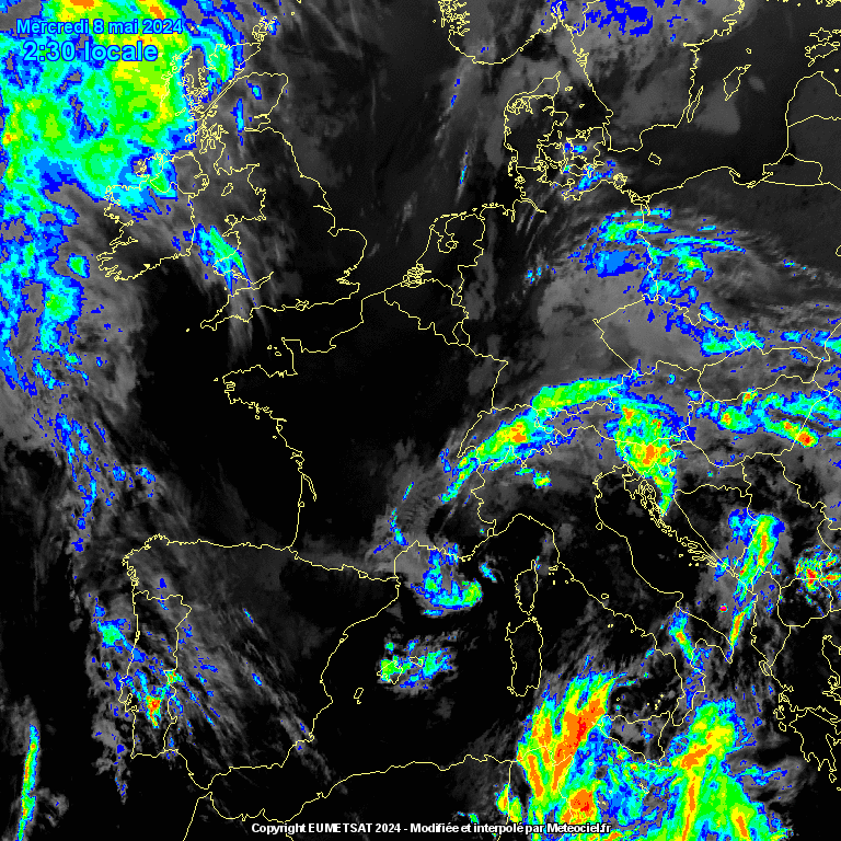
1 minute ago, Bring Back1962-63 said:
http://www.meteociel.fr/observations-meteo/satellite.php?mode=animation-infrarouge-colorise
A few of you are still misinterpreting these charts
The vast majority of our blizzard will not move up from France and Biscay - it will develop rapidly much closer to home in the Channel as the flow engages with our dense cold block and tries to under cut it but rises over it. So watch both the infra red satellite as well as the radar. In about an hour to two hours (1630 to 1730) there will some mind boggling developments. David
Your sir are a magician!
-
2
-
-
Lets hope the heaviest of the snow arrives at the same time as the strongest winds/gusts. These look to arrive around 8-9pm with gusts in excess of 50mph.
-
How are the flake size further south, because currently in Bristol it's still the same dandruff rubbish!
-
1
-
-
To put it under context as well for snow amounts per hour under the dark orange/red, the rain to snow ratio is approximately 1:15 therefore 12mm/hr of rain for example is equivalent to 300mm/hr of snow = 30cm/hr of snow.
Even the light greens of 3mm/hr = 45mm/hr of snow = 4.5cm/hr of snow so to only be witnessing the areas of green intensity can still dump 15-20cm in just 4 hours.
-
3
-
 1
1
-
-
Just now, EllyTech said:
My sensor shows -3.7C
The disbelief comes from not having an historic reference to such a phenomenon.
Very true, only 18 years old so my memory can only extend so far
Surprise me mother nature!
-
I just can't quite see how we're (Bristol area) are going to get 10-20cm, we had 4 hours of moderate snow earlier and amounted only 2cm.
Just don't see it happening, hope I'm wrong and we also get half a metre!
-
1 minute ago, Mark Neal. said:
Anyone see the last few radar returns, precip turned heavier expansively as it moved out of Bristol into Severn into Wales. Anyone around there?
I've noticed too although I'm a bit far south for that, looks like the main area of snow is forming a few light showers ahead of itself.
-
Carol just said there's a red warning for SW England whattt?
Damn it I want a red warning!
-
2
-
-
Current Met Office modifications to the warnings, of what looks like to shift the amber warning to a later start period at 2pm.
-
The flakes are huge here right now, and winds definitely picking up, can't even imagine what it is going to be like with heavier snow later.
-
Looks like strongest wind speeds/gusts should be between 3-9pm, during the period of heavier snow. (Hopefully)
-
2 minutes ago, Bristol_Robin said:
Not much to report in Bristol really . Few gusts of wind now and again . Can see it being a non event here . But I am a pessimist lol
Non-event? You just have to look at the radar to see that isn't the case, a band of light to moderate snow moving in.
I felt exactly about you this morning though, kept waking up having nightmares that we'll have no snow lol!
-
Just so everyone is clear about the Met Office Warnings,
Yellow Warning of Snow is Valid from 8am.
Amber Warning is Valid from Midday.
If we were to expect a red warning, would expect sometime between 12-4pm.
-
1
-
1
-
-
Area of light snow to or south seems to be gradually increasing in intensity.
Um got a covering here and I thought we had no snow??
-
1 minute ago, Nights King said:
Hard to say if that is good news for west country or not..?
Personally to me looks less marginal for us and more comfortably within the band of snow rather than the edge. Really now any eastward shift won't affect us with all that snow to our west.
-
5
-
-
NMM 18z, present another larger eastern shift.
-
1
-
-
My school/sixth form have just closed for tomorrow, something I didn't expect was thinking about Friday.
Chew Valley School for those who wonder. (Near Dundry)
-
3
-
-
7 minutes ago, CheesepuffScott said:
Just looked out the window and it seems to be some light flurries. Here's netweather radar. Interesting.
Few high res models modelled this, probably as a result of moisture advection for the Storm Emma.
-
1
-
-
2 minutes ago, Leon1 said:
love how im just outside the dotted line on the forecast, 1 mile further east please?!
Just to add, Ian said give or take 30 miles or so of white dotted boundaries.
-
1 minute ago, dec10snow said:
Latest from Ian’s forecast
Beat me to it bugger!


South West and Central Southern England Regional Weather Discussion 22/02/2018 Onwards
in Regional
Posted
Our Amber warning is in connection with the highest possible impact, but 2nd highest likeliness surely the Met Office can be confident of another 4-6 hours minimum of heavy snow, the public need further warning.