


Gavin Hannah
-
Posts
1,317 -
Joined
-
Last visited
-
Days Won
1
Content Type
Forums
Blogs
Gallery
Events
Learn About Weather and Meteorology
Community guides
Posts posted by Gavin Hannah
-
-
GFS blowing through in FI....
 Get ready for the long dark... because Winter is Coming!
-
 1
1
-
-
Biggest difference thus far on the 06Z run is the HP failing to link into the Azores, bringing in less of the milder air from the south, allowing the colder uppers to return. LP in the atlantic makes it very interesting.
-
As mentioned by others above, there is cross model support now for the Easterly and it's fast approaching the reliable time frame. But lets wait until we get with t.96 before we start going on about lack of snow or not quite as cold etc. etc.. Subtle adjustments will mean that the broader scenario will remain unchanged (with any luck), and the details will start to become clearer within a few days. Then we can go to town with either a full on snowmageddon, or not.
-
5
-
-
ECM .. What have you done
the GFS setup looks broadly similar at t.216 t.240 I think. North easterly flow bringing colder temps and snow. The questions is where will this HP be setting up shop? Nervous few days coming up I suspect.
-
2
-
-
I think the GFS should be renamed DGH - Down Grading Hopes. Still compared to the abysmal December, the fact that we are now within 48 hours of a polar shot is stained glass windowin remarkable. Cold dreary high pressure has been thoroughly depressing, just about as bad as a year of intense Atlantic weather. My own opinion is that years and years of fine tuning have meant that the GFS is prone to downgrading as 99% of the time, that's what happens. Law of averages right? Until someone can shut off that damn jet stream, then we are stuck in purgatory i'm afraid. On the flip side, as im a glass half full guy, I fully expect the GFS to start behaving from the 06Z run onwards and start developing Easterlies....
-
3
-
-
A lot of bottom of the barrel scratching going on in the model thread. Not one to rant much, but Come Friggin On! Even the Sahara got snow the other day, and it lasted a whole 24 hours! Stop crapping on us weather gods and deliver the friggin goods!
-
2
-
-
Well, see you all next year... Xmas is going to be BBQ weather once again this year. Might as well move to bloody Oz.
-
3
-
-
You step outside for a day or so, and come back to find the GFS raining on our parade.. again. I have the feeling, that if we are to get any sustained cold and snow before Xmas, it's not going to show its head on the charts until the last possible moment. Yet again, we seem to be seeing lots of promise just outside the reliable time frame and then BAM! It's gone a day later....
-
1
-
-
Wow, just clicked though the 00z run 1040mb High pressure .. are you kidding me.
-
1
-
-
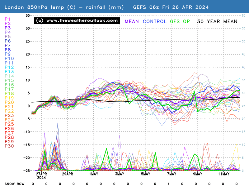
9 minutes ago, Summer Sun said:
06z Op colder than the mean for the 850's that's not to say it won't be cold at the surface may be higher single figures instead of low single figures
Control and mean very close until the 13th
Wouldn't be surprised if after the 7th, lots more members start dipping back down to -5 as we get closer to this weekend.
-
1
-
-
HP is looking to hold out more and more with each run. No snow prospects yet, but it is keeping the Atlantic at bay.
-
2
-
-
Ok so it would appear to me that the cold plunge forecast by the GFS last Thursday, (remember that epic 06Z run....
) is back on? The prospect of snow I think is gone but if i'm not mistaken, from that epic 06z run last thursday? The GFS backed down towards the ECM and now we've had successive runs lean more towards an upcoming frosty weekend? Looking at the 06Z so far, at t.96, the LP in the Atlantic is further south (thats good), the HP over is is more favorably aligned (that's also good). I think we could see a few upgrades in terms of cold as we get closer to this weekend.
-
2
-
-
Well up to t.144 looks good and very consistent on the GFS. Let's see what the mods produce over the next few days as next weekend draws closer. As mentioned, it was never going to be difficult to 'downgrade' from the 06z output. That being said, anything beyond t.144 is still in the unreliable time frame so IMHO, game is still well and truly on. Now watch the ECM produce an absolute belter this evening!
-
2
-
-
2 minutes ago, mountain shadow said:
Yup, game over for any lowland snow in the first week of December, GFS fails again.
We now look further ahead when hopefully those tropical signals GP was alluding to start to show their hand in the output from the 2nd week onwards.
Have you seen the whole output? Coz at t.189 i'm looking at a very interesting LP feature about squeeze up the eastern side of Greenland and the snow risk charts are not too bad for lowland snow at this time.
-
3
-
-
2 minutes ago, snowice said:
To my eye gfs at 162 is following 6z cold a little further north east!
Yup I have to hand it to the GFS. T.144 is near enough identical to the 06z run. It looked like for a minute the NE seaboard / Atlantic lows were going to spoil the party.
-
GFS T.123.... Potential spoiler in the works. Double shortwave off the NE seaboard / Atlantic
-
1
-
-
At t.72 just now, main discernible difference is the slightly stronger HP off the NE seaboard.
-
Just now, Ed Stone said:
Here it comes, the 12Z we've all been waiting for...Is Snowmageddon incoming or not?
Of course it is.... faith you must have....
-
4
-
-
Just now, Changing Skies said:
Rather you *want* that to happen...we've been here so many times. @Weathizard typically they are right, only when it goes wrong it unfairly stands out. Dec is not far off, however likely does not stress certainty but nor does it deviate from from what they're expecting, I seriously doubt the 'experts' even trawl through GFS, amongst more high calibre MOGREPS and what else they have.
You are probably right, but I have a good feeling about this ...
-
I'm sure I joined this list a few years ago? Either way, after this mornings 06Z GFS run can I get really loud "RAMPING!" from everyone!
-
4 minutes ago, Weathizard said:
Honestly people put too much credence in the METO further outlook/forecasts, this is meant in no disrespect but they are wrong just as much as they are right!
The tipping point with this setup is coming soon this is for certain, with it coming into semi-reliable timeframe, I trust the GFS more re: energy in the atlantic and shortwaves but we've seen it has a bit of a tendency to build pressure over zealously.
In summary, I have no clue and this post is about as much use as a chocolate teapot.
I'm sure chocolate teapots have their uses......
-
2
-
-
4 minutes ago, Changing Skies said:
Met Office 'outlook' through to early Dec depicts wet and windy conditions are likely to transverse across the UK through the first few days of December, so you can insinuate they're not following the cold GFS 06z script. ECM is not going to backdown I sense more will be revealed this evening, I wouldn't get your hopes too high for a rather quick or easy passage to a wintry period. Nonetheless they are inclined with a rather cold period heading towards mid month, with HP to North and East, so the gods are in our favour not knocks.
Expect that outlook to change if the GFS / GEM continue their train of thought and the ECM backs away.
-
3
-
-
I am really very encouraged by the outputs right now. How many times have we seen eye candy charts like this and discover it's a complete loner compared with the rest of the ensembles, control etc.. This much broad agreement to me signals that the mods are on to something.
-
5
-
-
2 minutes ago, tight isobar said:
Solid ridge...deep waa eastern seaboard' Atlantic shut off point accomplish.
Deep set pv eastern pole....
Is that the start of a Greenie HP building????!?!?
-
1
-
 Get ready for the long dark... because Winter is Coming!


")


Model Output Discussion 29th December - Into mid-Winter.
in Forecast Model Discussion
Posted · Edited by Gavin Hannah
Next Wednesday - notice how intense Greenland HP is
Then, by Saturday
Hp to our NW and a slack Greenland. If i'm not mistaken, that's a great opportunity for a 'fabled' Greenie HP, if the dice fall the right way. I know it's just one run, but it seems the trend is definitely for Greenland to go slack towards next weekend. Something I don't recall seeing at all last winter.