grca
-
Posts
23 -
Joined
-
Last visited
Content Type
Forums
Blogs
Gallery
Events
Learn About Weather and Meteorology
Community guides
Posts posted by grca
-
-
-
14 minutes ago, Man With Beard said:
errrr, Man with good news and bad news
 - good in that a pattern for cold might develop D11-D15, bad in that the ECM op D7-D10 is a genuine outlier
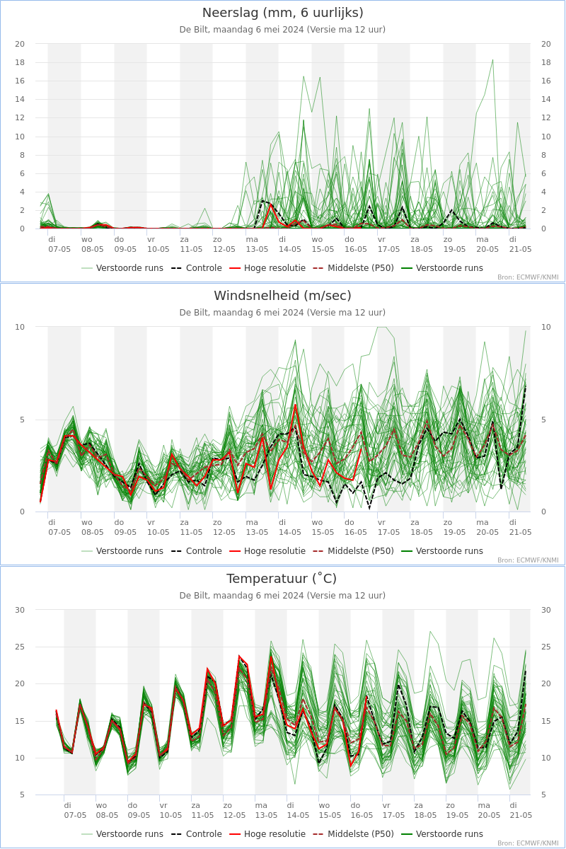
I think it would be safe to say that after the 20th there are a few options on the table... This for the Netherlands.
I would love to know what is causing this uncertainty on such a regular basis in the models, it seems like a weekly drama at the moment - will it / wont it :-)
-
 1
1
-
-
I don't ever comment on the models and what they show on here so be gentle. To me none of the models have got this right yet after days 4-6, what is obvious is that this high over Scandi is not budging anywhere quickly though.
The UKMO has been resolute holding the block but not finding a clean route for the lows to travel into mainland Europe - it does however hold the high in place without any sinking showing that it believes the most likely scenario is for this to remain roughly in place. This has been consistent now for days and most of the other models have been moving towards it evolution recently.
I think the word battleground is not a bad description but not a battleground which is a snowy one (yet anyway).
This could go anyway but in my opinion based on what I can see in the daily output over the last days + some (small) knowledge of prior history of these setups I don't think we have yet seen any model show us the likely correct direction of travel, I also believe that this holding pattern could stretch for a few more days yet with the UKMO for example spilling out the same picture for days 4-6 until it finds the right solution.
Whilst it holds the pattern, in fact the longer this picture holds in my opinion the more likelihood or chances are that we could get the trough disruption into Europe and find the easterly and cold.
Just my thoughts.
-
 8
8
-
-
-
-
-
3 minutes ago, tight isobar said:
Hi Tight Isobar, I am a fan of yours :-) just wondering what you make of the ensembles for the Netherlands from the ECM which have just come out? Does that not imply that the ECM Op is on the cold side compared to the rest of the suite?
-
 1
1
-
-
I am not the best at reading charts and I hope my posted charts show up as I see them on my computer :-)
At day 5 the differences on the Alaskan ridge between the 3 main models we can see look very different, UKMO and GFS the closest and ECM slightly different by not building the secondary ridge behind the first poleward attempt.
The GFS has a more organised low pressure system passing above the UK and the UKMO has a slack low directly over us, the differences I appreciate might just be timing.
To the more learned posters here, would that not suggest that even day 5 currently indicate that this is where FI starts?
-
 1
1
-
-
-
-
Sorry mods, please delete this immediately after reading..way too many Tottenham supporters posting tonight pretending to talk about model output :-) where's all the Liverpool supporters tonight :-)
On topic now, ECM 15 day showing that the op was on the bottom end of the pack, not to say this is wrong and hopefully an emerging trend as this is 2 times in a row.
Apologies just noticed this was the midnight output not the 12Z...
-
4 minutes ago, Severe Siberian icy blast said:
There's no way you can say zonal for 7-10 days is nailed . So when the models were showing high lat blocking after t144 was that likely to happen ? No one can say . Whilst we are entering a zonal spell , we simply don't no when the mods will pick up a pattern change . Like you said the background signals all point to a cold Feb , so let's enjoy watching the pattern unfold .
Let the models settle down and once we are 2 days into it we can then start looking for a quicker response .
Agreed on this, there does seem reasonable doubt at 7 days which could suggest a change to a more NW flow. I have been trying to post the 18z ensembles but for whatever reason I can't. By the 26 / 27th though there is a split which could indicate a slightly different outcome to currently modeled is coming. I tend to work on the lines of when high pressure is shown at higher latitudes (above the Azores for example) regardless of where this is shown it is possible that this could happen. The likely location for where it ends up though get's decided normally closer to the time.
Based on what has been modeled in the last few days, strat forecasts and bias employed by most models I do agree with others that early Feb could see a different outcome to what is currently shown.
I do see a mid Atlantic ridge forming within the next 10 days and hope (as it is not currently modeled) that this ridge will be sufficient in strength and latitude and not blown away by any remnant of vortex left over Greenland pushing the jet stream straight west towards us.
By the weekend we should have a better glimpse of what could potentially be coming in the next 2 weeks, but based on what has been shown by the far more experienced posters like Tamara (not the only one mind you) I am certainly not writing off any potential for a colder last 1/3 of winter.
-
 1
1
-
-
4 minutes ago, blizzard81 said:
Ecm control looks identical to the op and 10 day ensembles go generally very mild. Ecm says alex scuppers uk cold. Thanks alex! Never did like that name!
I would slightly differ with your view there and suggest that the main group remains cold, and there is an even colder group visible too. Remember this is for the Netherlands therefore locally in the UK it could be different depending on location. The op and the control you could say are at the top end of the potential solutions available.

-
 1
1
-
-
UKMO for comparison to GFS at 96hrs..
UKMO

GFS

UKMO looking to replicate it's earlier run to my untrained eye..
-
 4
4
-
-
I was just taking a look through the GFS ensembles at 120hrs and I am amazed at the differences shown within that timeframe. Does that suggest anything after 96hrs (or before even) is far from decided on the GFS that is?
Some examples below
Control -

No 2 (there are many more variations of this theme like this as well)

-
 1
1
-
-
ECM short ensemble for De Bilt - op following the warmer breakaway group

-
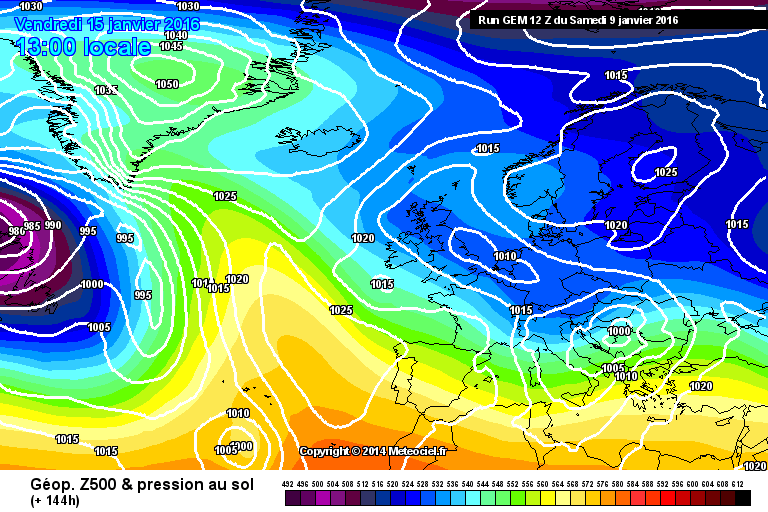
GEM at 144hrs looks pretty similar to UKMO as well...

-
 7
7
-
-
10 minutes ago, Nick F said:
A small amount of scatter on the pressure graph too :-)
-
 4
4
-
-
A quick question for the more knowledgeable to answer, with the scatter on the pressure for London on the GEFS at 4-5 days does that suggest that the pattern is still not determined correctly ? The GEM seems to be very different in it's evolution from GFS especially at 120hrs but there are quite a few GEFS with a similar notion on the low the develops over northern Germany which reduces the higher heights in Europe and allows the cold to come in from the East. Just wondered if anyone else had a view on if this was game over and a return to SW / W pattern or could something pop out of the blue so to speak.
Not posted for a very long time so if the link of the GEFS pattern diagram does not link I will try again..
-
When the various models still show various solutions and there is no agreement is it correct to think that what is shown on each individual op run is going to be correct? It is obvious that currently in the accurate range of the models up to up 120hrs they agree, after this time we have a variation of solutions. Each person on this forum has his / hers own preferred outcomes be it mild or cold be it what they prefer or what we personally would wish.
What we have tonight is a move towards a colder solution which tomorrow could be gone, however in the last 3 days I personally prefer tonight's runs than the last 3 days as potentially we could get some colder and more seasonable weather.
Whilst watching every run of the models and checking every frame of what happens I still cannot pin point the the actual outcome during Christmas week apart from stating potentially it could be mild at times or pretty cold with some snow even in the south which is what various models show depending on which run is viewed.
So as said many times best wait a couple of days before we make a confirmed statement either way.
-
 3
3
-
-
The Artic Ossilation , Ao is going strong -ve i see.
This could be in for spectacuair unpredict weather patterns.
We could be in for a lons periode of colld spells , sometimes for britain an intermezzo for couple of day s ,.
But i dont see the zonale jetstream at al coming for a long time.
Even begin march we could be in for coll artic aoutbreaks or NE , with lot os snow.
Also i notice that doctor Piers Corbijn make some new comments about it.
At 8 februari something will occur at de the nordpool with the solar winds , that wil means that we wil be in for surprises.
Hi Ryan...
Just a quicky, but to my knowledge and I am happy to be corrected but the NAO and AO predictions you are looking at are coming from the GFS output, therefore whatever the output of the particular run (ensemble) that is predicted by that run = the data you see on the AO NAO predictions.
Therefore this is not maybe not the best indicator of the cross model interpretation.
Best check back on future outputs to see consistency, then you have some idea if it is more likely to become reality...
-
Can somebody help me with the latest charts from the AO end NAO , i prefer those from weatherbell charts , but otherwise is also gut.
Here you go:
http://www.cpc.ncep.noaa.gov/products/precip/CWlink/pna/nao.shtml


.thumb.png.3cd679974189780496ed8a5ff83a8e6e.png)


Model output discussion - into the last third of January
in Forecast Model Discussion
Posted · Edited by grca
http://www.meteociel.fr/modeles/gfse_cartes.php?&ech=132&mode=0&runpara=1
At around this period (132hrs) the // is showing some heights rising in the Atlantic between our lows. Is it possible that with a little less forcing from the Jet Stream that maybe this height rise can gain some traction? Even if it only produces a wedge of heights being left behind?
Sent from a long term lurker
p.s. no idea how to link a picture but I am sure you can all find the image I was trying to show