


Cavehill Snow
-
Posts
112 -
Joined
-
Last visited
Content Type
Forums
Blogs
Gallery
Events
Learn About Weather and Meteorology
Community guides
Posts posted by Cavehill Snow
-
-
1 hour ago, john mac1 said:
Just lay it on the snow. That will be fine
I remember my mum hanging out washing during the great winters of late 70's / early 80's. Snow was on the ground but the sky was cloudless and temps below zero. Shirts & jumpers etc would have to be brought back into the house as they were stiff like cardboard having frozen over.
-
 8
8
-
-
1 hour ago, Mike Poole said:
ECM T240, this just the most incredible run I’ve seen, beats last night’s pub run and that is saying something:

You need to re-draw your direction arrow on the 240hrs pressure chart a little further south than shown, then you would score a perfect 10 for artistic merit.
-
1
-
-
4 hours ago, Weathizard said:
High pressure nudging in from the south east ruining everything, how is it that as soon as the ECM hops on board the steadfast GFS jumps off? This always seems to happen.
I have noticed this before also. Perhaps in complicated set ups with conflicting signals, the EC with its higher resolution and larger number of vertical layers may be seeing potential knife edge situations and resolving them at an earlier timeframe than before GFS spots the same scenario. Only a theory, i have no data proof.
-
1
-
-
UKMO 144 looks ok to my untrained eye, but would be a little fearful if the lows in N. Atlantic & S. North Sea were to phase in a manner which pushed the block too far north and put us on the mild side of polar front
-
58 minutes ago, Man Without Beard said:
Had a look at individual ECM ensembles at T162.
Only 3 out of 51 were close to the op run in terms of that low over northern Scotland.
The far more likely way we'll avoid the easterly, according to the ensembles, is by the low clearly too quickly, leaving us under high pressure (though still probably cold).
I feel fairly content having seen the ensembles one by one that the ECM op is going to be too far north with that low between D6 and D7.
Good info update. Btw, do you know what are the resolution levels for the op & ensembles?
We know often the various Ops toy with a new evolutions, running with it sometimes, other times dropping it and exploring something new.
We always look at how the EC Op differs from the other model Ops - would you have any past experience of at what timeframe the EC ensembles may be expected to fall into line when the EC Op latches on to a correct evolution? TIA
-
I think the models have been really struggling this season - whether this is because of atypical forcing creating unusual synoptic patterns being forecast i'm not sure. The models have been thrashing around for a few weeks now each day offering several "new" solutions, none of which as yet have been sufficiently picked up across the suites for more than a few runs and developed on a consistent basis. I feel the longer this uncertainty continues, the less likely a more winter nirvana solution will be the final outcome. However high level blocking has been projected often enough the last few weeks that it is highly probable that some wintry weather will occur, nothing too extreme or long lasting, with northern areas more favoured as you would expect.
-
2
-
-
21 minutes ago, nick sussex said:
I’m sure they built the Pyramids quicker ! Jeez this is like watching paint dry . I’ve seen countless easterly evolutions over the years and this one takes the Gold Medal for dragging out the drama to get there !
I think because we get the 6 hour steps it does make it seem longer . When the GFS blew up those two shortwaves over the UK I thought here we go ! This is going to be painful !
We are only about half way through the journey to reach the potentially really deep cold next weekend. Not sure i've got the stamina to watch the runs 4 times each day until then.
-
3
-
 3
3
-
-
1 hour ago, Ice Day said:
Indeed, and as ropey a run as it first appeared, if that cold pool moved across days 11 plus (which given the evolution was looking likely), it would bring cold the like of which many of us have never experienced!
So, if that's as bad as it gets, yes please. Still think it will be an outlier though!
As good as it looks to the north-east, we have 850's of +8C equi-distant to the south-west. Which will win out? No idea but we do have a great perpensity to clutch defeat from the jaws of victory.
-
1
-
-
Ridging from Pacific side up through the Aleutians - check
Strong Arctic high - check
1065mb high covering almost all of Greenland in synch with Arctic high - check
Cut off Scandi high - check
Mega cold blast for Britain & Ireland surely - no. Lows to south west with positive tilt deepening rapidly probably created in response to the high stretching down US & Candian east coasts.
Certainly great looking synoptics even if it don't deliver winter nirvana.
-
2
-
-
1 hour ago, Daniel* said:
To not hear about marginal conditions again would be music to my ears. That really is an exceptionally rare deep freeze pattern on GFS 12z spanning all of northern Eurasia it has a February 1956 look to it.
Typical - misses imby and goes into N Africa. Looks very impressive, but in reality you would expect some short waves to disrupt the flow somewhere along the track.
-
1
-
-
I cannot recall seeing such crazy synoptic patterns in a long time - probably more fantastic than any of the charts drawn up by snow mad members when they were little nippers as some were reminiscing the other night.
Reasons not to happen:- Azores high in Iberia, too much Atlantic energy, MJO unreliable, our crud luck.......At least the charts brought a smile
-
2
-
-
2 minutes ago, bluearmy said:
Para day 10 NH view has a very broken tpv look about it
I wonder what might have caused this ?
Why is that low shown in the Norwegian Sea almost every run? Is it because of the temperature differential of cold Siberian air hitting the warm N. Atlantic ocean, or, is it a consequence of the pressure pattern with relatively high pressure circa Iceland / Greenland and the low pressure coming off the ESB and extending into the Atlantic?
-
1 hour ago, nick sussex said:
After a poor start the GFS 06 hrs run tries to retrieve the situation as more forcing appears on the pattern over Western Europe with a renewed surge of Arctic heights .
Still learning - a quick question. Can we really expect the Arctic high to exert influence on the low pressure belt at our latitudes to help push them south if the Geop z500 colours for the Arctic high are light blue? Generally we look for yellow and orange colours to be indicated for a strong Greenland high to have confidence in its ability to exert a positive influence in our neck of the woods. The current GL which has been green and has been trending towards west based -NAO has had only very limited influence in our sphere. Do we need the Arctic high to intensify and / or move further south at our longitude to benefit us for colder conditions?
-
3 hours ago, Penrith Snow said:
I do like the ECM at 240 not for the actual surface conditions although it would be interesting in Scotland but for the reverse wind flow easterly to our north which could so easily shift south.
Look at this chart for late December 1978, looks so much like the ECM (although ECM 240 looks more favourable) yet 3 days after that December 78 chart southern Britain was swept by a severe blizzard.
Just saying.....
Andy
It would be good if it was to happen, unfortunately the trend has been over the last few days has been to lift the pattern further north and away from us. However you would think that if pressure could rise to our north in some way (perhaps the Artic high could allign better with the GL ridge) and shunt the whole patter south, then we would be in a great position to benefit as per your 1978 chart.
-
1
-
1
-
-
19 minutes ago, Mike Poole said:
The isobars will never ever cross over each other, but they might become close to look like they do, especially on a NH chart. Here’s the Europe chart at same time to show what’s actually happening:
Thanks for the chart and clarification
-
2
-
-
7 minutes ago, Mike Poole said:
Scrappy Doo chart makes a welcome reappearance on the 18z GFS //:
But, forgetting local weather, just look at how messed up the trop vortex is, and this isn’t going to change any time soon. Just need to drop lucky, but we’ve been saying that for a while...
Look at the unusual pattern of isobars between Iceland and NW Scotland - it looks like the isobars cross over one another on NW coast of Scotland. Usually the isobars blend in their path from one high or low pressure to the next. I think the highly unusual & conflicting signals are causing great difficulty for the algorithms.
-
2
-
-
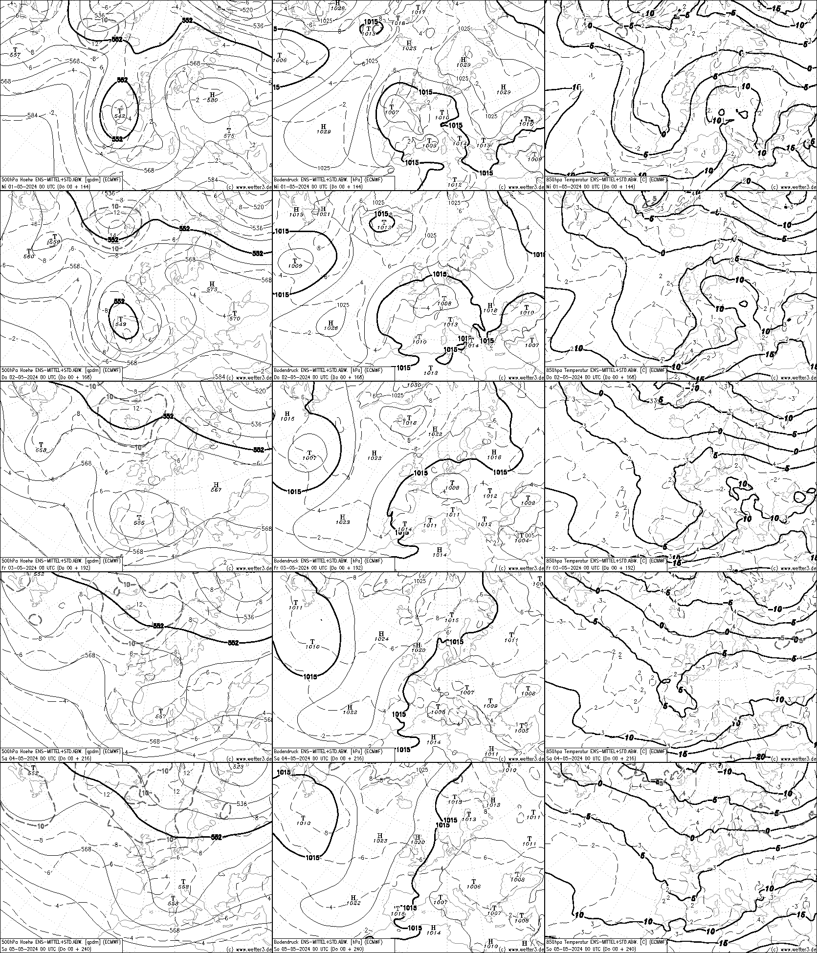
9 hours ago, johnholmes said:
In spite of the fairly solid pattern of meridional flow the 500 mb charts show, I posted earlier this link to the ECMWF output does not
http://www2.wetter3.de/Fax/00_ECMWF_ENS_p0_500hPa+144_240.gif
So which will be nearer the actual weather pattern in 6+ days time?
I have to say I do not know. I cannot recall seeing the anomaly charts so consistently showing a meridional flow without the weather following what they suggest. The ECMWF output is something that has only recently become available, so I have no idea how reliable it is. I do have to say though that I am beginning to wonder if it is not doing better, at the moment, than the anomaly charts?
See for yourselves, the anomaly charts were posted earlier but I'll drop them in here for an easier comparison
ECMWF/GFS DAY 8-10 MEAN 500MB HEIGHT COMPARISON
WWW.METEO.PSU.EDU Climate Prediction Center - 6-10 Day 500mb Outlook
WWW.CPC.NCEP.NOAA.GOVThe 8-14 NOAA carries on with the meridional flow and it shows a pattern in the far west that one would expect to support the pattern in the UK area.
After the cut & thrust of winter is over, it would be great if you were able to do an educational post regarding how to interpret the newly available ECMWF charts to which you refer in the attached post.
-
2 minutes ago, feb1991blizzard said:
Is there a correlation between charts with a low amount of isobars and low verification stats?
Not sure on that. But the col (area with no isobars) is unusually large. It is even more unusual when you see the tightness of the isobars throughout the remainder of the chart. Normally cols are larger in slack pressure gradient scenarios which this chart is not.
-
1
-
-
1 hour ago, MJB said:
So close
Some many conflicting signals all trying to impose themselves at the same time - so charts look unrealistic. Just look at that area without any isobars - stretches from N Spain to just south of Iceland and from the Isle of Man to about 500 miles of west coast of Ireland. Will never happen in reality
-
1
-
-
2 hours ago, mushymanrob said:
Yep, im now off the long cold bandwagon... theres no getting around what the charts are predicting and now the anomaly charts are showing ridging to our near southwest, its game over *for this spell* , It must be said that the GFS picked up on this before the anomalies did.... a rare occurrance.
I know you concentrate on the NOAA anomolies charts, but do you know if the EC / GPS version pick up on this before the GPS model runs?
-
30 minutes ago, IDO said:
I do not make no presumptions as to the trop and the effect from the strat, as this year it seems the trop is driving the strat. If there is a qtr then the models will start showing it, but atm I see no conclusive proof that something is afoot. This is course the gfs and we will see how it handles the SSWE assuming that it is a clean predictable coupling.
Just trying to learn, a few questions if I may:-
Has the trop been uncoupled from the strat so far this year, or has the trop been leading the strat?
If the stat is not leading the trop at time the time of SSW occurence, can the trop lead the response on this?
TIA
-
32 minutes ago, Paul_1978 said:
The ECM doesn't even get anything remotely looking like a reverse flow until T+240, and also nothing to write home about.
I am mystified by this also - i acknowledge that many are looking for a cold / snowy outcome for our neck of the woods, but what i am perplexed by is that there will be much less high latitude blocking anywhere in the northern hemisphere @240 hrs compared to what we have seen over the last week.
-
2
-
-
2 hours ago, weathercold said:
UKMO/ECM have led the the way here, never in doubt when both singing from the same page.
Not so sure ref UKMO, it is very much a short range model out to 144hrs. Weather predictions up to 120hrs are very accurate nowadays (except for a few notable very complicated scenarios like the present), and the UKMO 144 hrs this season have been very hit & miss.
-
56 minutes ago, Nick F said:
Can't help but feel the west Russian block keeps preventing or delaying deep cold pools from dropping out of the arctic towards there
Hi, i'm a beginner, so please go gentle. I noticed that there has been a small trough in Moscow area on the charts for days which seems to me to prevent the 1055mb high pressure west of the Urals linking with the 1030mb ridge over Scandi. Could this be delaying a colder regime setting in for us?
-
4
-


.png.3ca5990d737a45864b911225a7cc98fb.png)
Model output discussion - deep cold inbound?
in Forecast Model Discussion
Posted
Getting this evolution nailed down is worse than getting a tooth pulled. You would like to think it will be sorted by Wed 12z or at worst Thur 0z. Hopefully thereafter we will only have to worry about longtivity and who gets the most snow. The current synoptic pattern does remind me of late 70's and early 80s. Maybe not having access to all the data we now have would be a blessing in scenario's like we have now, poring over every chart since the strat warming event.