


Harry444
-
Posts
7 -
Joined
-
Last visited
Content Type
Forums
Blogs
Gallery
Events
Learn About Weather and Meteorology
Community guides
Posts posted by Harry444
-
-
Winter 2010-11 was only below average due to such extreme cold during December, although the rest of the winter was certainly nothing special and February was well above average. Take the period 1st to 27th December out of the equation and winter 2010-11 has a CET of 5.0*C, not the 3.1 that it ended up. All in all, post Xmas, winter 2010-11 can be seen as a typical winter of the mild 1988-2008 period. This plainly describes that winter 2010-11 was purely an example of a winter starting with an extreme cold spell only to deteriorate into nothing, and the rest of the winter was not special - it isn't an example of a winter being cold overall when the post Xmas part of the winter delivered next to nothing. For a winter being cold overall, 2009-10 was, and winter 2008-09 was reasonable at least up to mid Feb.
Yepp, well said. 2008-2009 was my favorite winter because here in the north west of England we got a very cold spell at the very start of December too. And also I suppose when you say 'up until Mid Feb', there was only two weeks of Winter in theory left.
-
Last year Septembers CFS models were alright, Octobers were not as good but more on the inaccurate side but Novembers were spot on. I don't really like to consider the models being useful (judging from last winter) though, as surely a 6 month forecast doesn't have to be correct only the months before the Winter starts (November?)
As for the August models for 2010-2011, they were also alright but a bit on the downside to an extent that they forecast November well below and December average, so not too much inaccuracy.
July was useless, but that was very very very very long before the Winter, so not too much complaining there

-
Are we in a virtually identical state to the lead up of the winter of 2008-2009??
For those of you who don't know, 2008-2009 was the first of the real cold winters we have seen recently, snow fell in London on the last few days of October I believe, the first week or so of December saw a real cold spell in Northern England especially the Pennines (29th November to 5th December)
January was another cold and pretty snowy month in the usual locations; Scotland and Northern England; where about 5 days where snowy,
Then of course there was February where the snow and cold was much more widespread and heavy.
Anyway, talking of that Winter, for those relying on the CFS models, they messed up 2008-2009 big time.
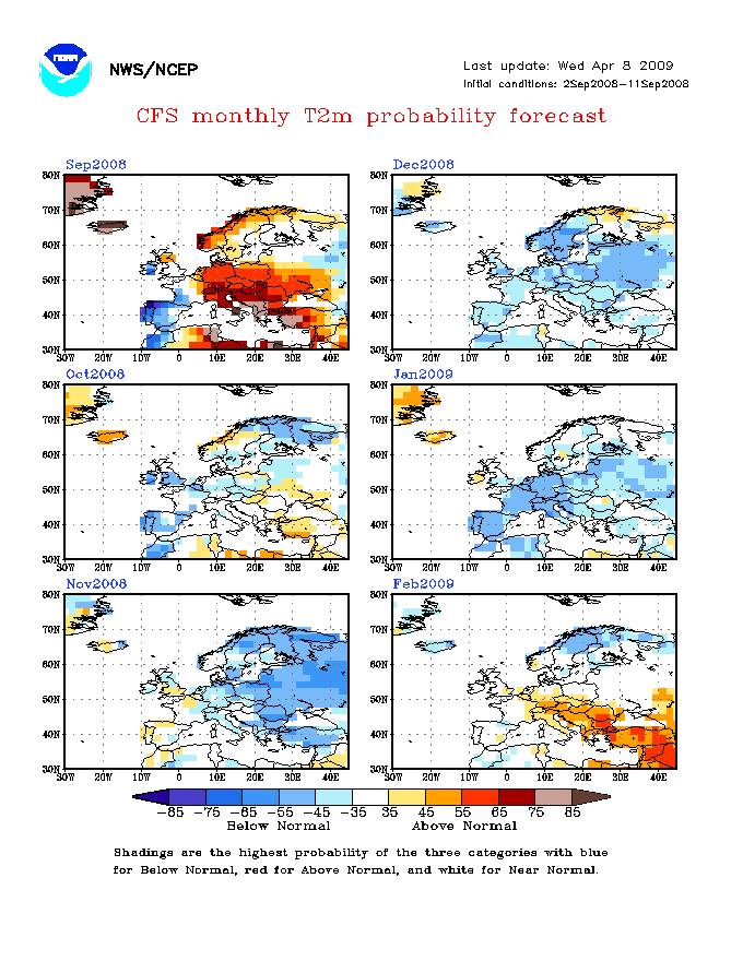
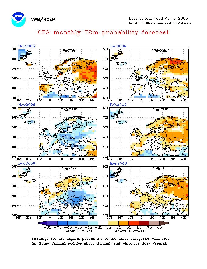
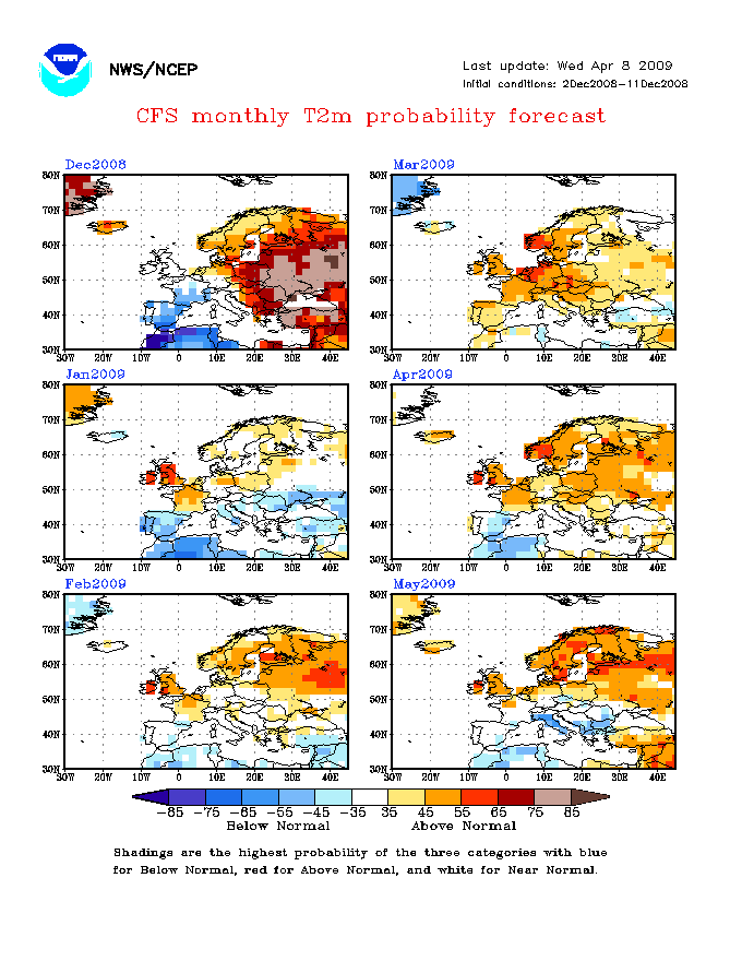
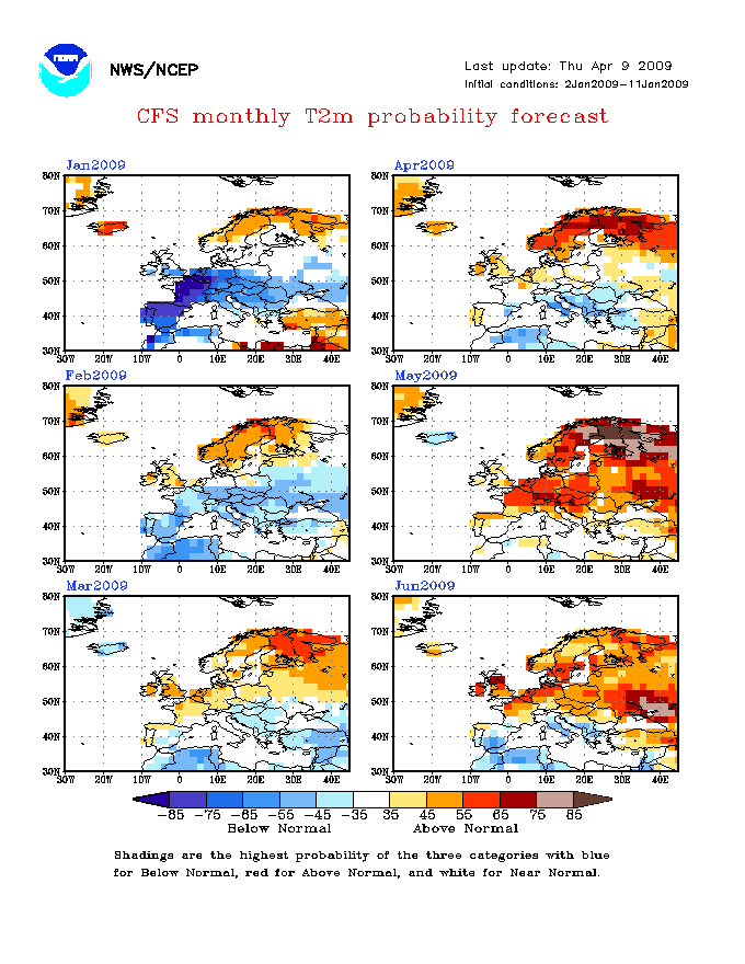
Here is the models as of September 2008
http://www.cpc.ncep.noaa.gov/products/people/wwang/cfs_fcst_history/200809/images/euT2mProbMon.gif
^ alright I suppose except for the average forecast February
http://www.cpc.ncep.noaa.gov/products/people/wwang/cfs_fcst_history/200810/images/euT2mProbMon.gif
^ Models in October 2008, even more incorrect
http://www.cpc.ncep.noaa.gov/products/people/wwang/cfs_fcst_history/200811/images/euT2mProbMon.gif
^ November models, one month away from the first cold spell in December, what are the models playing at?
http://www.cpc.ncep.noaa.gov/products/people/wwang/cfs_fcst_history/200812/images/euT2mProbMon.gif
^ models are taking the mick now!
http://www.cpc.ncep.noaa.gov/products/people/wwang/cfs_fcst_history/200901/images/euT2mProbMon.gif
^ January a touch better but February is just totally wrong!
http://www.cpc.ncep.noaa.gov/products/people/wwang/cfs_fcst_history/200902/images/euT2mProbMon.gif
^ All very correct, but its too late now!
So, if ever your planning on using the rather long range CFS models, always wait till a few weeks before hand, after all the independent forecasters have issued their thoughts.
All very incorrect
-
High pressure will become the main feature this winter keeping it drier than normal, not saying storms won't arrive because they most likely will at times, also not saying we won't get substancial snow fall's from time to time but these will most likely only last a week max for most unlike 2010 when it was a month long freeze.
Yes, so why will it only last for a week?
Are you implying in any way falls could be spread throughout all three winter months like 2008-2009?
Think of it this way, not too sure of the exact averages but lets say the average days of rainfall in January (which at the moment I think we can say is predicted cold this winter so far) is 16, then a high pressure dominated cold month would mean 9 or 10 days would be precipitation days, as well as the cold of course.
I understand what you said, but a week's worth of snow would just be too low from what we have seen in other forecasts so far.
Not too sure how you could be so confident about high pressure; I mean temperatures yes okay but high and low pressure is hard to forecast.
-
Gavin D, why do you actually think we are heading for a mild Winter?
-
Well, here in Greater Manchester, we had some very harsh snowfalls in December 2008 (on the 1st and 3rd), then we had a pretty good light covering on New years,
then we had a moderate covering on something like mid January (somewhere between 10th and 15th I think, which caused traffic chaos in the afternoon) then the snow from that spell remained until it finally thawed on the 25th (apart from what I think snow patches remained on the Southern Pennine Hills nearby from the December spell), then of course we had All the February snowfall. Wouldn't be surprised odd snow patch on the hills survived the first cold of the winter in December all the way to the final thaw in early March.
From my point of view hear in the North West anyway, 2008/2009 was the best out of this recent cold winter cycle, due to its cold consistency.
2009/10 might have been a little more severe, the December 2009 cold spell was equal to February, and the January 2010 spell was even worse, But then of course we had a very mild february ...
2010/2011 was pretty similar to 2009/10, perhaps a bit calmer.

Winter 2011/2012
in Spring Weather Discussion
Posted
Really hating your thinking at the moment. I see absolutely no direct mention of 'Mild' in that forecast, yet you say at the beginning 'PWS are going for Mild'. Doesn't make sense, your twisting their words