


moffatross
-
Posts
350 -
Joined
-
Last visited
-
Days Won
1
Content Type
Forums
Blogs
Gallery
Events
Learn About Weather and Meteorology
Community guides
Posts posted by moffatross
-
-
1 hour ago, SW Saltire said:
Don’t have a rainfall gauge but if I did the totals would be very sexy. Rain just has not stopped
The SEPA river level gauge a mile or two downstream from Moffat had the Upper Annan at 97% of its highest ever recorded level (December 2015) a wee while ago. Textbook orographic enhancement throughout this rainfall event, with the rain radar here on netweather looking exactly like a topographic map !
-
 7
7
-
-
18 minutes ago, Ravelin said:
I'm fairly sure that XC Weather is based on the raw GFS, not the ECM.
Since all the models are changing so significantly and frequently as far as snow is concerned then they should all be taken with a pinch of salt.
Yes it does. The nearest (and perhaps only freely available) equivalent to XC Weather that uses the ECM instead of GFS is yr.no e.g.
 Yr - Moffat - Weather forecast
WWW.YR.NOTodays weather forecast, by the hour and long term. See the forecast as a table or graph.
Yr - Moffat - Weather forecast
WWW.YR.NOTodays weather forecast, by the hour and long term. See the forecast as a table or graph.-
5
-
-
- Popular Post
- Popular Post
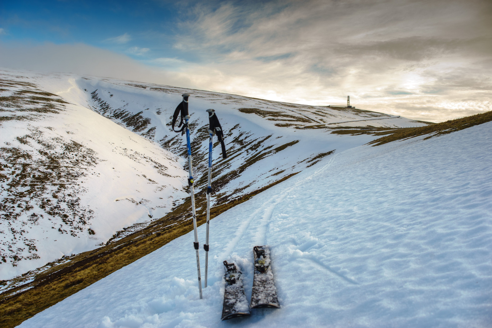
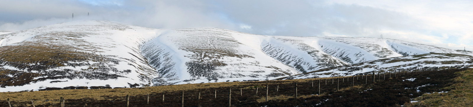
I enjoyed a few hours on skis up in the hills above Moffat today. Snow cover is pretty good on some aspects, with some enormous drifts, but it's stripped and/or icy on others.
Admiring the drumlins in the glacial landscape of the Upper Talla Glen ...
High above Loch Skeen ...
-
12
-
- Popular Post
- Popular Post
15 minutes ago, Hairy Celt said:Turned out to be a cracking sunny day with just a little high cloud. Very pleasant to be out in as there's little to no wind.
It's cloudy now and intermittently pishing down with cold rain in Moffat, but in a break about an hour ago, the warmth from the sunlight falling on my hands, neck and face reminded me that Spring is just around the corner.
-
12
-
1 hour ago, Steve Murr said:
Im not sure if im imagining it but im sure at the top of the hill theres a little railway you can get on-? It was about 8-9 years ago
There's a wee dead-end road in Leadhills that goes up to the railway line that runs to Wanlockhead. It's the last remaining operational part of a narrow gauge line that carried the ores away, and the route of the track can be seen running alongside the road all the way down to Elvanfoot where it linked with a siding at what's now the West Coast mainline.
The off grid, solar storage hill camera I'm referring to is the one on Lowther Hill itself at around 720 m ASL, one which we installed a couple of years earlier than the Hopetoun Arms one, pretty much straight after we built the ski tow engine hut.
-
5
-
-
16 hours ago, Steve Murr said:
I stayed there with wifey a fair few years ago so always check in on the webcam.
Snowing this eve
It's a great pub and Rab & Rachel are lovely. On the camera, this one is hardwired to the internet and powered over ethernet but the one on the hill is solar powered and uses an antenna pointed at Sanquhar so as to overcome the RF interference from the radar dome. I really can't imagine a location at which winterhighland's Alan couldn't get a webcam working one way or another. He's a genius with them
-
4
-
-
- Popular Post
- Popular Post
1 hour ago, shuggee said:2.8/2°C here at the moment. Precipitation a couple of hours away. Can't be late for work in the morning.....
It's already turned to snow in the higher roads further west.
I'll always have a soft spot for this webcam Alan from winterhighland did all the networking but I drilled the holes through the walls of the hotel, ran the cabling and fitted the camera to just under the upstairs eaves.
-
13
-
- Popular Post
- Popular Post
The Met Office have just issued a yellow weather warning for snow above 200 m ASL across a large part of the upland Highlands area and a good chunk of the Southern Uplands. The Euro 4 is modelling impressive new snow accumulations over the mountains between now and tomorrow night.
-
10
-
13 minutes ago, shuggee said:
Went to Tesco in Peebles on Saturday and stocked-up big time! Local shop in Broughton selling bags of oak to burn though - always worth a visit as it's hot hot hot.
Dewpoint has gone negative for the first time during this 36 hour spell. Nice.
I love that Tesco in Peebles. I used to do some work in there and although it's the smallest Tesco you can ever imagine, it's a great shop and the staff and management are really nice people. I did a photography job at the newly opened Broughton stores last year too, and was v. impressed by the collective village initiative. It's an excellent shop now, and has a better selection of goodies than it ever had before.
-
3
-
-
29 minutes ago, shuggee said:
Ooooo. I appear to be in the middle of that lovely amber colour.
I was thinking of you when I saw that area map and that you might be wise to nip up to Broughton for your 'snowed in' rations. The A701 can get a wee bit 'drifty' !
-
4
-
-
4 minutes ago, Ruzzi said:
Yep, here it is
There was a lot of rain last night in Moffat, but since 6 am, each passing shower has been getting wintrier. It's settling readily just now.
-
3
-
-
Just now, Spindrift2017 said:
I think it’s the temperature as read by a thermometer with wet cloth wrapped on the bulb, and it therefore indicates the lowest temperature the air at any given time can potentially reach through evaporative cooling.
But someone who really knows what they are talking about can correct or confirm this!
I'm no expert, but that's my understanding of it too. When you see snow falling on puddles or wet grass and it kinda does nothing for ages but then all of a sudden everything goes white, that's the point at which wet bulb temperatures are approached freezing. Locally, the ground level air mass can be cooled enough by heavy precipitation for wet bulb temperatures to change, but in showery, windy, mobile conditions, wet bulbs are mostly determined by the overall air mass and therefore those wet bulb temperatures are harder to shift downwards.
-
9
-
-
- Popular Post
- Popular Post
Looking at the suite of model output, tomorrow's the day when wet bulb temperatures become conducive to snow accumulating. They're at their maximum overnight tonight, particularly through the Central Belt, so anything that accumulates today will met away, but as of 6 am, it's looking good everywhere.
-
10
-
3 minutes ago, Ross90 said:
Tonight has been a bit of a let down so far considering 5-6pm was forecast as the period of strongest winds, 50 - 55mph max in the lower parts of Strathclyde.
Aye, and I'm hoping we're off the hook for the time being too, but maybe a wee bit too early. The Met Office forecast has the wind peaking around 6 pm, but so far it's pretty standard wind and rain stuff for Moffat i.e. it's like the fire brigade are outside our hoose and are hosing the windows, but not like they're trying to remove the roof at the same time!!
-
5
-
-
32 minutes ago, Stormeh said:
Amber warning for rain has just been issued for SW Scotland, Lothian Borders.
Interesting. That's a very localised area in the amber warning zone, east of Eskdalemuir and towards Kielder. It's the leeward side of the Southern Uplands that in my experience, gets heavy rain much less frequently than we do on my side of the hills but those Tweeddale towns can be prone to flooding when it does happen.
Edit - Tweeddale, not Tweedsdale. D'oh !!
-
5
-
-
Pretty much all of CalMac's weekend sailings have been cancelled, and it's not looking too promising into next week either. Mind you, there are worse places to be stranded than Barra, North Uist or Lewis
Service status & info | Caledonian MacBrayne
WWW.CALMAC.CO.UK-
6
-
-
1 hour ago, Hairy Celt said:
@Kirkcaldy Weather - you can't polish a turd...
'...classic Scottish countryside scene of wild deer, grouse and snow, February 2020. #fortheloveofcountrysports...'
I mean, a hill degraded by too many deer is still a hill degraded by too many deer even when covered in snow.
It looks as much to me like a land degraded by historical deforestation and contemporary grouse shooting as one degraded by deer.
-
3
-
-
2 hours ago, Norrance said:
-7.2C here this morning was my lowest this Winter. A beautiful sunny morning but still cold at -4C in the garden.
Did anyone see the Northern Lights last night? Here are a couple of pics from Aberfeldy last night, courtesy of Iain Struthers. He said he couldn’t take any more as his hands were starting to freeze.
I was gutted, scooting about in the van with my camera & tripod finding looking for some clear sky but everywhere within 10-15 miles of Moffat was cloudy when the aurora was peaking. My fantasy aurora for photography is for a clear sky when there's snow on the ground, a frozen loch in the foreground, and just enough moonlight to illuminate the landscape of mountains as the aurora dances behind them
-
1
-
-
1 hour ago, Ruzzi said:
MetO early warning for Monday issued
Looks like they're going for an inland with respectable altitude type event.
Looking at all the various MO and the associated DPs and 850s, none of which support snow much below the tops of the hills, it's hard to see their reasoning behind heavy snow at 150m ASL.
-
1
-
-
- Popular Post
- Popular Post
"UK on amber alert as heavy snow forecast"
https://www.bbc.co.uk/news/uk-47071846
Sorry for the semi-political rant, but that's a headline emblematic of the new BBC that I've come to expect. Its standard of journalism (and bias) has become exactly that of Daily Mail. An area which includes a part of South Wales and a part of Western England is issued an amber alert for snow, and its headline reads 'UK on amber alert'. Yeah, the UK is on amber alert, but not for the weather.
-
13
-
For all the told-you-so'ing, hair-pulling and toys thrown out of prams that I can imagine might be going on in weather forum model threads just now (don't know if it's true, but that's my guess), the season has been OK so far in Scotland. Limited snow for sure, but no house-wrecking storms, plenty of dry days with a bit more sunshine than usual, very few spells of incessant pishing down rain, and now that the evenings are just starting to get noticeably later, the promise of Spring just around the corner without the legacy of expensive autumn/winter repair bills. Silver linings and all that
-
3
-
-
3 minutes ago, Zenarcher said:
The snow has arrived here on Barra today it's still mainly on the hills with a light dusting at lowe levels. These are photos I took this afternoon. In the last hour, it's started snowing again.
Awesome ! Last time I was in Castlebay was a week before the indy ref while on a cycle tour. Heaval is a great wee hill.
-
The GB & NI ICON 5 day accumulated precipitation chart looks as if someone has selected the 'invert weather' option. Can we have this in the summer please ?
-
1
-
-
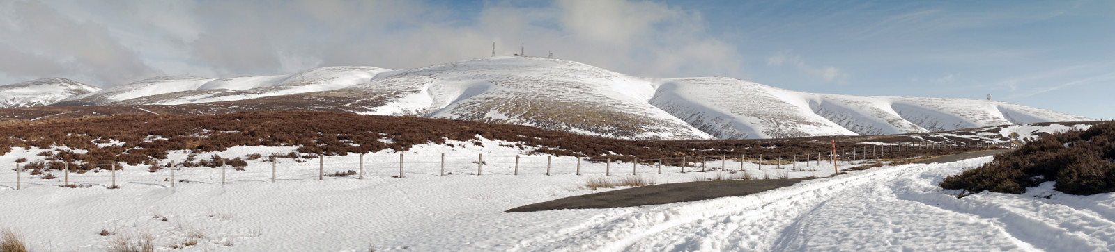
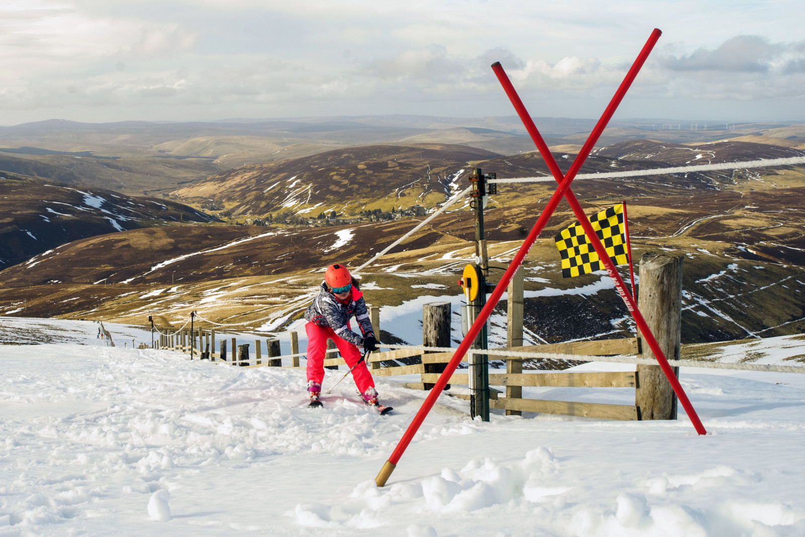
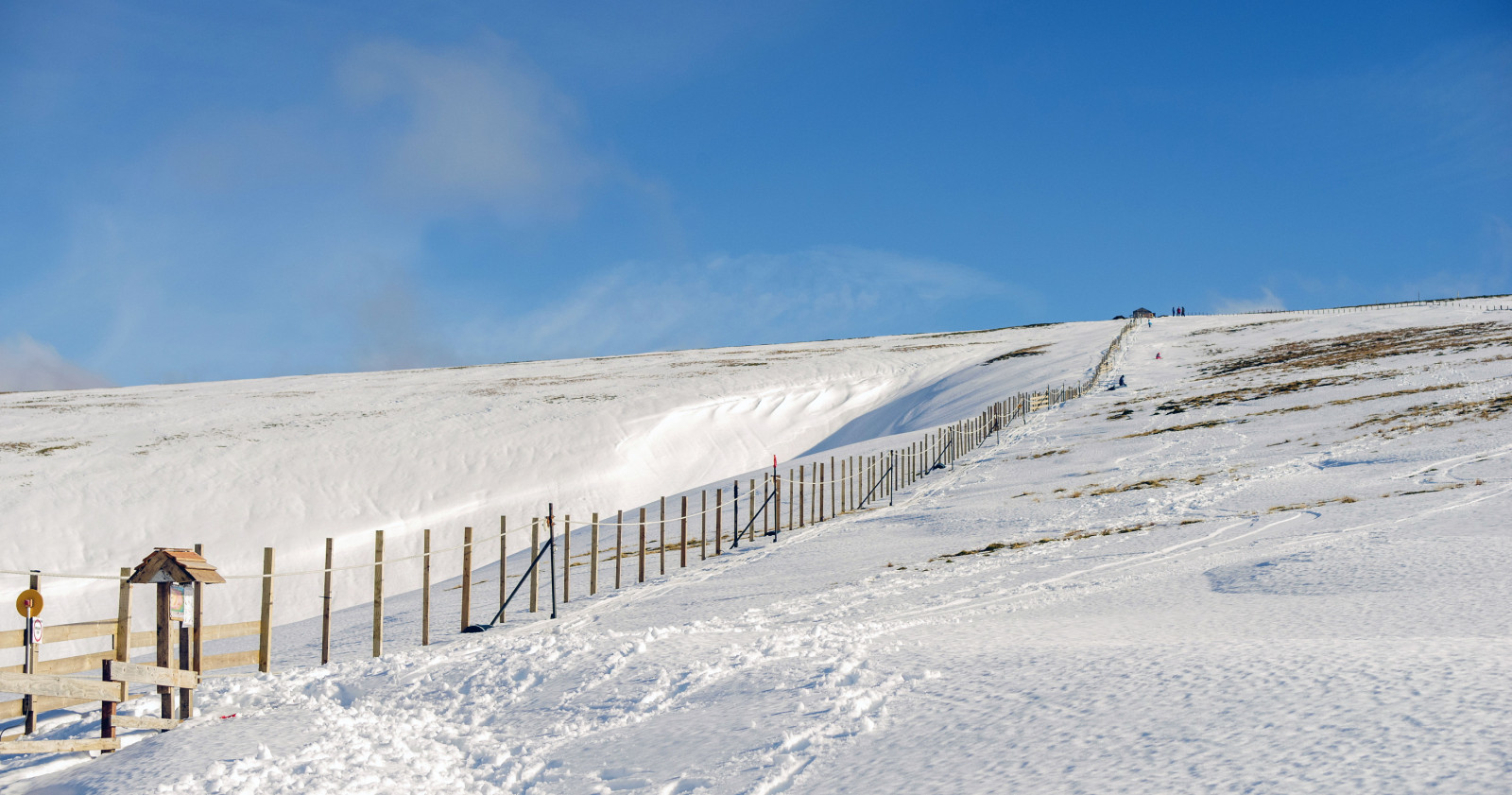
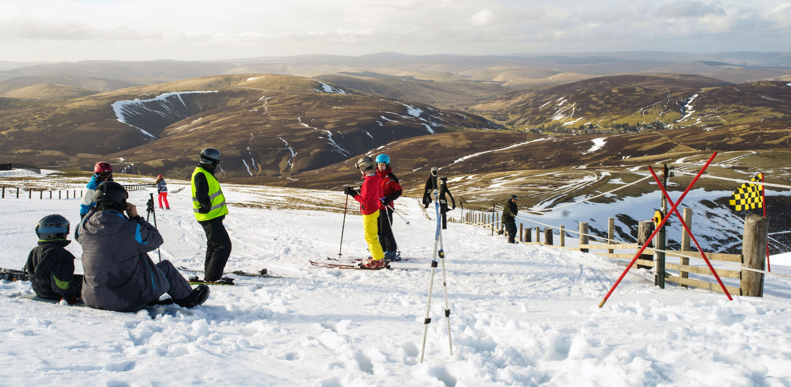
- Popular Post
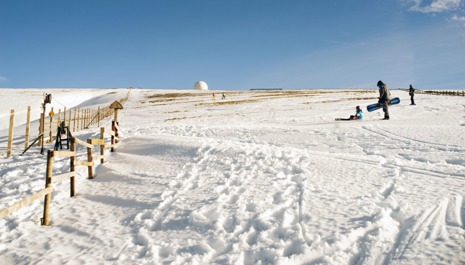
On Lowther Hill this afternoon. Proper grass roots club skiing in the South of Scotland :
http://rossofmoffat.com/albums/lowther-hills-ski-club/
On the way up ...
Top of Lowther rope tow ...
Bottom of Lowther rope tow ...
Skiers on Lowther Hill ...
Good coverage of fast, sugary spring snow ...
A mile long run from the top ...
Looking back to the hills as the light fades ...
-
15


Scotland Weather discussion
in Scottish Weather Discussion
Posted
The River Annan at Brydekirk is still rising, and is only 6 cm short of its height record from November 2009.
SEPA Water Levels - Annan @ Brydekirk