
The recent warm spell in the UK is ending with cooler temperatures, showers, and a chance of snow on high ground in northern areas. Meanwhile, mainland Europe enjoys continued warmth.
The warm spell of weather is set to continue today in East Anglia and southeast England, but it will generally be cloudy until the warm air clears away southeastwards. Over the next few days, Britain can expect a change to much cooler weather with sunshine, showers, and northwesterly winds. Some earlier model runs had suggested the possibility of lowland snow in the north, but as often happens in these situations, the intensity of the cold air outbreak has been toned down as we have got nearer the time, so it currently looks probable that showers on low ground will be of rain and hail, with sleet and snow chiefly on high ground, and mainly in the north. Nonetheless, it will be much cooler than we have recently been used to.
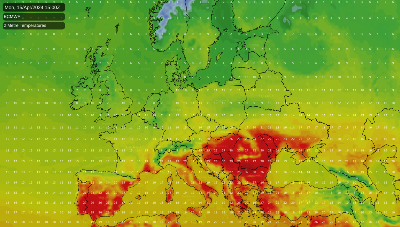
Meanwhile, for the second weekend in succession, it is set to be unusually warm for the time of year in other areas of central and western Europe, with East Anglia and the southeast currently lying on the edge of this warm pool of air. Temperatures across most of central Europe will reach around 21-23°C today, while in France, most places will reach around 25°C, and in parts of south-western France, it will reach 30°C. Similar temperatures are expected in many areas of central and western Europe tomorrow. However, it will turn cooler from the north, and by Monday, most of Europe, as well as Britain, will have cooled down considerably.
Today will start wet in most of Wales and through Lancashire and Yorkshire, and this rain will spread slowly eastwards through the day but tend to peter out as it moves east, so East Anglia and the southeast will generally remain dry. A band of showery rain, which may be accompanied by thunder locally, will move eastwards through Scotland and northern England, followed by much brighter weather with showers, and the showers will turn wintry in the Scottish Highlands. It will also become windy, especially in northern Scotland.
The recent warm weather will hold on for another day in East Anglia and southeast England, where, despite extensive cloud cover, temperatures will reach 20 or 21°C, especially near North Sea coasts. Highs of 13 to 15°C will be typical in most other regions, but it will turn much cooler in western Scotland and northern Northern Ireland, where highs of around 10°C will be typical.
A ridge of high pressure will result in a dry and clear night for most. Showers will die back to west-facing coasts, and most places will see a minimum temperature of between 3 and 6°C.
On Sunday, much of the country will start dry and sunny. Still, it will cloud over from the west, and showers, which will merge at times into longer spells of rain, particularly in western Scotland, will spread from the west, affecting most of Scotland, Northern Ireland and, north-west England and north Wales during the afternoon. Sheltered eastern areas will stay dry and hold on to some sunshine, particularly in north-east England. There will be hail and/or thunder locally in western regions associated with the showers. Temperatures will reach 10-11°C in most parts of Scotland and Northern Ireland and 13-15°C over the majority of England and Wales. It will again become windy after a relatively calm start to the day.
The chilly northwesterlies will set in on Monday, bringing a mix of sunshine and showers to all parts of the UK and cooler temperatures generally. It will reach around 11 or 12°C in southern England, but other areas can generally expect maximum temperatures between 8 and 10°C. The showers will mostly be of rain or hail, but sleet and snow will fall on high ground from north Wales and the Midlands northwards, and some sleet may penetrate to low levels in the heavier showers in Scotland and Northern Ireland.
Tuesday will see the winds veer northerly, and showers will generally be fewer than on Monday, but some places will still see a fair number of showers. On Wednesday, showers will become mainly confined to eastern England, with many other areas becoming dry, although some cloud and rain will spread into the west of Scotland.
It should be noted that this northerly/northwesterly outbreak will not be unusually cold for mid-April. We had widespread sleet and snow showers on low ground in late April 2016 and 2017 and a snow event in northeast Scotland in late April 2015. Temperatures will be a few degrees down on the seasonal norm. Still, the upcoming cool spell will not be as unusual as some of the recent warmth in eastern England or other areas of central and western Europe.


.png?w=1200)


