March has started cool after a very mild February. This pattern holds until Tuesday, and then things get uncertain with some models bringing milder air from the southwest; others aren't so keen, though.
Regular easterly winds have caused March to begin relatively cool. Although temperatures have been close to the long-term average, after an unusually mild February, it has felt cooler than many of us have become accustomed to.
This pattern is set to persist until Tuesday, but there is considerable uncertainty from Wednesday next week onwards. The Met Office and GFS medium-range forecast models predict a warm, changeable south-to-south-westerly weather pattern, which would bring maximum temperatures of 12 to 14°C widely in eastern and southern England during brighter spells. However, in this scenario, we will frequently see bands of cloud and rain pushing in from the south-west.
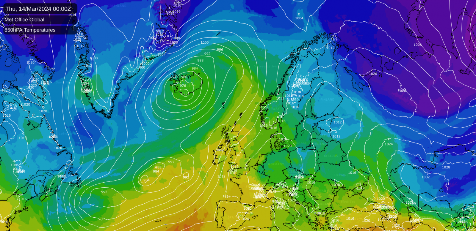
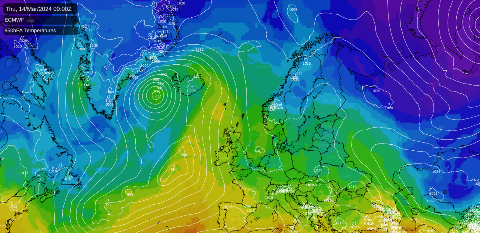
The ECMWF model, on the other hand, maintains the Scandinavian blocking high, keeping the weather relatively cold and dry in Scotland and eastern England while allowing wetter weather to affect the south and west of Britain at times.
On balance, it seems likely that we may move into that warmer, changeable pattern by next weekend, and it may only be temporary, as there is a continued signal for high pressure to the north of Britain during late March, which will leave us relatively vulnerable to northerly or easterly winds.
Saturday will be a predominantly cloudy day for most. Still, there will be some sunny spells in parts of western Scotland and Northern Ireland and a spell of dry sunny weather in the east of England, mainly affecting East Anglia. During the rest of the day, the sunny weather in north-western Britain will become mostly confined to north-west Scotland, while the sunshine in East Anglia and around Cambridgeshire will extend into much of the Midlands, Lincolnshire and north-west England for much of the day. Some light rain will push northwards through the north of England to around the Scottish border, while light showers will develop in eastern Scotland. Cloud and rain will spread into Northern Ireland, much of Wales, and south-west England.
In parts of eastern England, especially around Cambridgeshire, temperatures will reach around 12°C, but elsewhere highs of 7 to 9°C will be typical, and they may get no higher than around 6°C in parts of eastern Scotland and the far north-east of England.
Sunday will be a generally cloudy day with outbreaks of rain pushing from south-west to north-east. There will be some dry, sunny weather in coastal north-west Scotland. During late afternoon and evening, some brighter, showery weather will push into south Wales and southern, especially south-western, England. With some colder easterlies pushing in, temperatures will only reach around 6°C in much of Scotland and north-east England, but when it brightens up in the southwest, highs of around 11 or 12°C are expected. In most other regions, temperatures will again reach between 7 and 9°C. The colder air in Scotland will result in snow falling extensively on high ground, but still with rain at low levels.
A ridge of high pressure will bring generally dry but rather cloudy weather on Monday and Tuesday. However, there will be some scattered showers in the east on Monday, these wintry on high ground, and some sunshine for sheltered western areas, particularly in western Scotland. With fairly cold easterly winds blowing, it will be on the cool side for mid-March, with temperatures in northern and eastern Britain only reaching around 6 or 7°C. Still, sheltered western areas, particularly the south-west, may reach around 10°C.
From Wednesday onwards, we will see warmer, changeable weather try to push in from the south-west, with the uncertainty mentioned earlier relating to how strongly the Scandinavian blocking high holds and slows the rate at which this warmer air makes it into northern and eastern Britain. It is likely to be mainly dry for most on Wednesday and Thursday, potentially with some sunshine coming through, with more unsettled conditions pushing in late on Thursday and into Friday. The odds favour the warmer air moving into most regions by next weekend.