More heavy rain moves into southern England and south Wales to end the weekend with flooding possible. Further north there'll be sunny spells and scattered showers. Some rain and showers will then linger, particularly in eastern regions on Monday.
At this time of year, there is a tendency for low-pressure systems to take a more southerly track as they approach Britain, pushing our traditional Atlantic westerlies into lower latitudes. An approaching depression is doing precisely that today, moving into the Southwest approaches before ending up across northern France tomorrow.
Raw east or northeast winds on the northern flank of these lows can result in wintry weather across the UK, but on this occasion, it will be rain rather than snow. However, there is a forecasting headache as to how far north across southern parts the rain will come before the depression moves away onto the nearby continent.
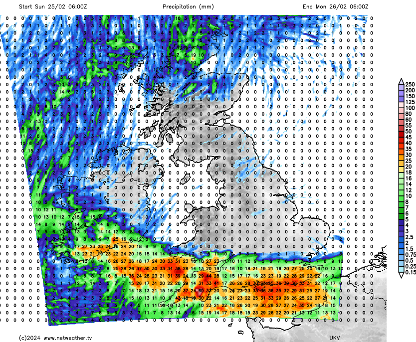
After an early frost and patchy fog, the northern half of the country will be fine with sunny spells. Although mainly dry, the odd shower may develop, but these will be mostly reserved for the north of Scotland. The exception to the fine weather will be the south, where bursts of rain already over South Wales and the southwest will probably get as far east as Sussex by dusk. The rain, heavy at times, will affect places mostly south of the M4, giving 25 to 35 mm in places, prompting a yellow Met Office warning of rain for this area. Already saturated ground will mean flooding will become an issue again, with cloud on the northern edge of the rain probably also producing a few showers across the South Midlands and Home Counties.
For most, there'll be light breezes, but across southern and some central parts, an east or northeast wind will "spring up," making it feel quite cold. Northern Ireland will also see a chilly, northerly wind later. Still, despite this, maximum temperatures of 6°C in the far north and 7°C to 10°C elsewhere will be close to normal for late February.
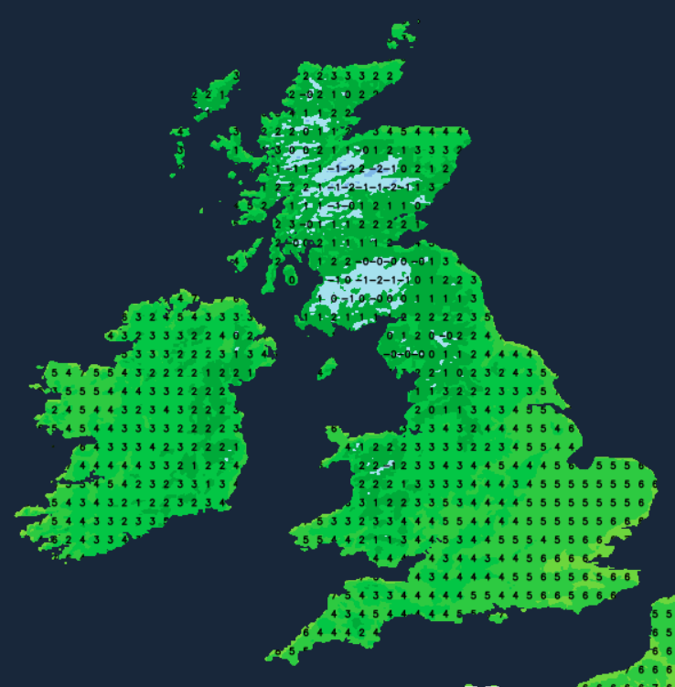
The rain reaches the southeast by evening and continues overnight, with the remainder of the south seeing a clearance moving in from the west. A cold and gusty northeast or northerly wind will develop that'll bring scattered showers to eastern coastal counties of England and maybe to north-facing coasts of Northern Ireland, while the far north continues to see a few showers. Elsewhere, it continues mainly dry, with the best of the cloud breaks in the west and over Scotland. Here, expect another frost with the lowest temperatures zero to -2°C, but across the east and south, despite feeling raw, the wind will help prevent a frost with 2°C to 5°C nearer the mark here.
The Suffolk coast and Kent see further rain into the new working week, but this should eventually move away. This will leave the southeast and eastern coastal counties with just a few showers in a cold and blustery north or northeast wind that'll give strong, even gale-force gusts for a while before decreasing towards dusk. But for much of the country, there'll be some sunshine, with the north and west, in particular, feeling quite pleasant into the afternoon in lighter breezes under a ridge of high pressure. Despite a frost and a few fog patches here at first and the chilly wind further east and south, temperatures should reach 6°C to 10°C again.
Any showers still left move away from the South East, leaving most parts fine and dry. There'll be clear spells, and with light winds, a frost and patchy fog will develop as temperatures fall to -1 to -3C, but perhaps as low as -5 or -6C in the coldest spots. The exception will be Scotland where a freshening South West wind will be bringing milder air but also some rain to the North and West later.
And as we come to the end of meteorological winter, the outlook remains unsettled and windy at times, but it'll continue to be mostly mild into the new month.