
It's not an ideal forecast for the Coronation Bank Holiday weekend. There is rain, a good deal of cloud and the threat of thundery showers, but hopefully breaks with brighter skies in between.
The next May Bank Holiday weekend is coming up, and it includes the Coronation of King Charles III. The forecast looks unsettled and includes; occasional warm sunshine, frontal rain bands, then thundery downpours, some murky low cloud and winds veering to a south-westerly flow.
With this uncertainty, it is not worth pinning your hopes on the hourly output from your local forecast just yet. Those symbols will shift and change. However, there are some themes emerging:
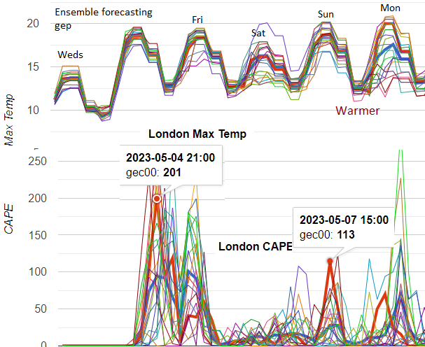
Milder air will be across the UK on Friday and Saturday, with warmth showing itself from northern France across the Channel to SE Britain on Saturday evening. For London, temperatures will be around 17 to 21C. Most of the UK will be in the mid to high teens this weekend, perhaps tipping into the low 20sC in sheltered sunshine.
This time round does look warmer than the past four Coronations. Edward VII in August 1902 - 16C George V in June 1911 - 17C both hardly had any rain. George VI in May 1937 was a cool and wet day at 14.2C as a maximum temperature, and for Elizabeth II in June 1953, there was also rain and the coolest at only 11.8C.
After a mostly easterly flow in the week, there looks to be a shift to a westerly by Sunday and a south to SW wind on Monday. There is rain in the forecast. Frontal bands and a scattering of showers. Clusters of heavy downpours and the risk of thunderstorms. There looks to be a drier interlude on Friday night and for part of Sunday, but organisers of events will be looking at this feeling disappointed. You could still be lucky and encounter a gap. The models disagree on the timing of rain from the southwest on Saturday morning and so how quickly it reaches London.
Friday starts with a brisk easterly wind over northern Britain ahead of an occluding front. It will feel cold in the far northeast. There could be gales but with brighter skies. This band of rain continues pushing northwards, and the wind veers to a south-westerly behind it with a whole host of showers. Behind the front, the winds will be lighter, but the SW wind becomes moderate over southern Britain.
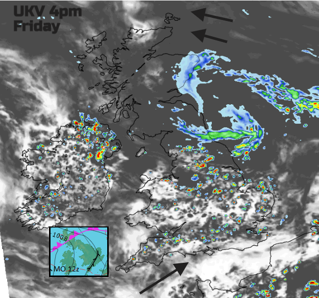 Heavy showers showing over Northern Ireland and central Britain into eastern areas. Friday afternoon
Already a convergence line has been drawn on the Met Office synoptic chart of Friday. There will be this push of air in the SW winds, but also a slightly veered flow along the Bristol Channel across Wales. Where the two meet, there will be uplift and showers. It could mean that along the south coast, there will be fewer showers for a time on Friday. Temperatures of 15 to 18C, but there will be some heavy, thundery showers with the risk of hail.
Friday evening in London currently looks fine and dry with light winds. Any heavy showers should have faded, so for those camping out overnight to get a good view, the first part of the night looks okay. The cloud increases so it won’t be too cold, although there will be some dampness around. There is low confidence around the timing of the incoming frontal rain.
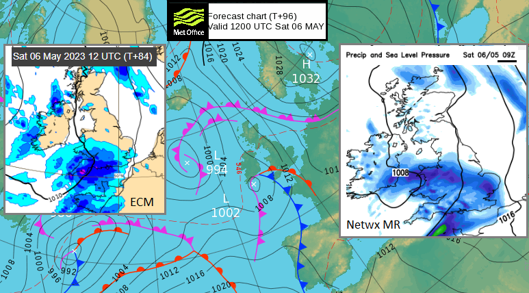
Saturday looks to have another cloudy start with a new low moving in from the southwest. This will bring rain over southern Britain and looks like it will affect the Coronation parade and the spectators. The models vary from rain arriving in London before dawn from the warm front and more from the trailing fronts to the whole system taking its time during Saturday morning. It does look like there will be some rain for London by late Saturday morning in time for the Coronation. Behind the frontal band, there could be lines of hefty showers for southern Britain.
This extra cloud and frontal rain will inhibit any sunny spells and uplift over much of the UK. So, temperatures will be subdued where it is grey and rainy. The airflow is warm, especially later in the day for the southeast. If breaks do appear, it will soon warm up, rather like last weekend.
The frontal bands will still be over Britain on Sunday with a lot of murky cloud, outbreaks of rain and, again, the risk of heavy, thundery showers. It will be eastern areas seeing more of the rain, with a fresher westerly flow picking up. This will affect the temperatures. If the frontal band clears away over the North Sea, eastern areas will lift into the high teens with some sunshine. Showers will develop again over England with the risk of heavy, even thundery downpours. East Anglia and SE England, including London, are highlighted on the Met Office model. The ECM has a better day.
There should be a slight lull later on Sunday before the next frontal system moves in from the Atlantic. This starts as a band of moderate rain with more cloud and blustery SW winds but turns more showery on Monday. It’s not the best picture for a Bank Holiday Monday, but there should be some sheltered, brighter east or north-eastern areas once the front clears. Here temperatures will tip over 20C. Bands of heavier showers will develop and line up, but other areas could miss most of the rain. For those starting the Big Help Out, it’s a mixed picture, and the detail will only develop nearer the time. Keep an eye on the radar, and don’t follow those weather app symbols too closely just yet.
 Some days over the weekend have the potential for thunderstorms once frontal rain bands clear
Friday evening, the heavy daytime showers will fade, leaving a quieter night.
Saturday, the frontal rain continues northwards to Northern Isles. London will be watching the progress of an incoming weather system from the southwest with rain and a lot of cloud. It may manage to swing away and allow a better evening for the southeast. The Met Office model has heavy showers passing through.
Sunday might see a lull before showers break out from the west. It depends on how soon Saturday’s frontal band clears away from eastern Britain.
Sunday night into Monday, a new frontal band of rain from the Atlantic turns showery during Monday. Eastern areas could miss most of the showers and see some warm sunshine.


.jpg?w=350)

