
With a cool north wind to end the week, temperatures will fall and there is the risk of frost in the north. For those queuing in London, it will feel nippy by night.
This week will bring quite a change as the winds swing around to the north and the nights turn chilly. There could even be a touch of frost for rural northern spots. We’re into meteorological autumn now and the evenings seem in a rush to get dark now. However, London saw 27.2C on Monday and the sunshine is still strong.

At the beginning of the week very warm air was forced up through France to southern Britain by a large low pressure off western Iberia. This was ex-hurricane Danielle and that warm plume allowed temperatures in SW France to pass 40C. This was most unusual and could include a new September record for France.
Scandinavia, particularly Finland has had a huge swing in its temperatures. It was exceptionally warm and dry with Finland seeing its fifth warmest summer. Late August saw a daily minimum temperature on the 24th of 20C in Helsinki, the highest on record this late in the summer.
Suddenly, September turned unusually cold. September 8th saw -7.5C at Ylivieska airport and the first week of the month was the coldest for several decades. Lapland even has sleet in the forecast today. And it is this colder Arctic air that will feed around a large low pressure and head southwards. It will modify as it travels over the North Sea but it does bring the change for the second half of this week to the UK.

It is still early for significant north Atlantic temperature contrasts which strengthen the jetstream, but this mid-September cooler air is an early practice against the warmth further south over continental Europe. There was a cut-off meander around the ex-Danielle low with a more zonal flow across the North Atlantic. This will help develop the Scandi Low. A huge buckle and trough appears over Europe by Saturday and the jet engages a new low which develops over eastern Europe at the end of the weekend. It moves north early next week.
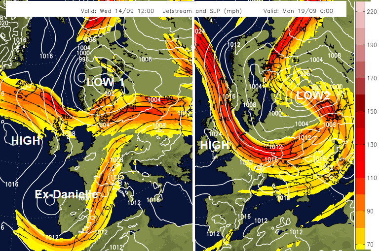
The northern low pressure will bring welcome rain but also blustery, unsettled weather across Scandinavia and the Baltic Sea as the low centre grinds to a halt.
High pressure will be building in from the Atlantic and allowing plenty of fine, settled weather for the UK this weekend. In between that high and the Scandi Low there will be a brisk cool flow from the north.
The midweek rain over southern Britain, and which accompanied the Queen’s coffin from Northolt to Buckingham Palace, is the main cold front. This is clearing away down to the Alps by Thursday night and that same flow of cooler air reaching down through Greece by Sunday.
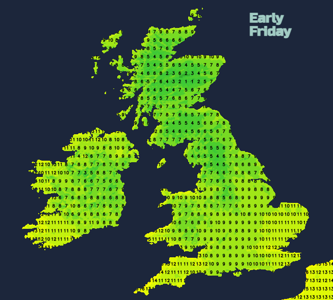
For the UK in this cooler airmass, there will be mist and shallow fog forming where winds are light. A few Highlands glens will see a frost on the grass as the overnight temperatures just before dawn on Thursday. London will feel cooler by Friday, although still with strong sunshine for those standing out in it, the air will feel different and noticeably colder for Friday night, down to 6C in the queue. There will be more of a frost risk for early Friday and particularly early Saturday extending from central/western inland Scotland down into Cumbria, the Pennines and the Yorkshire Dales
As the colder air passes over the relatively warmer waters of the North Sea, the air will become unstable and showers are forecast. These graze eastern England on Friday with the risk of a few heavier downpours, even hail and will also affect the far north of Scotland. The Friday MR charts show a few tiny bits of pink (for Snow), at 6pm on the top of Cairngorm but also at 9am in the showers along the north coast.
First Ground and Air Frost thread in the Netweather community forum


.jpg?w=350)

