Blog looking back at the historic record-breaking heatwave earlier this week. GFS was the first model to pick out 40C being reached by one ensemble member way back on 30th June, before the operational runs started picking up the potential still two weeks out.
Hard to believe still, but it happened, the UK reached 40C for the first time ever in recorded history this week. Even though it’s been well-established global temperatures will continue to rise due to climate change, it was perhaps something we thought we wouldn’t see for a good few years yet. But the weather models, for the first time, started showing 40C or more across parts of England at the beginning of July.
It was in fact the American Global Forecasting System (GFS) weather model that first started showing 40C across southern England on one ensemble member on the 30th June for Friday 15th July, over a fortnight in the future.
Perturbation 3 of the GEFS initialised at 12 UTC on Thursday 30 June 2022, valid 18 UTC Friday 15 July:
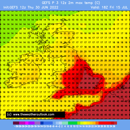 Image courtesy of theweatheroutlook.com
We thought at the time it was a one off given how far out it was and also that it was just one ensemble member. Models can often run the odd wild ensemble that shows an extreme temperature be it hot or cold end of the spectrum, after all, ensembles are run to provide a range of possible outcomes, with clusters of ensembles showing similar outcomes used to build a picture of what happen in the future.
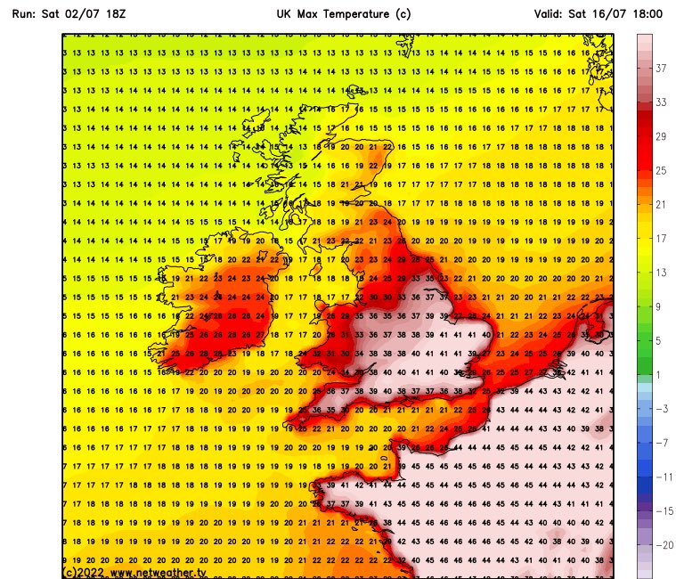
One ensemble run out of 21, with an extreme such as that seemed very unlikely. But the GFS, over the next few days, continued to show more and more ensembles with 40C across England for around mid-July. Then, its higher resolution operational run initialised at 18z on the 2nd July showed 40-41C for Saturday 16th July. Still a fortnight out too. Things then started to look worrying for extreme heat to reach the UK in July.
GFS operational run intialised at 18z on 2nd July 2022, showing 41C maxes 2 weeks later across S England & E Anglia for Saturday 16th July:
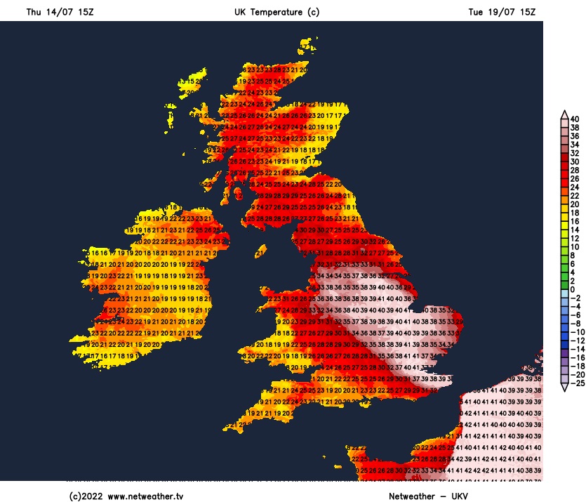
Then other models operational runs started to join to signal an intense heatwave building north across western Europe, with a few starting to show 40C across England too. GFS was starting to show temperatures as high as 42C in eastern England. We began to think GFS was overdoing temperatures, given in other parts of the world the model has been shown to be too dry with air in the boundary layer near the surface, due to problems simulating soil moisture – air interactions – that has been noticed in the USA when compared to observations. Basically, the drier the air forecast, the higher the temperature will get. Furthermore, the well-respected European ECMWF model, often referred to the top performing global model, was run after run not showing 40C or more as well. So it seemed unlikely 40C could be reached in the UK. But with more and more models over consecutive runs, GFS day after day with each run, even more high resolution models, such as the UKV, showing 40C or higher, it seemed a growing possibility.
15z UTC run from UKV on Thursday 14th showed 41C over eastern England for Tuesday 19th July:
And that one GFS ensemble member way back on 30th June turned out to be right! OK, the ensemble member showed 40C for Friday 15th when in fact 40C was reached 4 days later on the 19th. But that far out it was first to pick up on an extreme heatwave around mid-month.
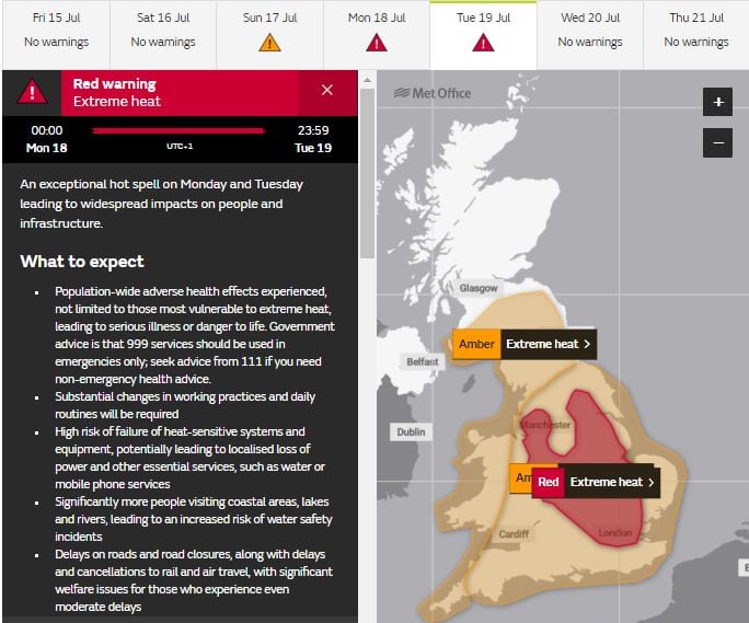
The pulse of extreme heat, with temperatures reaching in excess of 35C, fortunately only lasted two days of Monday 18th and Tuesday 19th, culminating in 40.3C on Tuesday. But the heat was building before then too, with temperatures in excess of 30C the previous week. Then at the end of last week into last weekend, a pulse of extreme heat surged out of NW Africa across Iberia and France bringing record highs, Portugal saw 47C on Friday 15th, the hottest July day on record. The same day, the Met Office, for the first time, issued a red ‘Extreme Heat’ warning. The warning was for Monday 18th July 2022 until Tuesday 19th for exceptional, perhaps record-breaking temperatures by day and night.
The extreme heat over Iberia and France last weekend then surged north over the UK to start this week. A slow-moving cut-off low west of Iberia acted as heat pump, sucking intense hot air out of NW Africa across western Europe over the weekend reaching the UK through Monday and Tuesday. Intense high pressure over central Europe also helping drive intense heat north on its western side. The jet stream configuration that led to the record-breaking heatwave seems to be coming more common too with climate change, a double jet stream over Europe, with a stronger polar front jet stream to the north of the UK and weaker wavy southern jet stream over southern Europe leading to extreme heat over North Africa more likely spreading north over Europe at times during summer.
Watch how hot air is sucked up from NW Africa across Iberia, western France and towards the UK by low west of Iberia between Thursday last week and Monday:
Britain never recorded a 100-degree temperature before 2003, when 38.5C or 101F was reached in Kent. But 100 was exceeded again in July 2019 and then on Monday as the extreme heat set in, with Santon Downham in Suffolk reaching 38.1C (100F). Wales saw its hottest day on record in Monday, with 37.1C reached at Harwarden, also Jersey saw its hottest day since records began, with 37.9C. These temperatures then led to the warmest night on record, with temperatures not falling below 25°C in a few places, exceeding the previous highest daily minimum record of 23.9°C, recorded in Brighton on 3rd August 1990. The temperature didn’t fall below 25.8°C at Kenley airport, south London, and 25.9°C at Emley Moor, near Huddersfield, West Yorkshire.
Tuesday saw the peak of the two-day extreme heatwave. Until Tuesday, the UK’s highest ever temperature record had stood at 38.7C (101.7F), set in Cambridge in July 2019. This was then surpassed before noon on Tuesday, when the thermometer in Charlwood, a village in Surrey near Gatwick Airport to the south of London, reached 39.1C Celsius. Then, not long after, London Heathrow reported a temperature of 40.2°C at 12:50 BST. Then, a few hours later, Coningsby, a village in Lincolnshire, reached 40.3 degrees (104.5F) – the new highest temperature ever recorded in the UK. Over the channel, the temperature in Paris reached 40.5C on Tuesday (104.9 F), the city had recorded temperatures above 40 only twice before, in 1947 and 2019.
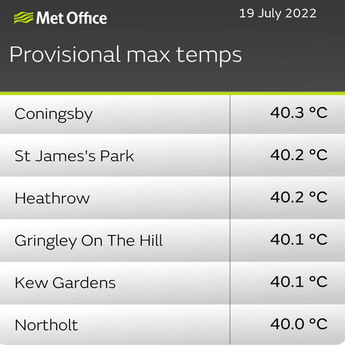
At least 34 sites broke the old British record of 38.7C set in 2019 on Tuesday, according to the Met Office, including at least six that reached 40 C. Scotland blew by its old record of 32.9C, with a reading of 35.1C at Floors Castle near Kelso in the Scottish Borders.

Extraordinary, record-breaking heat, affect large areas of the UK, not just the far south like other heatwaves. The heatwave, after two days of extreme heat, broke down fortunately later on Tuesday, as low pressure system moved in from the southwest and associated cold front shunted the extreme heat eastwards away from the UK, with some thunderstorms across parts of southern England as the cold front moved through. The extreme heat plume moved over continental central and northern Europe further east on Wednesday, with Hamburg in the north of Germany smashing its all time highest temperature record, reaching 40C (40.1C) for the first time in recorded history. Denmark saw it’s second highest temperature ever, with 35.9C at Abed. Highest temperature ever recorded was 36.4C recorded at Holstebro on 10th August 1975.
 Credit: UK Met Office
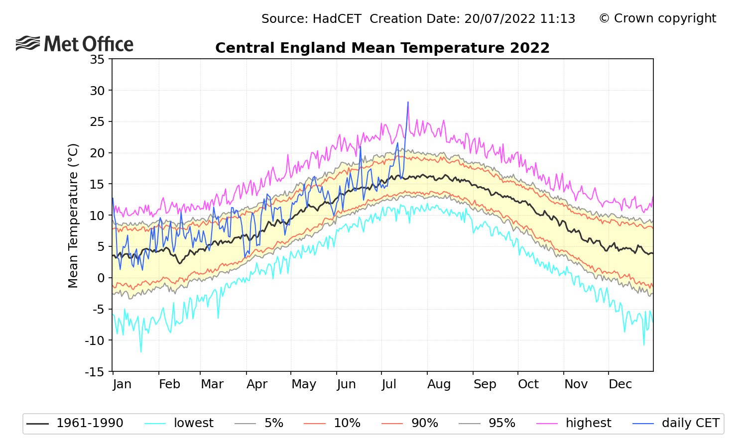
But the magnitude of the records broken in the UK during the extreme heatwave at the start of the week is quite staggering. The previous high temperature record got broken by quite some margin, the new record 1.6C higher than the previous set in July 2019. The record 3 years ago beat the 2003 record by 0.2C. But when you look at the daily mean temperatures for Central England, which has observations every day going back to 1772, before the latest heatwave, the hottest daily average ever recorded was 25.2°C. This week’s extreme heatwave obliterated that record by 3C, by provisionally reaching 28.1°C.