


Blustery today and tomorrow but with some fine weather this weekend. Ex- Hurricane Gert will be closer by Sunday but looks to bring warmth along with possible heavy rain.
We are in for a blustery spell over the next two days with fresh west/NW winds blowing over the UK. Then a bit of a lull at the weekend with less windy and bright, fine conditions before and Atlantic low pressure moves in, containing the remnants of Hurricane Gert. This will bring extra-tropical warmth for Monday and Tuesday but also some heavy and persistent rainfall to part of the UK. There doesn’t seem to be concerns about the wind strength, at the moment, and it’s windy today anyway when Gert is on the other side of the Ocean.
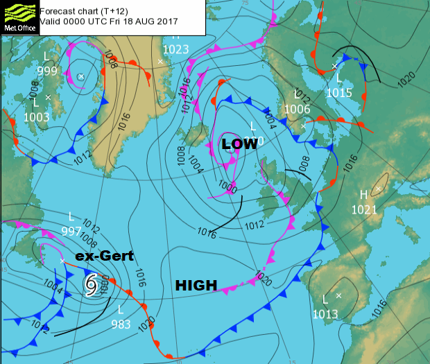
It won’t be as warm today as yesterday when the top temperature was 25.4C in Suffolk. Many places saw a lovely day once the early rain had cleared off. Low pressure is away to the north and the UK is in brisk westerly flow and along with heavy showers, it’s a bit like autumn out there. The main clusters of showers will be across Scotland, with the lower level Flood Alerts in place for eastern and NE Scotland. There could be localised problems for northern England too.
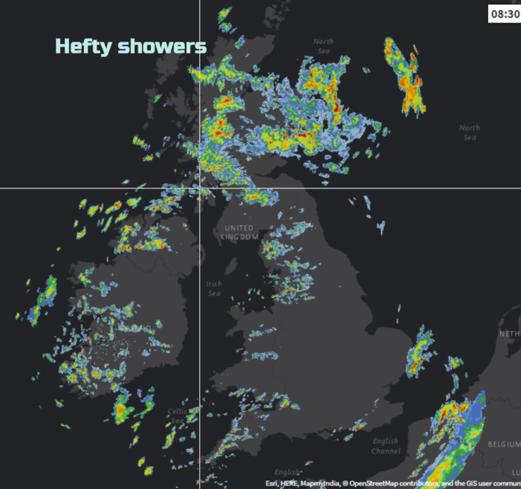
The radar shows there is rain elsewhere, bits clearing East Anglia and more showers coming into Northern Ireland, Wales and NW/SW England. There are other areas with blue skies and sunshine, it is a mixed start to Friday. Temperatures will rise to 21/22C in the sunny spots for SE Britain. Under the hefty downpours in the wind it will feel cooler today.
The showers do push a bit further inland today, but England will see fine and dry weather in places, yet others will get showers, especially from lunchtime onwards. Through the afternoon some of these showers will be heavy with the risk of hail and thunder. See Nick Finnis's Convective forecast.
By this evening the low pressure in the north is easing away, so the rain peters out over Grampian. Showers continue to feed in from the far NW and a cluster of more persistent rain looks to be heading for Wales, Cheshire and then the Peak District through this evening. This could include some heavy and thundery bursts too. Many places become drier and clear although showers continue to affect the NW Highlands.
Saturday gradually improves. Many areas will have a fine bright day although still windy. There will be a fresh to strong west wind blowing, worth thinking about if you are camping or having an outdoor fete or event. Eastern areas might reach 19C further west only 16C
The winds ease during Saturday evening and it turns cooler. Most of the showers fade before high cloud begins to edge in from the southwest, bringing patchy rain to Devon and Cornwall. This is the first front linked to the Atlantic low containing the remnants of Gert. This band seems to falter as it comes up against the ridge of High pressure over the UK
Sunday
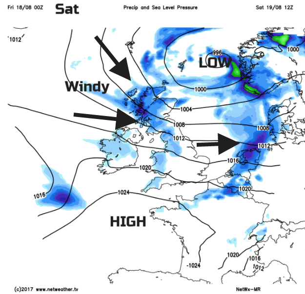
Sunday will be an in-between day. The showery, windy low pressure to the NE is pulling away and the low with the tropical energy to the west won’t quite be with us. So hopefully there will be a lot of fine, bright weather about and lighter winds. At some point, cloud and rain will increase from the SW and there is a lot of uncertainty about when this will happen. Either by lunchtime on Sunday, or at the end of the weekend. It does look like the West Country will see some damp weather and this could reach into Wales too. This southern rain fades, but as th3e cold front moves over Ireland this is when the heavy and persistent rain could start.
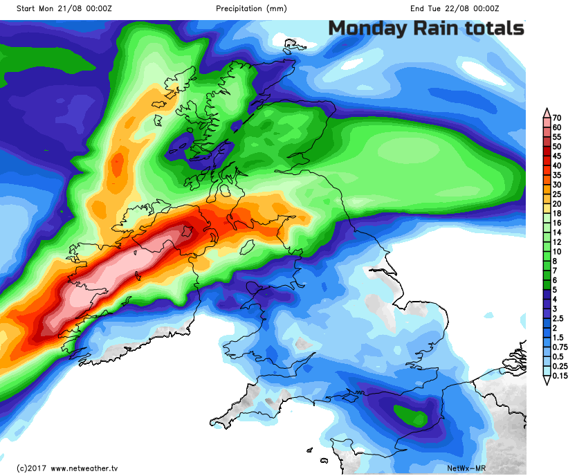
This gives an idea of possible rainfall totals during Monday, so starting Sunday night. The areas may shift but it shows a difference from the recent showery speckles.
The Environment Agency is already highlighting a possible flood risk for Sunday into Monday, with northern England and north Wales looking prone, along with Scotland and Northern Ireland.
Much of central and southern England could miss this rain and end up in the warm sector of a low pressure with tropical origins. This means some very warm, humid air for the start of next week.
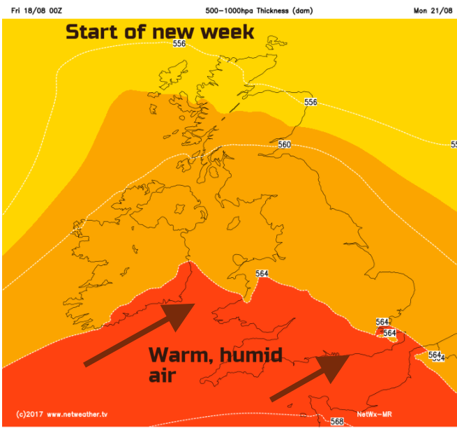
Temperatures could rocket and there are signs that thunderstorms could break out for inland southern Britain on Tuesday. It will feel quite different after the fresh coolness for the end of this week. So, although there could be heavy and persistent rain for some, Gert could result in a spell of summer muggy warmth for the start of the new week. Keep in mind the uncertainty from Sunday onwards.
It does look like Gert will give the jetstream a good old kick and upset this monotonous west to east flow which has made our UK summer so mediocre. So with a few undulating ripples in the flow, we could see more variation next week, That's not a promise of amazing sunshine and heat but just not the endless flow of blustery showers off the Atlantic.

SEPA Flood alerts for Scotland
Environment Agency 5 day flood risk


