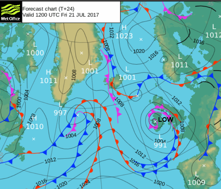
Wet and windy weather coming in off the Atlantic as a low pressure sticks around over the weekend. If you are travelling, consider the conditions - surface water and gusty winds.
This morning there is sunshine for eastern England and northern Scotland but a whole mass of cloud, wind and rain whirling over the rest of the UK. A low pressure, which wouldn’t look out of place on an autumn pressure map, is moving in off the Atlantic and bringing blustery, wet weather for many. Remember the start of the week; heat and sunshine, well it's a very different end.
Today looks very wet for Wales, Isle of Man and SW & NW England. Southern Scotland will also see a good deal of rain as will Northern Ireland. As more school start their summer holidays today the Met Office have issued a Yellow, Be Aware warning for Heavy Rain over SW Britain.
“A brief spell of heavy rain and strong winds could lead to difficult travel conditions, as the summer holiday season starts for some. Standing water and spray may make journeys longer, and could lead to minor surface water flooding. Winds could be sufficiently strong to cause some bridge restrictions and bring down branches from trees. Conditions could also be hazardous for those engaged in outdoor activities.”
Many parts of western England and SW Scotland will have horrible conditions this morning with gusty winds and heavy even thundery downpours. There will be strong SE to SW winds around coasts and over hills and the Welsh mountains, even gales in exposure. The heaviest rain will be from a line heading over Wales and SW England. See Nick's Convective Forecast.

This frontal band will bring heavy rain, it’s quite slow moving as it creeps eastwards and could include thunder and lightning. As you would imagine, under all of that it is going to feel cold, especially in the winds. However, ahead of the frontal bands, there is still some warmth to be had today. Eastern England could see 22 or 23C and parts of Scotland, up to 20C.

So windy everywhere, heaviest rain for western Britain with the early rain clearing from most of Northern Ireland and brighter warmer weather in the far north and east.
The line of heavier rain slowly makes its way over the Midlands and central southern England with more hefty downpours. Eastern and northern Britain have a windy evening but slowly the winds ease off across the UK as the low begins to fill.
The Weekend
Around the rotation of the low pressure, bands of showers move across Wales and England, appearing from the SW. These wander along the Channel as the main band of rain reaches northern and eastern England on Saturday morning. Northern Ireland and Ireland also see further showers to start the weekend, all with bright or sunny spells in between.

It looks like the band of heavier rain will settle over southern Scotland on Saturday maybe trailing over NE England. It will pep up and give heavy downpours even a rumble of thunder, in an easterly wind. Northern Ireland, Manchester and much of central and eastern England should escape with lengthy, fine and bright spells. Away to the SW, hefty showers continue to feed in, bring the risk of further thundery downpours, hail and large rainfall totals. Some areas of southwest Britain will see shower after shower and others missing the worst and getting more brightness in a brisk SW wind. The highest temperatures on Saturday will be for sheltered NW Scotland, up into the low 20sC. Other parts of the UK will manage only mid to high teens.
By Saturday evening the showers will be more scattered across Wales and England, but you will be unlucky to catch one, yet the threat remains. It seems there will be even more rain for Scotland (away from the NW) with some areas in the east having a really quite miserable day.
Sunday
Sunday is quite tricky to describe as low pressure sags away into the North Sea leaving further rain or showers. Some areas will see a mainly dry day with bright spells and lighter winds, but eastern Scotland still looks at risk of persistent rain and there will be plenty of heavy, slow moving showers across Britain giving and unsettled picture. Top temperatures look to be around 21C with a west to NW breeze.

Next week
Monday looks more settled and a bit warmer. Tuesday looks okay with just a few showers and light winds, so not too bad if this is the start of your school holidays, after this turbulent spell.