


Cloudy & damp, though feeling warm & muggy. Brighter and fresher conditions spreading south on Sunday. Dry & sunny to start the new week, turning hot and humid in the south by mid-week, with risk of thunderstorms for all.

For many it will be a rather cloudy weekend, with a chance of some rain too. But it will feel warm and muggy today, thanks to a humid southwesterly flow drawn in all the way from the sub-tropical North Atlantic. Fresher and brighter conditions move down across northern areas on Sunday, while staying cloudy but warm and humid across southern parts. Early next week the weather is looking largely fine and dry, however it will turn increasingly hot and humid across southern areas on Tuesday and Wednesday, with an increasing threat of thunderstorms developing and spreading north. Cooler, fresher and more changeable conditions on Thursday and Friday, as low pressure moves in off the Atlantic.
Next week
For now, weather fronts moving in off the Atlantic overnight are bringing mostly cloudy skies this morning – with occasional outbreaks of rain spreading east across England, Wales, Northern Ireland and eastern Scotland, while across western Scotland there will be more persistent and heavy rain. It should turn drier from the west this afternoon across much of England and Wales, with some brightness or sunny spells developing inland away from western hills and coasts, where there will be occasional patchy light rain or drizzle along with hill fog. Staying rather wet across western Scotland throughout today, the rain persistent and heavy over higher ground. Eastern Scotland will be drier, with a chance of some brightness, though often cloudy with a risk of occasional light rain at times, this turning more persistent during the evening for a time.

A warm and humid day for all in the moist southwesterly breeze, which will be brisk towards western coasts. Temperatures reaching 17-20C widely, perhaps 21-22C across SE England and East Anglia.
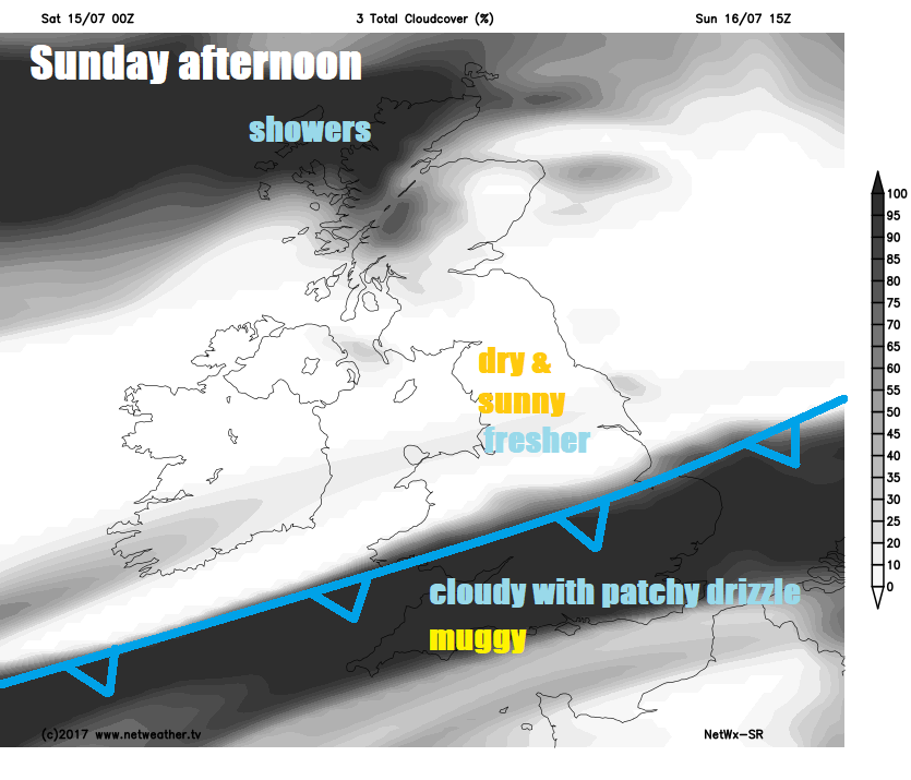
Rain for a time this evening across Scotland and Northern Ireland, before edging southeast across northern England, Wales and Ireland during the early hours of Sunday. The band of rain moving southeast across central areas overnight is a cold front which will separate cooler, fresher and clearer conditions moving in across Scotland and warm, muggy, cloudy and occasionally damp conditions to the south. Temperatures falling no lower than 16-17C across much of England and Wales, so a bit uncomfortable for some, but across Scotland and Northern Ireland falling to a more comfortable 10-13C.
A cloudy, damp and humid start across England and Wales on Sunday, but brighter and fresher conditions across Scotland and Northern Ireland will spread down across northern England, The Midlands and Wales through the day. Although Wales and the Midlands north will have a mostly dry and sunny afternoon, there is a risk of showers across NW Scotland. Staying rather cloudy, warm and humid across southern England and East Anglia, low cloud thick enough to bring patchy drizzle or light rain, particularly over hills and coasts where it will be misty too. Highest temperatures across SE England – where we could reach 24C in London, elsewhere, reaching 21C in Cardiff and Norwich, 20C in Plymouth, 19C in Manchester and Belfast, 18C in Glasgow and Aberdeen.
A few sporting events this weekend – Wimbledon mostly cloudy today and may see some passing showers early this afternoon, but tending to become drier and brighter by the evening. Sunday will be cloudy with limited brightness with a risk of the odd spot rain, but it may stay dry. Silverstone tomorrow may start cloudy with the odd spot of rain, but it should quickly brighten up and stay dry into the afternoon.
A ridge of high pressure will build in from the Azores to start the new week, so Monday is looking mostly dry and sunny for the whole of the UK, perhaps a cloudy start with the odd spot of drizzle across southern counties of England as a cold front slowly clears here and it may stay cloudy along the south coast. A pleasantly warm day for most, temperatures reaching 20-23C generally, perhaps 25C across SE England.
Another dry sunny day on Tuesday, with high pressure in control for most, turning increasingly humid and hot into the afternoon across southern England and south Wales – where temperatures will reach 25-27C, elsewhere temperatures reaching 20-23C.
A risk of thunderstorms spreading north across southern areas of England and Wales Tuesday night, as plume of humid and unstable air advances north out of France. These storms continuing to develop and spread north across England and Wales during Wednesday morning, reaching southern Scotland by later afternoon while more persistent rain arrives across northern and western Scotland along with N. Ireland. Drier, sunnier weather following across southern areas, but it will be hot and humid towards the southeast, where there could be a risk of further thunderstorms developing in the afternoon.
Outbreaks of heavy rain with thunder across northern and eastern areas Wednesday night eventually clearing east to allow cooler and fresher conditions in from the west on Thursday, which will prevail on into the weekend. Risk of some showers spreading east Thursday and Friday, but also some sunny spells.


