Further changeable and cyclonic conditions ahead, but potential changes in the longer term
Issued at 1500BST on Tue 11th July based on Tue 11th July 00Z Model Runs
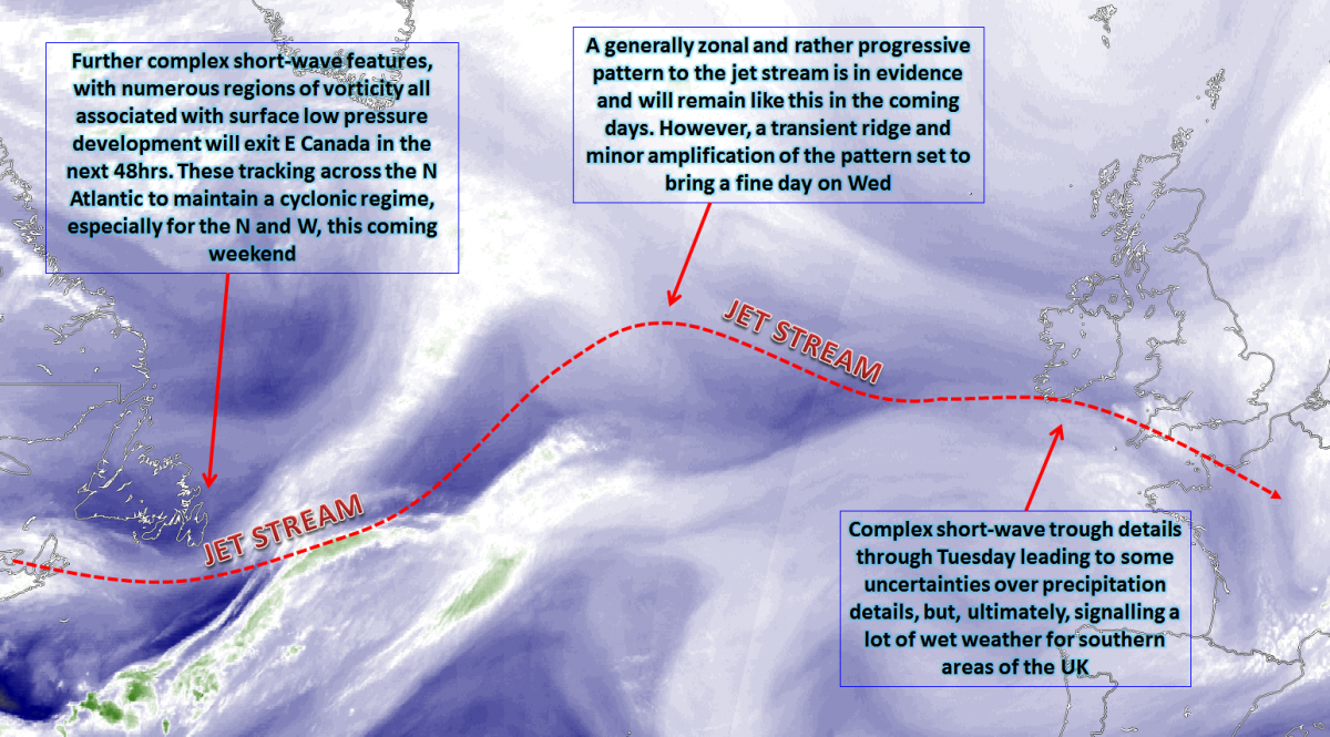
Key Points
Discussion:
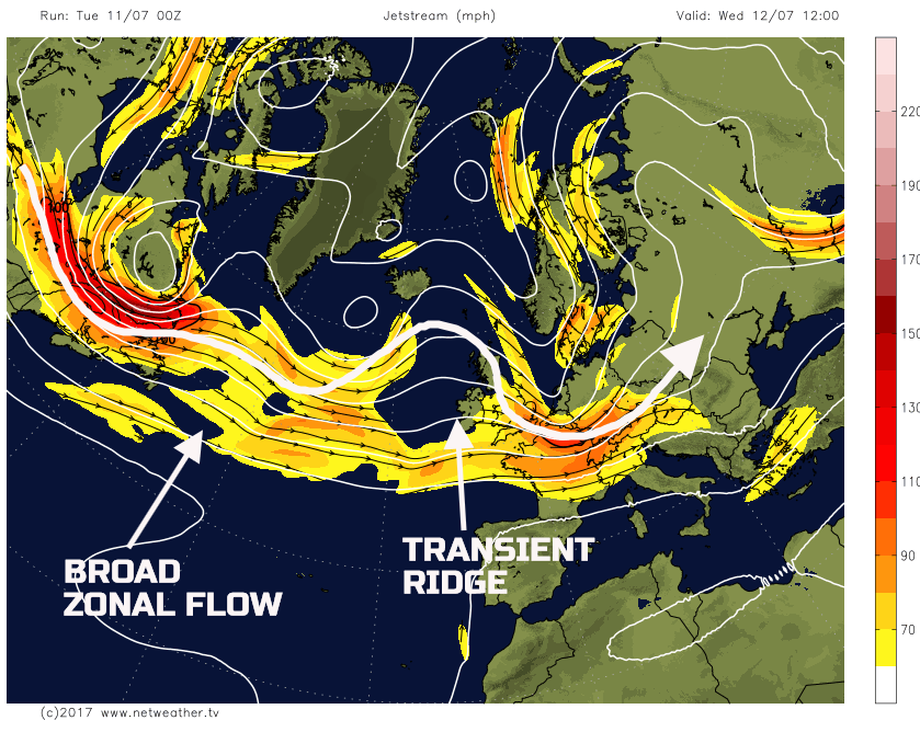
Wed 12th July: During Wednesday the UK will experience quite an abrupt change in the weather to a more anticyclonic type. While this will be short-lived, primarily because the ridge is transient and embedded within a more zonal flow, the outcome will be an enjoyable day of weather. The moderate and heavy rain and showers of Tuesday will have cleared away, perhaps still present across the extreme SE of England first thing. Otherwise NVA and CAA down into the UK will be aiding to lower Td’s, bringing nothing more than fair Cu diurnal cumulus infill, and leading to a dry and sunny day for many areas. The transient ridge is highlighted well by the 00Z GFS, but all the main GM’s are in good agreement for this now.
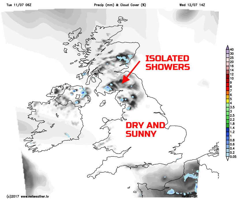
The residual cyclonic pattern, in association with a surface low, will still be bringing frontal cloud and some rainfall to the far SE first thing. Otherwise bright or sunny spells will be widespread, these prolonged at times and with a marked subsidence inversion any Cu development will be shallow. However, there could be some local convergence zones across parts of Scotland and N England, that may result in a few isolated showers, but these will be the exception to the rule. Despite the lower Td’ air mass, temperatures will respond to the mid-July sunshine, and it will be a decent day of weather, especially so after the wet weather on Tuesday.
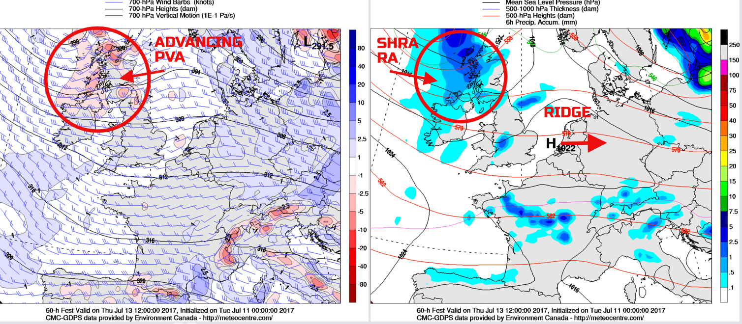
Thu 13th July: Into Thursday and it will be a dry start to the day across many areas of the British Isles, after a locally chilly night as well, especially rurally. The transient ridge will, however, begin to be pushed away to the east as the more zonal and progressive flow across the N Atlantic dominates. A lot of dry weather is forecast to continue across central and southern areas of England, but the more unsettled weather will return to the N and W. There are some uncertainties over precipitation amounts. The ARPEGE, EURO4 and some of the GM’s differ as to how much forcing will accompany a set of fronts into the N and W. However, it is likely that Scotland, Ireland and N England will see an increasingly cloudy day with some rain and showers at times. The declining transient ridge is highlighted well on the below chart. Equally, continue to notice the zonal pattern, particularly given the time of year, despite some minor amplification that will impact condition in the coming few days.
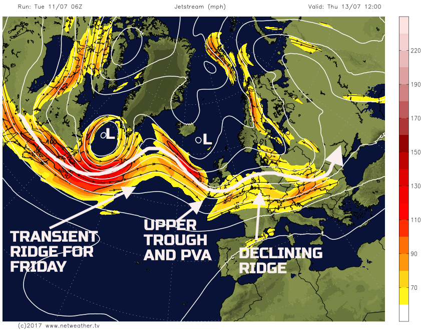
The 00Z GEM model highlights the evolution well through Thursday. The ridge declines to the E as a set of frontal zones, associated with low pressure to the NW of Scotland, move into the N and W. At first the forcing associated with the fronts is relatively weak, but would still bring outbreaks of rain and showers into Scotland and Ireland during the day. There are some model differences over how sharp the upper trough will become through the day. However, the combination of the advancing trough and some diurnal, solar input will likely mean that the showers will become locally heavy across parts of the N, with some longer spells of rain. It is probable though that many southern areas of the UK, areas furthest away from the advancing PVA, in association with the trough, will remain dry and bright.
Fri 14th July: Overnight into Friday and there is a good model agreement between the UKMO, ECMWF, GFS and GEM for the upper trough and associated precipitation to decline away to the E of the UK. Some residual overnight rain or showers could still be in evidence first thing, across E England, but this will clear and with then another transient ridge crossing the UK.
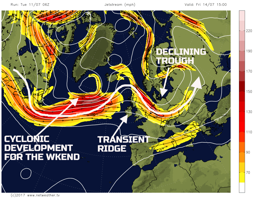
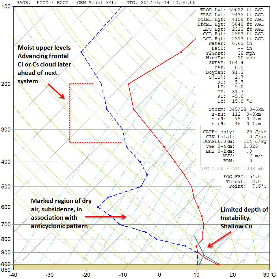
This particular ridge is, at the moment, unlikely to have the same amplitude as the one that will arrive on Wednesday and, as a result, will quickly decline away to the E later in the day and overnight into Saturday. However, for much of the day, it will produce more of an anticyclonic NW’ly flow. Some scattered showers are possible, but otherwise many areas will be dry with some bright or sunny spells. Forecast soundings for Friday highlight the expected weather particularly well, including the forecast sounding for 12Z for Manchester. Only shallow instability is forecast, with limited Cu development at the moment. Also, the marked region of dry air between 700mb and 600mb highlights the subsidence and general anticyclonic and NVA air mass into the UK. Interestingly too, is the increasing signal for more moisture at the top of the troposphere. This moisture will be directly related to the next advancing frontal system, from the W, later in the day, bringing Ci and perhaps Cs well ahead of the main surface low during Friday afternoon.
By the end of Friday the transient ridge will be declining quickly to the E and the cyclonic development, for the weekend, will bring the frontal cloud into Scotland and Ireland. Outbreaks of rain and drizzle will soon follow, and with some marked vorticity and WAA coming together then some heavy rain is possible for the N during Friday evening and overnight, as exampled by the 00Z GEM for Sat 15th 0000Z.
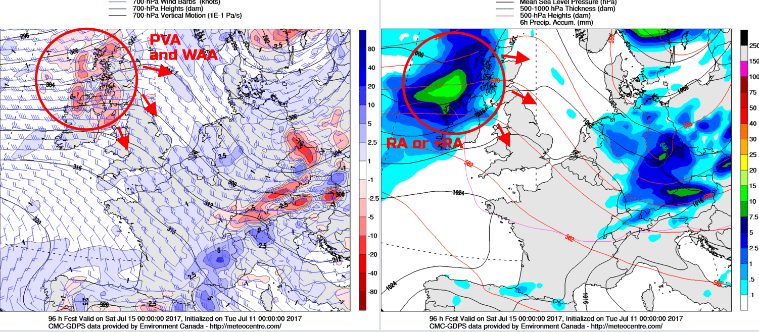
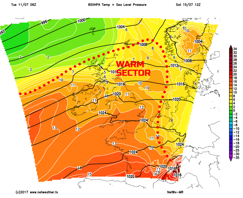
Sat 15th and Sun 16th July: So, we move into the forthcoming weekend and, it is likely to be a mostly cloudy and damp start for many areas. The frontal precipitation that will move into many N and W areas late on Friday will have advanced down across many regions of the UK into Saturday. Accompanying this will be a marked area of WAA, with a +14C to +16C WBPT plume filtering down across the UK too. As a result, cloud amounts will be large with sporadic areas of rain and drizzle. It would seem, given some model agreement, that main upper trough and associated forcing may well overrun the surface fronts, or at least clear away to the NE. As a result, this means that little in the way of heavy rain is likely on Saturday, but it will probably be a mostly cloudy and damp day. The marked warm sector across the UK is highlighted well on our medium range model.
This synoptic pattern across the UK will mean that many western hills of England, Wales and Scotland will see some persistent light or moderate, rain or drizzle during the day, along with some possible low cloud and hill fog too. The cloud may well break to the east of high ground through the afternoon, so E Scotland and E England favoured locations for some brighter and drier weather, but otherwise, it will be a cloudy and damp day.
Through into Sunday and there is then considerable uncertainty over the detail. The frontal zones that will move SE across the UK on Saturday may well be at risk of developing a frontal wave, to the W of the UK. The frontal wave is being picked up by most of the GM’s, but how this feature develops is uncertain. Using the 00Z EC EPS as a guide, it is possible that a returning region of the prolonged frontal precipitation could move back across parts of Ireland, Scotland and N England later in the day, while many southern areas remain dry. It is, overall, though likely to be another cloudy and damp day for many N and W areas on Sunday either way, with still the best conditions across the S.
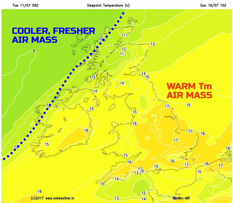
One thing of importance will be the warm air mass across the UK during the weekend. Despite this coinciding with rather cyclonic conditions, it will, given the time of year, lead to a particularly warm and humid day, especially across England and Wales. At the moment Td’s more than +15C or +16C are forecast, perhaps nearing +17C across E England. So a warm and humid weekend is most certainly to be expected. Note though lower Td’s just to the NW, of which will follow SE into next week as cooler and fresher conditions return.
Medium and Longer Term 17th July onwards:
Looking ahead and the changeable weather regimes are likely to continue into the beginning of next week with cooler and fresher conditions filtering SE across many areas. Some further spells of rain and showers are possible too, of which is signalled by most of the medium range GM’s. However, beyond that time frame, we could well be looking at a possible change in the broader patterns across the UK and, potentially, the N Atlantic as well. We are keeping a close eye on this as it could well be influential for the second half of the month and we’ll have more details on this in the coming few days, so stay tuned.