Cyclonic conditions set to continue to dominate through the end of June and, at the moment, into early July
Issued at 1500BST on Tue 27th June based on Tue 27th June 00Z Model Runs
Key Points
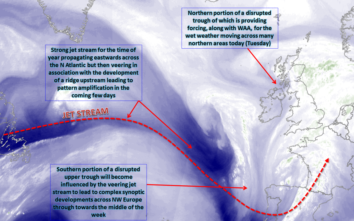
Discussion:
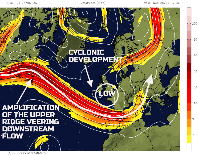
Wed 28th June: As we progress into Wednesday and the pattern across the N Atlantic has a good model agreement. However, there is less agreement regarding the details across the UK. The N Atlantic will see a well-organised jet stream of which will be undergoing amplification across the far W of the Atlantic. This amplification will mean trough extension to the S and SW of the UK, bringing about a trough-ridge-trough pattern across the N Atlantic. It is the veering flow to the S of the UK that will subsequently lead to cyclonic developments as an area of low pressure moves up into the UK during the middle of the week. The UKMO, GFS, ECMWF and GEM models are in all relatively good agreement for this broad evolution.
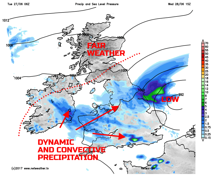
Across NW Europe and over the British Isles, within the central trough, will be some low-pressure centres, but of which will, be combining to produce one larger surface low. Frontal zones will be in evidence, along with the potential for embedded convective activity too. The whole setup is particularly un-summer-like, with both dynamic and convective precipitation expected during the day. While the broader pattern has a good model agreement, the HRES models (EURO4, ARPEGE, et al.) are, quite varied regarding which areas will see the greatest rainfall totals through the day. Overall though, a region of showers and longer spells of rain will be in evidence, first thing, across much of England and Wales. This area of wet weather will then persist, while likely extending westwards into Ireland. Some locally heavy bursts of rain are possible, and it will be unusually cool beneath the wet weather too. The best place for reasonable weather on Wednesday will be across Scotland.
Thu 29th June: Through into Thursday and the pattern across the N Atlantic will continue to amplify in quite an impressive way for the time of year. The trough-ridge-trough pattern will be present, and the UK will be on the forward side of this development, beneath a particularly cyclonic pattern. For the time being, through Thursday, this more amplified pattern will help to keep the low-pressure systems slow moving over the British Isles, maintaining unsettled conditions.
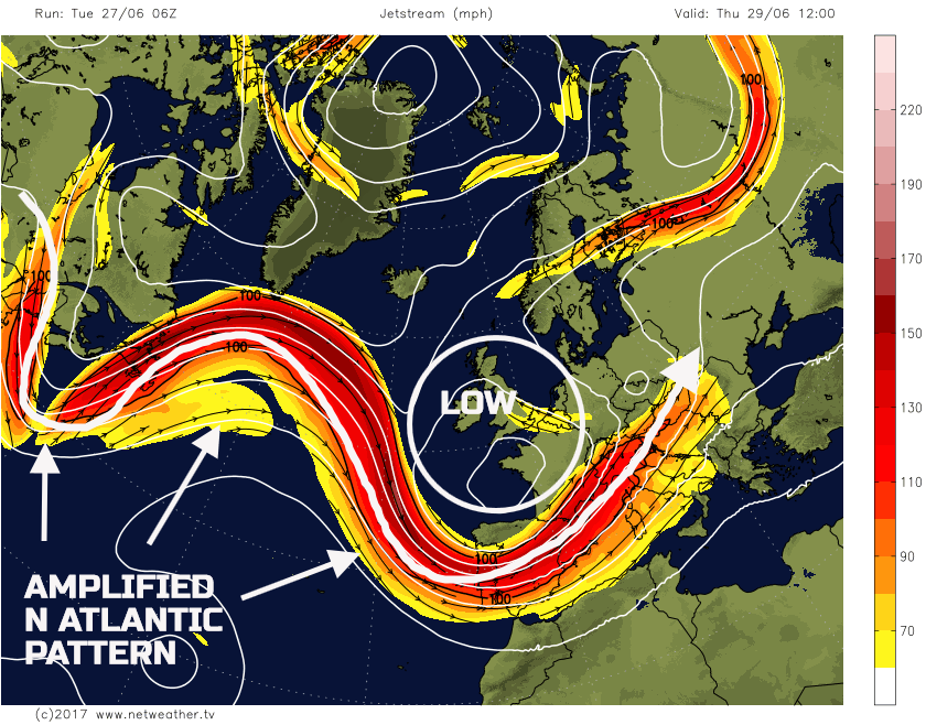
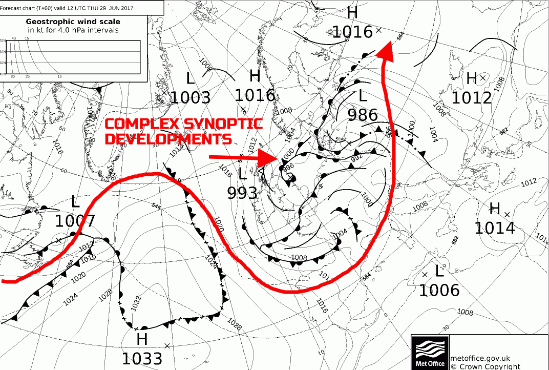
It is, again, the details that are the primary uncertainty, especially regarding precipitation amounts and which areas will experience the most persistent, dynamic, frontal rain. The amplified pattern to the W of the UK, with a general rise in GPH, will combine with the low-pressure, to increase the PGF over the UK. As a result, this means that an increasingly strong N or NE’ly flow will develop across Scotland and Ireland in particular. Winds gusting up to 40mph to 50mph are possible in exposure and this aiding to produce an unusually cool day here for the time of year. The complex synoptic pattern is highlighted well on the UKMO FAX chart for 12Z Thu. The general position of the jet stream, to continue to highlight the amplified pattern, has been overlaid.
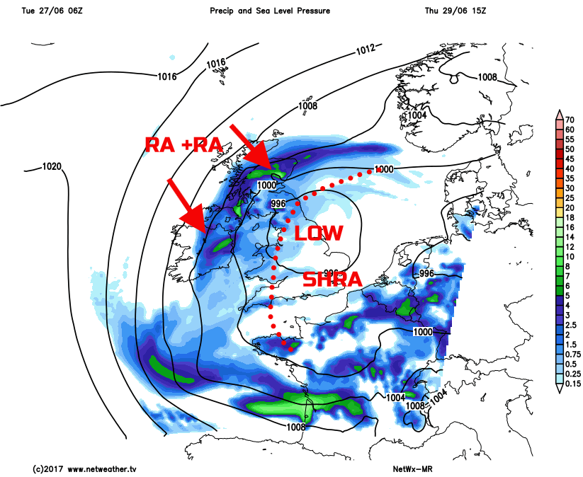
At the moment, using primarily HRES models to get some detail, it would seem that more persistent frontal rain will affect much of Scotland, Ireland, N England, Wales and SW England through the day. Increasingly large rainfall totals are possible by this point, perhaps with some of these areas seeing more than 60mm, when combined with rain from previous days too. To the S and E of this region, so across more central, southern and eastern areas of England, more of a convective regime may well develop, especially if some solar input can occur due to cloud breaks. Using our MR model as a guide, this precipitation pattern is in evidence across the UK. Note, as well, the proximity of the isobars across more N and W areas, indicating that strong N or NE’ly flow.
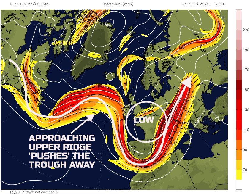
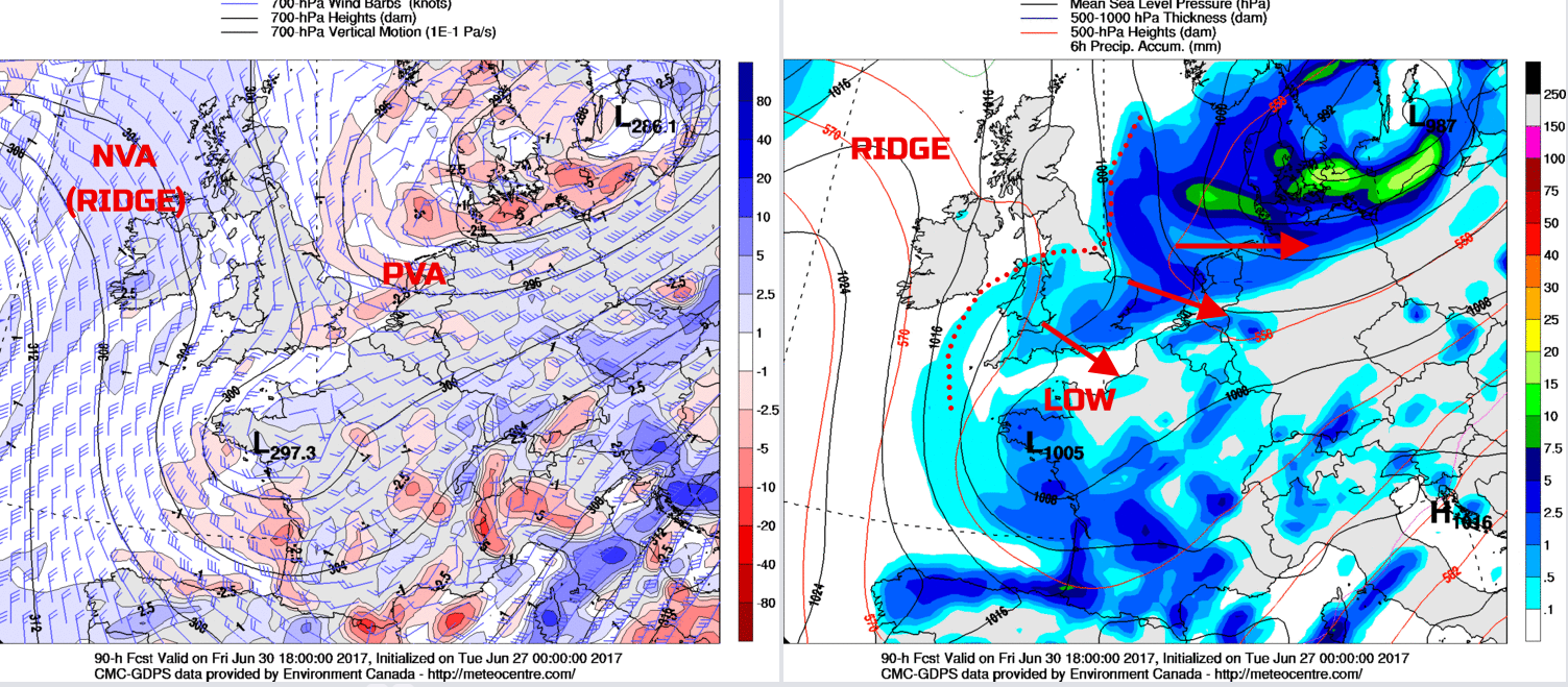
Fri 30th June: We end the working week with the GM’s (UKMO, ECMWF, JMA, GEM and GFS) in, overall, good model agreement regarding the broader synoptic pattern. Eventually, despite the amplification, the overall flow will become more progressive by the end of the week, as the ridge arrives from the W. What this means that is the upper trough and complex cyclonic pattern will be pushed away to the E and SE of the UK during the day. The progressive pattern will, however, have implications for the weekend's weather, but it will signal an improvement in the weather during the day.
Many areas of Scotland and Ireland, in particular, should end the week with a reasonably dry day, especially after the wet weather on Thursday. Some bright or sunny spells are likely through the day, but a moderate or fresh, locally strong N or NE’ly wind will still be in evidence. Across England and Wales, it is here that more unsettled conditions will linger for longest. Another cloudy and wet start is forecast with outbreaks of rain and showers. However, a trend, through the day, will be for the precipitation to decline to the SE, but probably not clearing the far S and SE of England until late on, timings of this are uncertain. As the upper ridge builds in, it will then mean Friday night for much of the UK will be dry with clear spells and it will be quite chilly too. The 00Z GEM model highlights this general improving scenario through the day from the N and W as NVA (Negative Vorticity Advection) replaced PVA.
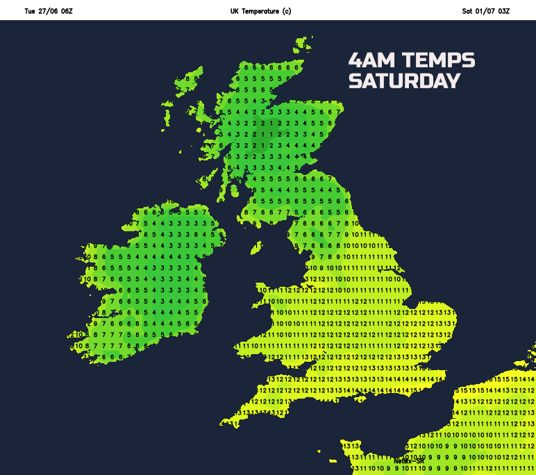
The unusually chilly night, for the time of year, is highlighted well by our MR model for the early hours of Saturday. Especially across Scotland, Ireland and N England minimum temperatures will be low enough for ground frost into early Saturday morning, a relatively rare occurrence at this time of year. Temperatures across much of England and Wales though are markedly higher, but this is subject to change, and the model may well be keeping too much cloud across England and Wales, so lower temperatures across England and Wale, than shown, may develop.
Temperatures through the rest of the week will be rather varied. Beneath the wind and rain across the N and W of the UK then temperatures on Wednesday and Thursday will be particularly depressed, perhaps no higher than 11C or 12C. Temperatures, will, overall though be higher across England and Wales, ranging between 15C and 20C.
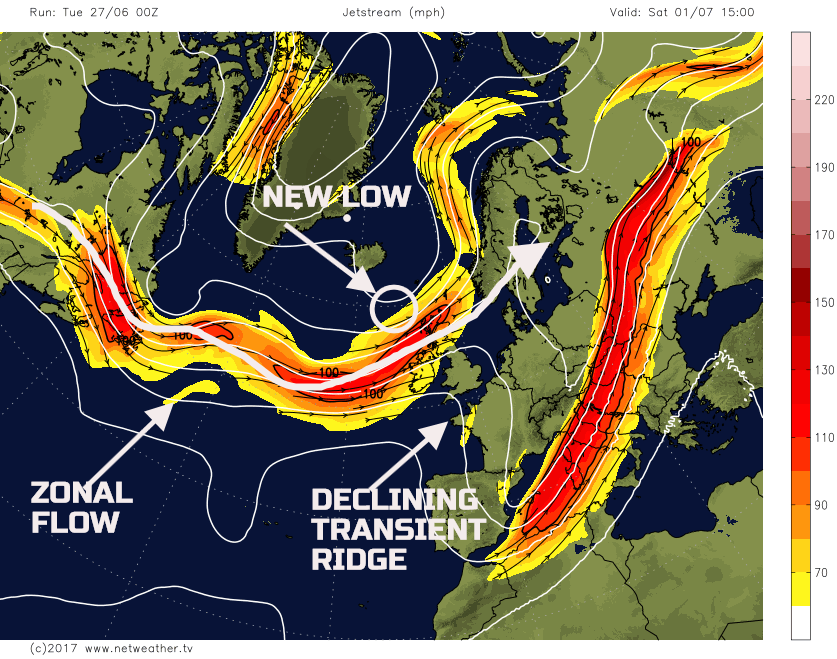
Sat 1st and Sun 2nd July: So, as we move into the weekend and the more zonal flow across the N Atlantic will begin to dominate the weather across the UK. There is, given the time frame involved, actually a model agreement over the weather pattern for the UK. The upper ridge that moves in during Friday and Friday night will decline to the E and SE of the UK into Saturday. As this feature clears away, it will then allow the more zonal pattern to develop. A set of frontal systems, associated with an area of low pressure to the NW of the UK, will then move into the N and W the UK during Saturday.
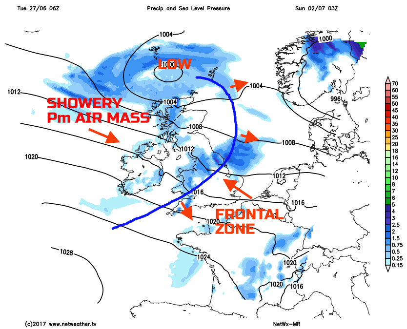
As a result, it will be a chilly start for much of the British Isles, but thickening cloud and outbreaks of rain will already be moving into parts of Scotland and Ireland. The outbreaks of rain and showers will then extend SE through the day. The timing of this is uncertain, but it is likely that more central, southern and south-eastern areas of England will have a fair weather day on Saturday before rain arrives by the end of the afternoon. These outbreaks of rain and showers then clear to leave SE England, most probably early on Sunday morning, leaving behind a legacy of sunshine and showers, especially in the N and W of the UK on Sunday, along with a Pm air mass across much of the UK. Temperatures, over the weekend, will be near or slightly below average, always warmest across the S and SE, coolest further N and W of the UK in this synoptic regime.
Medium and Longer Term 3rd July onwards:
Looking further ahead, into the opening week or more of July and while a transient ridge may well bring some brief settled weather on Monday the 3rd, the overall consensus at the moment is for further changeable and unsettled conditions. Using the latest GFS ENS mean (below) the overall flow well into the opening week is forecast to be quite zonal, with low-pressure always influential to the W and NW of the UK. There is support from the EC EPS, and many of the individual EC members show quite a cyclonic output. As a result, further spells of rain and showers seem likely into early July, perhaps especially so across parts of the N and W. Towards the middle of the month there are some tentative signs of a possible change to more settled conditions, but there is low confidence in this evolution. The reason for this is because of the time frame involved and the rather erratic pattern that has been dominating the summer so far.