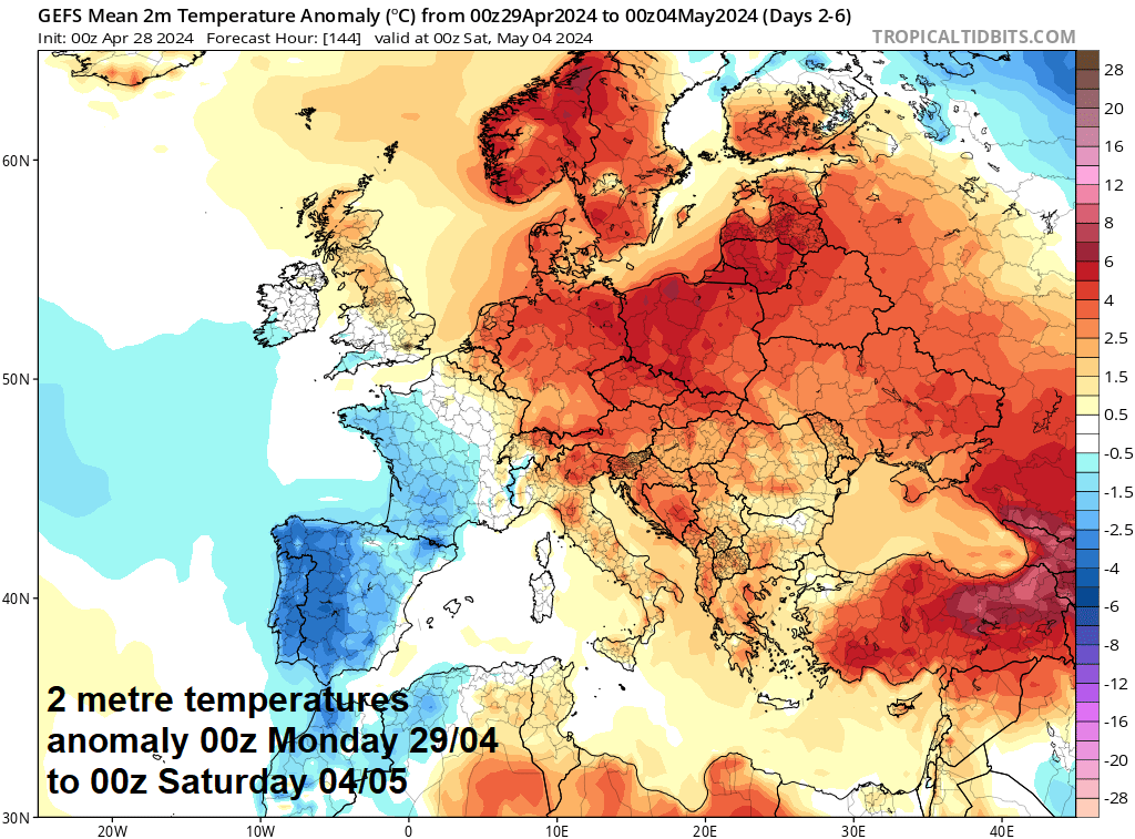
Following a cool second half of April, it will turn warmer as we head into May this week. However, with low pressure close by, there will be some rain at times, more particularly in the west; eastern areas will be drier, sunnier, and warmest.
The second half of April so far has been cool and showery for many, some days decidedly chilly and cooler than some days we had last winter for daytime highs. The good news is, it looks set to turn warmer in the coming week, more particularly in the south and east – where temperatures have been well below the local average recently. Temperatures reaching the high teens towards the southeast. The bad news is there will still be some rain for many at some points in the week ahead. Though for eastern areas it will be dry much of the week.
Warming up this coming week, more particularly in the east
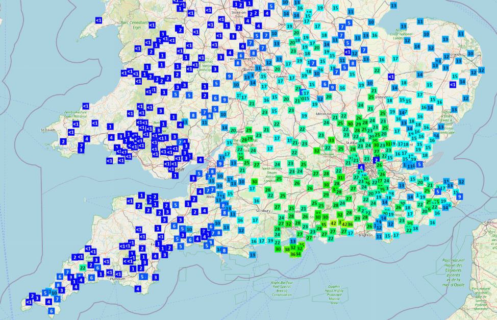
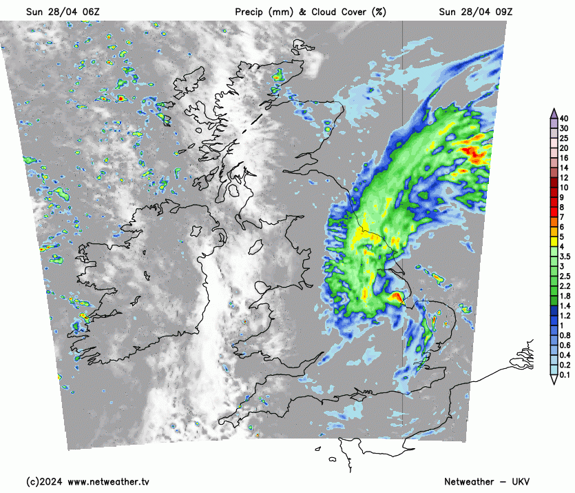
An area of persistent and fairly heavy rain that arrived across southern England yesterday evening has spread north overnight across the eastern half of England. 25-30mm has been recorded quite widely across parts of southern and SE England, a few spots around 40mm. Average April rainfall for these areas is around 45-50mm. Some spots here have seen over 150% of April’s average rainfall.
 Data from Starling Roost Weather
Rain will be slow to clear eastern areas this morning and will linger in the northeast through the afternoon, sunny spells and a few showers in the west. Weather fortunes reverse on Monday, with spells of rain moving in across the west and northern areas too, while much of eastern England escapes with a dry and bright day. Further rain likely in the west on Tuesday, drier and brighter in the east. Wednesday starting fine, but outbreaks of rain moving in across southern Britain, these pushing north across northern areas on Thursday, with drier, brighter and warmer conditions following across the south.
A great deal of uncertainty by the time we get to the first of two May Bank Holiday weekends next weekend. The current European ECMWF weather model run wants to build in high pressure bringing a dry, settled and warm weekend, while the American GFS model keeps low pressure close by, bringing unsettled conditions, before high pressure eventually builds in on Bank Holiday Monday, bringing a fine end to the long weekend.
Back to today, after a wet night, the rain across eastern England will persist through the morning, while also spreading northwest to affect the far east of Scotland through the day, rain accompanied by a brisk northerly wind. Rain tending to turn lighter across SE England while some heavy bursts continue north of the Wash this morning. Rain tending to clear out over the North Sea from eastern England during the afternoon, persisting across eastern Scotland, but perhaps remaining grey for much of the day across eastern England, with patchy drizzle.
In contrast, western areas will have a drier and brighter day, with sunny spells but also a scattering of showers – which will be hit-and-miss.
Temperatures struggling to 9-11C under the cloud and rain in the east, 12-13C in the brighter west.
Rain clearing north across eastern Scotland this evening before leaving northern Scotland in the early hours, otherwise a mostly dry night with clear spells for many, though showers look to affect western coastal counties. Turning quite chilly across Scotland and eastern England – with temperatures dropping into low single figures, which could bring a touch of ground frost in a few sheltered spots.
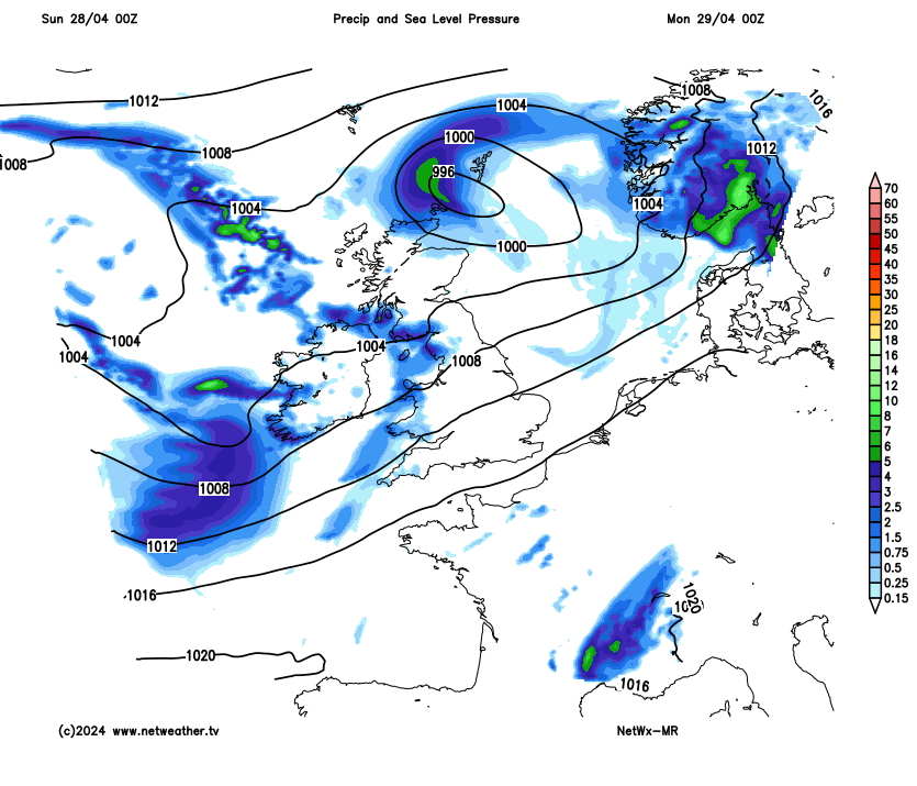
Pressure and rainfall Monday - Friday
Southeast and eastern England will stay mostly dry and bright on Monday, while cloud and outbreaks of showery rain will gradually spread in from the west across SW England, Wales, Midlands, northern England and Scotland through the day – before easing into the evening. Warmer than recently, with the flow from the south, temperatures reaching 12-16C, perhaps up to 18C in the southeast.
Low pressure will be close to the west and high pressure to the east on Tuesday, so it will be blustery, cool and showery in the west – drier, brighter and warmer in the east – where temperatures will reach 16-18C across eastern England. A risk of a few thundery showers clipping the far southeast and East Anglia in the evening.
Mostly dry and bright morning on Wednesday, before cloudier skies with outbreaks of rain spread north across England and Wales in the afternoon and evening. Scotland and N. England staying mostly dry and sunny, just the odd shower. Even warmer in the south, reaching 19C in London, 15C in Belfast and Cardiff.
Some uncertainty of over detail, but looks like outbreaks of rain spreading northwest over central and northern areas on Thursday and Friday, drier and sunnier for southern areas and the north of Scotland. Risk of thundery showers though towards the southeast Friday. Warm in the south.