
Further cyclonic developments in the coming days, but a potentially drier period developing towards mid-month. Technical update
Issued at 1600BST on Tue 6th June based on Tue 6th June 00Z Model Runs
Key Points

Discussion:
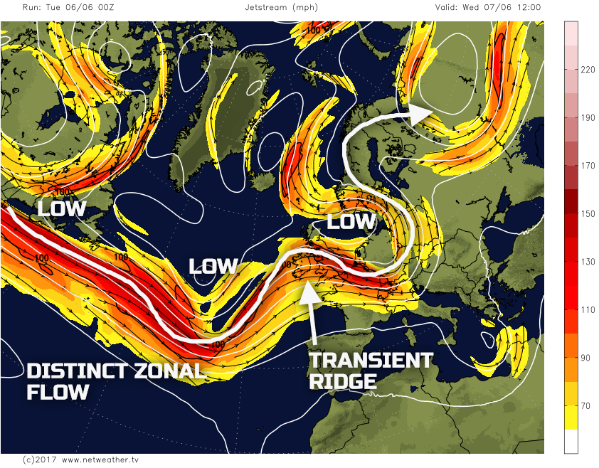
Wed 6th June: We move into Wednesday with a transient ridge moving across the UK, but with little amplification. The overall flow across the N Atlantic and into NW Europe is particularly zonal and progressive for the time of year. The jet stream reaching speeds of near 150KT or more across parts of the N Atlantic, with quite a southerly track as well. As a result, further cyclonic periods of weather will continue with individual low-pressure systems tracking towards the UK and then move up into or just to the W of the UK in the coming days.

The weather on Wednesday will, as a result of the transient ridge, be an improvement on the previous few days. The low pressure bringing wet and windy weather today (Tuesday) will still bring some rain and showers to the far north and north-east of Scotland, along with a blustery N or NW’ly wind. However, for much of the British Isles, a small ‘window’ of dry weather will develop through the day, along with some bright or sunny spells too. However, and importantly, the emphasis is on the word transient. The upper ridge will quickly move across the UK through the day with another cyclone approaching from the SW, and this will bring frontal cloud and rain across Ireland, Wales and SW England towards the end of the afternoon and into the evening, before spreading N and E into the overnight period.

Thu 7th June: Through into Thursday and confidence regarding the broader synoptic pattern has high confidence, with a good model agreement between the UKMO, GFS, GEM and ECMWF for low pressure to be situated just to the W of Ireland through the day. There is, however, some considerable uncertainty over precipitation details. The primary reason for this is that there could be a mixture of more dynamic, frontal rain, but also with convective precipitation too. Outbreaks of rain and showers are forecast to spread N and E during the day, with some further locally heavy rain possible across parts of Wales, Midlands and N England. Following on behind could be heavy and thundery showers across parts of the S and W of the UK to complicate matters. It would seem that the best of the conditions through the day will be across central and northern areas of Scotland. Here, frontal precipitation is unlikely to arrive until late in the day, with mainly dry conditions dominating, compared to elsewhere.
The forecast SBCAPE (Surface Based CAPE) from our MR weather model, highlights this convective threat through the day. If the frontal cloud does break and allows some surface heating, then the combination of this with low GPH will produce a particularly unstable atmosphere. At the moment the risk does seem to be across Ireland, Wales and SW England into Thursday afternoon, but with the risk of heavy and thundery downpours then spreading further N and E as the day progresses. However, the emphasis is that amongst this risk of convective precipitation will also be some more dynamic frontal rain too, most likely across parts of N England and into S Scotland during the afternoon.

The forecast sounding for Manchester towards midday on Thursday highlights this convective threat as well. Forecast soundings before this time though, through the morning show a profile that is representative of frontal precipitation. However, any solar influence through the afternoon, in association with even limited cloud breaks, could well lead to particularly unstable conditions. The forecast sounding showing cloud tops up to near 300mb or 29,000ft.

Fri 8th June: We end the working week with another transient and minor ridge of high pressure moving across the country through the day, as a shortwave upper trough clears to the E. However, this will, once again, be in advance of another significant cyclonic development upstream to the W and SW of the UK.

The weather across the UK through the day will be a mixture of sunshine and showers. The short-wave trough clearing away to the NE may well persist through the day to allow for a convective regime to develop. Indeed, the UKMO, ECMWF, GFS and GEM all have this trough close enough to allow for some instability across more central and northern areas through the day. As a result sunshine and showers are forecast for N England and Scotland, these locally heavy, but then easing as the afternoon and evening progress and the trough clears E. Later in the day, yet another area of low pressure will arrive from the SW which will bring frontal cloud and rain up from the SW.
Our medium range model highlights this evolution well. The position of the upper-level jet stream is indicated, but the convective regime across N areas, in particular, is well highlighted, as is the next approaching area of low pressure and associated frontal precipitation.

Sat 9th and Sun 10th June: So, we move into the weekend, and the overall weather pattern does have high confidence. All the 00Z models, including the associated ENS, have low pressure situated just to the W and NW of Ireland, this bringing a cyclonic S or SW’ly air flow across much of the UK. As is the case with the previous few days, given the time frame involved, there are some uncertainties over the precipitation details and position of frontal zones.

With the central area of low pressure in this location then Saturday is looking an unsettled day, especially across more N and W areas of the UK. Showers and longer spells of rain are forecast. This additional rainfall could increase the risk of localised flooding across areas which will, by this point, will have experienced a lot of rainfall through the previous week. It is likely to be unseasonably windy again too, with a fresh or strong S or SW’ly flow across Scotland, Ireland, N England and Wales. The best of the conditions through the day may well be across the extreme SE of England. Here it may well be drier and also warmer, given the SW’ly Tm air flow with a rather warm and humid day possible. This would be complete contrast though to further N and W, with more of an rPm air mass across Scotland and Ireland.
The GEM model, highlights this general evolution, as things stand well. Note various regions of vorticity are moving NE across the UK, around the main surface low pressure and this is creating the uncertainty over precipitation details, but it is likely that most of the rain and showers will be across the N and W.

Into Sunday and, at the moment, it should be something of an improving scenario across England and Wales, with drier, sunnier and warmer conditions developing. However, the low pressure is still likely to be passing to the NW of Scotland through the day, so it is across Scotland and Ireland that the risk of rain and showers may well persist into Sunday. It is, primarily, the behaviour of the low pressure by the time we get to Sunday that will determine how unsettled the weather will still be across parts of the N and W of the UK.
Temperatures will be on a steady rise through the rest of the week and into the weekend for most. The track of the low-pressure systems later in the week is from the SW, and this will bring with them a Tm air mass. After the unusually cool weather of present, given more of a W or NW’ly flow, temperatures will rise, potentially reaching 21C to 23C across parts of the S and E to end the week. However, it will be cooler further N and W given the predominantly unsettled weather.
Medium and Longer Term 11th June onwards:
Looking towards the mid-June period and beyond and there is evidence of some rise in pressure, perhaps not bringing a sustained period of summer-like weather, but at least an improvement than compared with of present. There are however some model differences. The 00Z ECM is less keen about this building ridge of higher pressure towards mid-month, and this does cast some doubt on the situation. The most recent EC Monthly forecast does, however, show a slight positive pressure anomaly over the UK as well.
Using the 00Z GFS ENS mean for the 16th as a general guide it is evident that GPH increases over the UK towards mid-month. However, this overall signal isn’t a particularly significant and neither is the current rise in GPH either. As a result, we could still be looking at a further changeable period of weather through the second half of the month. The more settled spell around mid-month will then be broken down by lower pressure returning from the W. This evolution though is uncertain, but as things stand a sustained period of summer weather across the whole UK does look unlikely in the coming weeks.


.jpg?w=350)

