A progressive and rather zonal period of weather is expected for early June. Not as hot and humid and more chance of rain, particularly in N & W
Issued at 1500BST on Tue 30th May based on Tue 30th May 00Z Model Runs
Key Points

Discussion:
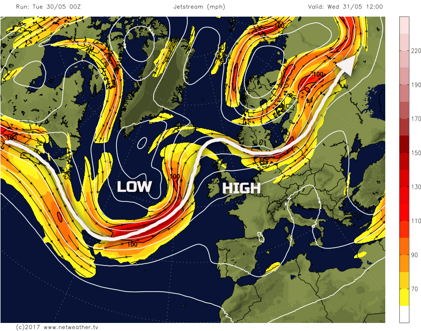
Wed 31st May: Into Wednesday and the pattern across the N Atlantic will be progressive and mobile. However, a marked trough within the N Atlantic, associated with a rather deep and unseasonable area of low pressure, will lead to marked WAA downstream towards the UK. This WAA, amongst other processes, does mean that GPH will be rising across the UK through the day. As a result after a more unsettled period of weather in the last few days, Wednesday, for much of the UK will see predominantly fine and settled conditions. This building ridge, downstream of the upper trough/vortex and low surface pressure, is highlighted well by the 00Z GFS model for 1200Z on Wednesday.
It will be a chilly start across many areas of the UK, noticeably in the countryside and after recent warmth. However, much of the day will be dry with bright or sunny spells, these prolonged at times. Forecast soundings show subsided profiles and, as a result, fair weather Cu or Sc type clouds are most likely during the day. A few isolated light showers may develop across parts of Wales and SW England, given just about enough convective depth, but this will be the exception to the rule. After the more unsettled and cloudy spell, Wednesday will be a very pleasant late spring day.

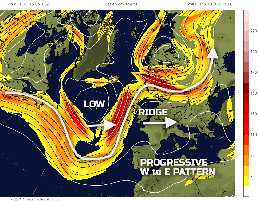
Thu 1st June: Through into Thursday and it will be a cool start, especially rurally. However, the overall pattern across the UK remains more anticyclonic than cyclonic, initially at least. However, the progressive weather pattern means that the high pressure begins to decline to the E of the UK through the day. This means that frontal systems will move into more N and W areas of the UK, but with much of England and Wales having pleasantly warm conditions with bright or sunny spells. The 00Z models are in all good agreement regarding this pattern and, using the 00Z GFS as an example; you can see how the ridge is being pushed away to the E, by the advancing upper vortex that was, in part, responsible for its development. This pattern is what will lead to a more unsettled regime developing across Scotland and Ireland, in particular, through the day.

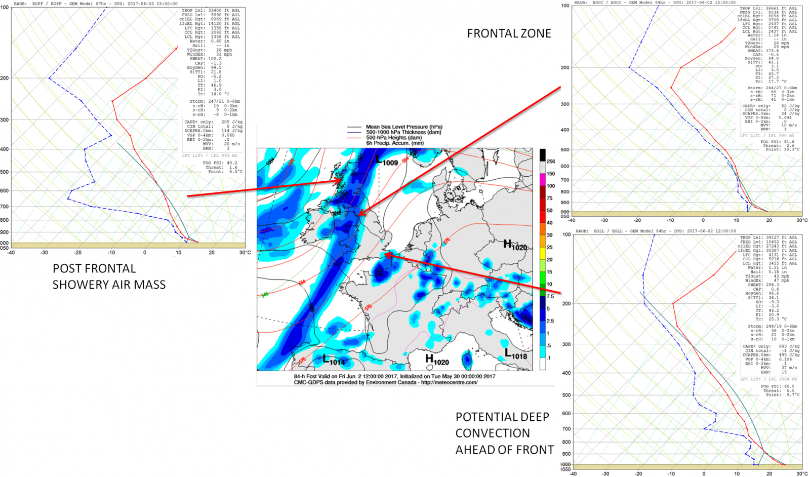
The forecast sounding for Birmingham show predominantly dry conditions prevailing and is representative of much of England and Wales. Quite a marked region of dry air remains in evidence between 800mb and 600mb in particular, but with some limited depth of instability allowing for fairly extensive Cu development. Equally, as the day progresses, the upper levels do become more moist indicative of an approaching frontal zone with, as a result, some high-level Ci or Cs clouds perhaps appearing. So, while a pleasantly warm day will develop with bright or sunny spells across England and Wales, it will be a bit cloudier than Wednesday overall.

The frontal system is, initially at least, well forced with some moderate or locally heavy outbreaks of dynamic, frontal rain moving into Scotland and Ireland during the day, which the 00Z GEM model highlights well. There have been some differences over whether a frontal wave develops along the front, a cold front, during the latter half of the day but this now looks unlikely. However, the front is relatively slow moving, and it is likely that Scotland and Ireland will maintain wet weather throughout much of Thursday.

Fri 2nd June: We end the working week with the frontal zone very slowly moving south-eastwards across England and Wales. There remains a 20% to 30% chance that the front may develop a frontal wave which, if it does, would increase the overall signal for precipitation and also lead to a much slower progression towards the SE. For now, though, three distinct weather regimes are forecast to be in evidence across the British Isles. The most straightforward being across Scotland and Ireland, so post front. Here a relatively cool and showery air mass will dominate through the day. Forecast profiles aren’t particularly unstable, but a scattering of light or moderate showers could well develop, despite some sunshine. The next region will be through some central areas, so across N England, down into Wales and the SW England. Here a mostly cloudy and overcast period of weather will dominate with outbreaks of rain, this slowly moving away from these regions through the afternoon and evening. Ahead of the frontal zone could well be an area of instability, across SE England, where a thermal plume may well be in evidence ahead of the front. These three regimes are highlighted well by the 00Z GEM model.
Sat 3rd and Sun 4th June: Into the forthcoming weekend and, overall, the broader synoptic pattern does have high confidence. All the primary 00Z GM’s (UKMO, ECMWF, GFS and UKMO) have an area of low pressure dominating just to the W and NW of the UK. The frontal system from Friday should have cleared away to the SE of the UK before Saturday morning, but given the potential development of a frontal wave, then heavy and perhaps thundery conditions may well still be in evidence. However, the synoptic pattern for Saturday is one of a cyclonic W or SW’ly type. As a result, the sunshine and scattered showers are forecast to develop across many areas of the British Isles, but these most frequent and heaviest across the N and W, nearest to the area of low pressure and associated upper vortex.

The other noticeable and noteworthy aspect of the broader synoptic pattern into the weekend is the development of quite a pronounced jet stream across the N Atlantic. A combination of some CAA from higher latitudes, with WAA from the tropics, will signal a well-organised jet for the time of year. This jet stream pattern may well then have implications on the weather for next week with a potentially unsettled or very unsettled period of weather developing as we move into early June.

The details of the shower distribution and intensities does remain somewhat problematic, but it is likely to be Scotland, Ireland, N England and Wales that see the heaviest and most frequent showers, whereas further S and E, then the showers will likely be well scattered with some decent drier and sunnier intervals too. The air mass over the UK as well will be an rPm and, as a result, a warm period of weather is unlikely. While wind directions will be W or SW’ly, at times, analysis of 850mb temperatures and other variables indicate a cool air mass. Our MR weather model shows 850mb temperatures to be <+4C across much of the British Isles as the weekend progresses. Given the time of year in any sunshine, it will feel pleasant enough, but nights will be cool, and especially when showers are most frequent then temperatures are likely to be slightly below average for early June.

Medium and Longer Term 5th June onwards:
The previously highlighted jet stream pattern is likely to be of primary importance next week. This is set to maintain a rather zonal and, overall, cyclonic pattern across the N Atlantic and into the UK. Indeed, all the 00Z GM’s indicate a secondary area of low pressure is moving out of Newfound and crossing the Atlantic, joining the slow moving vortex from the weekend into early next week.

Also by the time, we get to T+216hr, or next Thursday 8th June the 00Z ECMWF model has a very deep and vigorous area of low pressure moving into the UK from the SW. Apparently this does look to be an outlier solution, but equally, there are other EC ENS members who show such development. Given the organised jet stream pattern, if areas of low pressure do fall onto the ‘cold side’ of the jet stream within the region of divergence (left exit), then some particularly deep low-pressure systems could well develop as early June progresses.

So, to summarise the opening 7 to 14 days of June, the current prediction is one where the pattern is far more cyclonic than anticyclonic. Temperatures, overall, look set to be near to average at best, perhaps slightly above with SE England the first region to see any warmth if the SW’ly backs enough. However, high pressure certainly doesn’t look like being a feature of the weather, not for any considerable time and across northern and western regions of the British Isles then it could well be a potentially very wet start to the summer. All eyes will be on the development of the jet stream pattern into early June and whether this helps to spawn any deep low-pressure systems, as per 00Z ECMWF, which could bring some unseasonably wet and windy weather to parts of the UK.